| A PIECE BY ITSELF |
Surveyed 9/1/1771 by Basil Burgess; Patented in Sep 1797 by Wiilliam Hobbs for 52 acres repatented as Trouble For Nothing; Surveyed for Samuel Mansell in 1771 "on the south side of Patapsco Falls and about eighty yards from the said falls and on the west side of a draught or small branch that descends into the said falls" |
Mt. Airy |
http://guide.mdsa.net/pages/item.aspx?ID=S1189-149 |
| A SLIPE BY CHANCE |
Surveyed 9/27/1732 by Henry Ridgely; Patented in Jun 1734 by John Oliver for 100 acres repatented as Oliver's Chance; "on the south side of the Maine falls of Patapsco River Beginning at a bounded white oak it being also the beginning tree of Daniel Rawlings his part of a tract of land called Good Fellowship taken up by Mr. Christopher Randall of Baltimore County" |
Ellicott City - West |
http://guide.mdsa.net/pages/item.aspx?ID=S1189-154 |
| A STONY HILL SIDE |
Surveyed 3/24/1729 by Henry Ridgely; Patented in Jan 1731 by Charles Pierpoint for 15 acres; "Between a tract of land called Chews Vineyard Manner [Manor] and the great falls of Patapsco River" starting "between the said falls and a race dugg by the said Pierpoint for to build a water mill thereon" |
Ellicott City - East |
http://guide.mdsa.net/pages/item.aspx?ID=S1189-155 |
| ACCIDENT |
Surveyed 9/14/1775 by Basil Burgess; Patented in Sep 1775 by James Kirby for 3 acres; "Beginning at the end of ten perches in the north twenty six degrees east eighty perch course of the land called Hatherly's Resolution" |
Ellicott City - West |
http://guide.mdsa.net/pages/item.aspx?ID=S1189-6 |
| ACCORD |
Surveyed 5/27/1757 by Richard Shipley; Patented in May 1757 by James Hood for 42 acres; "on the south side of the western falls of Patapsco near the mouth of a branch called the Great Bridge Branch next adjoyning a tract of land called Johns Chance" starting at the end of the twelfth course of Johns Chance |
Sykesville |
http://guide.mdsa.net/pages/item.aspx?ID=S1189-7 |
| ACORN HILL |
Surveyed 11/16/1794 by Vachel Stevens; Patented in Dec 1794 by John Welsh for 49 acres; Adjoining Additional Defense but does not say where |
|
http://guide.mdsa.net/pages/item.aspx?ID=S1212-2 |
| ADAM THE FIRST |
Surveyed 10/1/1687; Patented in Oct 1687 by Adam Shipley for 500 acres repatented as Adam The First And Adam The Second Resurveyed; Resurveyed with vacancies for 580 acres in May 1742. |
Ellicott City - West |
|
| ADAM THE FIRST AND ADAM THE SECOND RESURVEYED |
Surveyed 5/21/1742 by William Cromwell; Patented in May 1742 by Adam Shipley for 137 acres; A portion of the resurveyed Adam The First with vacancies |
Ellicott City - West |
http://guide.mdsa.net/pages/item.aspx?ID=S1189-9 |
| ADAMS FORREST |
Surveyed 9/21/1741 by William Cromwell; Patented in Oct 1743 by Adam Barnes for 287 acres repatented as Invasion; "on the head drafts of Middle River" beginning at bounded trees of Henry's Park |
Sykesville |
http://guide.mdsa.net/pages/item.aspx?ID=S1189-8 |
| ADDITION - Carroll |
Patented in Mar 1703 by Charles Carroll for 3000 acres |
Ellicott City - West |
|
| ADDITION - Duvall |
Surveyed 5/8/1733 by Henry Ridgely; Patented in May 1733 by Lewis Duvall for 100 acres repatented as Lewises Lot; "on the west side of a tract of land called Broken Land" beginning "near to the end of the north two hundred perches course of a tract of land called Clarks Direction" |
Laurel |
http://guide.mdsa.net/pages/item.aspx?ID=S1189-1464 |
| ADDITION TO ACORN HILL |
Surveyed 11/16/1794 by Vachel Stevens; Patented in Dec 1794 by John Welsh for 25.75 acres; Beginning at the end of the 33rd course of Hobsons Choice, this parcel was not patented as it was wholly disconnected from Acorn Hill and that is not allowed in a single patent |
|
http://guide.mdsa.net/pages/item.aspx?ID=S1212-2 |
| ADDITION TO BROTHERS LEVEL |
Surveyed 3/1/1744 by William Cromwell; Patented in Nov 1745 by Robert Barnes for 420 acres; Resurvey of Brothers Level "on the head drafts of Howards Branch descending into Snowdens River". |
Glenelg |
http://guide.mdsa.net/pages/item.aspx?ID=S1189-28 |
| ADDITION TO CHAMPION FORREST |
Surveyed 10/14/1765 by Orlando Griffith; Patented in Oct 1765 by John Hammond for 96 acres; "on the drafts of a run called Deep Run adjoining to a tract of land called The Anvil beginning at the original beginning place of a tract of land called September the 14 1739" |
Jessup |
http://guide.mdsa.net/pages/item.aspx?ID=S1189-31 |
| ADDITION TO CHANCE |
Surveyed 3/21/1785 by Vachel Stevens; Patented in Mar 1785 by Charles Carroll for 8 acres; adjoining Doororegan, Chance, and The Discovery |
Ellicott City - West |
http://guide.mdsa.net/pages/item.aspx?ID=S1189-33 |
| ADDITION TO CHESTNUT HILL |
Surveyed 3/25/1771 by Basil Burgess; Patented in Mar 1771 by Philip Hammond for 30 acres; "adjoining a tract or parcel of land called Chestnut Hill now is the possession of the said Philip Hammond Beginning at the end of the thirty seventh course of the said land" |
Mt. Airy |
http://guide.mdsa.net/pages/item.aspx?ID=S1189-36 |
| ADDITION TO CONCORD |
Surveyed 4/21/1762 by Joshua Griffith; Patented in Apr 1762 by John Hood for 25 acres repatented as Break Neck Hill; "Beginning at the beginning trees of the land called Concord .. on the west side of the Great Bridge Branch" |
Cooksville |
http://guide.mdsa.net/pages/item.aspx?ID=S1189-38 |
| ADDITION TO DORSEYS SEARCH |
Surveyed 2/18/1802 by Baruch Fowler; Patented in Feb 1802 by Richard Ridgely for 15.75 acres; Adjoining Dorseys Search |
Ellicott City - West |
http://guide.mdsa.net/pages/item.aspx?ID=S1189-43 |
| ADDITION TO FREEBORNS PROGRESS |
Surveyed 2/18/1802 by Baruch Fowler; Patented in Feb 1802 by Richard Ridgely for 4 acres; Adjoining Freeborns Progress and Dorseys Search |
Ellicott City - West |
http://guide.mdsa.net/pages/item.aspx?ID=S1189-43 |
| ADDITION TO GARDNERS GARDEN |
Surveyed 2/26/1719 by John Dorsey; Patented in Sep 1724 by William Gardner for 200 acres repatented as Mount Hebron; in Baltimore County "on both sides the main falls of Patapsco River"; adjoining Hebron and Mount Calvary according to their patents |
Ellicott City - West |
http://guide.mdsa.net/pages/item.aspx?ID=S1190-197 |
| ADDITION TO GOOD FOR LITTLE |
Surveyed 5/26/1772 by Basil Burgess; Patented in Jan 1775 by William Selman for 20 acres; "Beginning at the end of twenty four perches on the fifteenth line of a tract or parcel of land called Good For Little"; appears to have been surveyed as Larkins Inheritance in 1810 - perhaps land became escheat? |
Elkridge |
http://guide.mdsa.net/pages/item.aspx?ID=S1189-49 |
| ADDITION TO GOOSE NECK |
Surveyed 1/22/1746 by Richard Shipley; Patented in Jan 1746 by Benjamin Lawrence for 25 acres repatented as Benjamin's Addition; "between a tract of land called Goose Neck and a tract of land called Pheasant Ridge" |
Glenelg |
http://guide.mdsa.net/pages/item.aspx?ID=S1189-51 |
| ADDITION TO HALF PONE |
Surveyed 5/7/1764 by Joshua Griffith; Patented in Jun 1765 by Charles Carroll for 9 acres; "on a draft of Patuxent River", adjoining Mary's Lott |
Ellicott City - West |
http://guide.mdsa.net/pages/item.aspx?ID=S1189-57 |
| ADDITION TO HARBERTS CARE |
Patented in Jun 1706 by Burridge Scott for 50 acres repatented as Hammond's Discovery; Three parcels of land formerly part of this survey were resurveyed for Hammond's Discovery. |
Elkridge |
|
| ADDITION TO HATHERLYS FORREST |
Surveyed 4/14/1744 by William Cromwell; Patented in Apr 1744 by John Hatherly for 100 acres repatented as Hatherly's Contrivance; "on the south side of the main falls of Patapsco and on the drafts of Patuxent River near the Main Waggon Road leading to Monocacy" |
Ellicott City - West |
http://guide.mdsa.net/pages/item.aspx?ID=S1189-60 |
| ADDITION TO HAZARD |
Surveyed 1/6/1772 by Basil Burgess; Patented in May 1772 by Mathias Hammond for 6.5 acres repatented as Larances Purchase; "Beginning at the beginning trees of a tract or parcel of land called Bens Luck" |
Ellicott City - West |
http://guide.mdsa.net/pages/item.aspx?ID=S1189-62 |
| ADDITION TO HOBBS PARK |
Surveyed 2/13/1724 by John Dorsey; Patented in Jul 1725 by John Hobbs for 100 acres; in Baltimore County starting "at the last bound tree of a parcel of land called Cross's Forest and standing at the head of a run called Stoney Run", adjoining Stringer's Neglect |
Columbia - South |
http://guide.mdsa.net/pages/item.aspx?ID=S1190-229 |
| ADDITION TO HOODS HALL |
Surveyed 6/10/1725 by John Dorsey; Patented in Jun 1727 by Benjamin Hood for 100 acres; "on the west side of Patuxent River" beginning at the beginning trees of Hoods Hall |
Ellicott City - West |
http://guide.mdsa.net/pages/item.aspx?ID=S1190-230 |
| ADDITION TO HOODS HALL AND BENS LUCK |
Surveyed 1/6/1772 by Basil Burgess; Patented in May 1772 by Mathias Hammond for 6 acres; lying between Hoods Hall and Ben's Luck |
Ellicott City - West |
http://guide.mdsa.net/pages/item.aspx?ID=S1189-64 |
| ADDITION TO HOPSONS CHOICE |
Surveyed 4/11/1721 by John Dorsey; Patented in May 1725 by John Mackinzie for 100 acres repatented as Mount Hebron; in Baltimore County "on the south side the main falls of Patapsco River", adjoining Margrett's Fancy |
Ellicott City - West |
http://guide.mdsa.net/pages/item.aspx?ID=S1190-227 |
| ADDITION TO JOSEPHS ADVANCEMENT |
Surveyed 2/24/1757 by Richard Shipley; Patented in Dec 1753 by Joseph Hobbs for 578 acres repatented as Poverty Discovered; Resurvey of tract of same name "being in the head drafts of the Middle River of Patuxent", adjoining the Conclusion |
West Friendship |
http://guide.mdsa.net/pages/item.aspx?ID=S1189-72 |
| ADDITION TO KENDALLS DELIGHT |
Surveyed 1/6/1772 by Basil Burgess; Patented in May 1772 by Mathias Hammond for 6 acres repatented as Larances Purchase; "Beginning at a white oak by the north west branch it being the second boundary of Kendel's Delight" |
Ellicott City - West |
http://guide.mdsa.net/pages/item.aspx?ID=S1189-73 |
| ADDITION TO LONG BOTTOM |
Surveyed 1/29/1749 by Richard Shipley; Patented in Jan 1749 by John Hood for 45 acres repatented as Rich Meadow; "on the drafts of the western Falls of Patapsco River between a tract of and called Shipley's Search and a tract of land called the Invasion and joyning a tract of land called Longbottom" |
Sykesville |
http://guide.mdsa.net/pages/item.aspx?ID=S1189-75 |
| ADDITION TO MANSELLS RANGE |
Surveyed 1/13/1747 by Richard Shipley; Patented in Jan 1747 by Samuel Mansell for 107 acres repatented as Mansells Defense; Resurvey of Mansells Range beginning "on a levell on the west side of the head of a draft of Snowdens River called Nimble Johns Cabbin Branch" |
Woodbine |
http://guide.mdsa.net/pages/item.aspx?ID=S1189-78 |
| ADDITION TO MOUNT UNITY |
Surveyed 12/8/1794 by Vachel Stevens; Patented in Jul 1796 by John Ellicott for 46.75 acres; Beginning "at the beginning of a tract or parcel of land called Littleworth"; shown on the plat for West Ilchester |
Ellicott City - East |
http://guide.mdsa.net/pages/item.aspx?ID=S1189-80 |
| ADDITION TO NEW YEARS GIFT |
Surveyed 12/8/1722 by John Dorsey; Patented in Mar 1730 by Caleb Dorsey for 210 acres repatented as Addition To New Year's Gift Resurveyed; in Baltimore County "between Elk Ridge and the easternmost main branch of Patuxent River" adjoining New Year's Gift, survey done Dec 1722 but patent was denied the first time |
Columbia - East |
http://guide.mdsa.net/pages/item.aspx?ID=S1190-271 |
| ADDITION TO NEW YEARS GIFT RESURVEYED |
Surveyed 11/30/1753 by Richard Shipley; Patented in Nov 1754 by Edward Dorsey for 272 acres repatented as New Years Gift Enlarged; adjoining Talbotts Resolution, Whittakers Chance, Bells Chance, Higgins Chance And Dorsey's Friendship |
Columbia - East |
http://guide.mdsa.net/pages/item.aspx?ID=S1189-81 |
| ADDITION TO PART OF FREDERICKS BURGH |
Surveyed 3/3/1766 by Orlando Griffith; Patented in Mar 1766 by Benjamin Warfield for 350 acres repatented as Second Addition To Fredericksburgh; Resurvey of his part of "Fredericks Borough", he had the northern end |
Woodbine |
http://guide.mdsa.net/pages/item.aspx?ID=S1189-85 |
| ADDITION TO PHELPS LUCK |
Surveyed 4/3/1724 by John Dorsey; Patented in Jul 1725 by John Hammond for 118 acres repatented as Hammond's Elk Ridge Connection; in Baltimore County at Elk Ridge near the Elkhorn branch |
Columbia - East |
http://guide.mdsa.net/pages/item.aspx?ID=S1190-289 |
| ADDITION TO PORTERS CARE |
Surveyed 1/6/1772 by Basil Burgess; Patented in May 1772 by Mathias Hammond for 8 acres; "Beginning at the beginning trees of a tract or parcel of land called Hoods Hall" |
Ellicott City - West |
http://guide.mdsa.net/pages/item.aspx?ID=S1189-87 |
| ADDITION TO SNAP SHORT |
Surveyed 4/22/1757 by Richard Shipley; Patented in Apr 1757 by Robert Israel for 12 acres; "in the great fork of Patuxent River joining a tract of land called Snap Short" |
Clarksville |
http://guide.mdsa.net/pages/item.aspx?ID=S1189-98 |
| ADDITION TO STONEY HILL |
Surveyed 4/29/1773 by Basil Burgess; Patented in May 1774 by Samuel Dorsey for 19.5 acres; Surrounds Stoney Hill patented by Robert Barnes |
Glenelg |
http://guide.mdsa.net/pages/item.aspx?ID=S1189-100 |
| ADDITION TO STORE HOUSE HILL |
Surveyed 1/24/1771 by Basil Burgess; Patented in May 1772 by John Hood for 6.5 acres; "Beginning at the end of the fourth course of a tract or parcel of land called Store House Hill" |
Sykesville |
http://guide.mdsa.net/pages/item.aspx?ID=S1189-102 |
| ADDITION TO THE GROVE |
Surveyed 7/31/1753 by Richard Shipley; Patented in Sep 1762 by Peter Shipley for 315 acres repatented as Four Brothers Portion; Resurvey of The Grove (Resurveyed) "in the great fork of Patuxent River" adjoining White Wine And Claret and Snowdens Third Addition To His Manor |
Clarksville |
http://guide.mdsa.net/pages/item.aspx?ID=S1189-107 |
| ADDITION TO TIMBER NECK |
Surveyed 1/21/1734 by Henry Ridgely; Patented in Oct 1736 by Charles Carroll for 400 acres repatented as Timber Neck Corrected; "on both sides of a run called the Deep Run of Patapsco Beginning at the end of the first course of a tract of land called Scotts Folly" |
Hanover |
http://guide.mdsa.net/pages/item.aspx?ID=S1189-110 |
| ADDITION TO TROY |
Surveyed 2/18/1718 by John Dorsey; Patented in Aug 1719 by Caleb Dorsey for 100 acres; "lying at Elk Ridge in Baltimore County" |
Elkridge |
http://guide.mdsa.net/pages/item.aspx?ID=S1190-341 |
| ADDITION TO TUCKERS DELIGHT |
Surveyed 11/4/1723 by John Dorsey; Patented in Aug 1725 by William Tucker for 150 acres; in Baltimore County on the south side of the main falls of Patapsco River |
Ellicott City - East |
http://guide.mdsa.net/pages/item.aspx?ID=S1190-342 |
| ADDITION TO WHATS LEFT |
Surveyed 3/2/1783 by Vachel Stevens; Patented in Sep 1784 by William Shipley for 29.5 acres; Lying between What's Left, Shipley's Search, Good Neighborhood, and Last Shift |
Sykesville |
http://guide.mdsa.net/pages/item.aspx?ID=S1189-115 |
| ADDITIONAL CHANCE |
Surveyed 11/10/1755 by Richard Shipley; Patented in Nov 1755 by Samuel Mansell for 200 acres repatented as Additional Chance Increased; Resurvey of Chance - Mansell "on the head drafts of Snowden's River on a branch of the said river called Nimble Johns Cabbin Branch", adjoining Chestnut Hill |
Mt. Airy |
http://msa.maryland.gov/megafile/msa/stagser/s1100/s1189/000000/000019/tif/dsl00019-3.jpg |
| ADDITIONAL CHANCE INCREASED |
Surveyed 3/29/1769 by Basil Burgess; Patented in Mar 1769 by Edward Warfield for 520 acres; Resurvey of Additional Chance starting "on the east side of Nimble Johns Cabbin Branch", adjoining Chestnut Hill |
Mt. Airy |
http://guide.mdsa.net/pages/item.aspx?ID=S1189-34 |
| ADDITIONAL DEFENSE |
Surveyed 10/30/1754 by Richard Shipley; Patented in Nov 1754 by Samuel Mansell for 2384 acres repatented as Range Declined; Resurvey of Mansells Defense "on the head drafts of Snowdens River and on the head drafts of the western falls of Patapsco River in the barrans", adjoining Addition to Mansells Range, Mobberley's Desire, Chestnut Hill, Wise Mans Folly; mentions the north side of Indian Johns Cabbin Branch, Poplar Spring, also a spring at the head of a draft of the Cattail River, the waggon road |
Woodbine |
http://guide.mdsa.net/pages/item.aspx?ID=S1189-20 |
| ADDITIONAL PROGRESS |
Surveyed 3/18/1756 by Richard Shipley; Patented in Mar 1756 by John Whipps for 412 acres repatented as Whipps Hills; Resurvey of Progress "on the western falls of Patapsco River partly in Ann Arundell county and partly in Baltimore county" starting "at the end of the first course of the Forrest Grove", adjoining Shipley's Search, Whips Lott, Adams Garden |
Sykesville |
http://guide.mdsa.net/pages/item.aspx?ID=S1189-23 |
| ALTOGETHER |
Surveyed 5/10/1719 by Thomas Larkin; Patented in Jun 1736 by Thomas Worthington for 1200 acres; "lying on the dividing line of Ann Arundel and Baltimore County on the west side of the Middle River of Patuxent" |
Clarksville |
http://guide.mdsa.net/pages/item.aspx?ID=S1189-129 |
| ANYTHING - Moberley |
Surveyed 5/4/1730 by Henry Ridgely; Patented in Jun 1734 by John Moberley for 100 acres; "on the head of a branch of Snowden's River of Patuxent" and near Thomas' Lott, shares the same beginning trees with Everything according to that patent, shown on the plat for Moorehouse's Generousity |
Dayton |
http://guide.mdsa.net/pages/item.aspx?ID=S1189-146 |
| ANYTHING - Ridgely |
Surveyed 2/10/1759 by Loch Weems; Patented in Feb 1759 by Charles Ridgely for 56 acres repatented as Clover Land; "Beginning in the north eighty four degrees west line eight hundred and sixty perches from the beginning of said line it being the first course of a tract of land called The Woodford" |
Sykesville |
http://guide.mdsa.net/pages/item.aspx?ID=S1189-148 |
| ANYTHING WILL SUIT |
Surveyed 6/22/1775 by Basil Burgess; Patented in Jun 1775 by Samuel Mansell for 15 acres; "Beginning at the end of nine perches on the north thirty eight degrees east fifty eight perches line(?) of a tract or parcel of land called Hampton Court it also being the thirty seventh course of the said tract" |
Mt. Airy |
http://guide.mdsa.net/pages/item.aspx?ID=S1212-61 |
| ARNOLDS FANCY |
Surveyed 4/16/1747 by Richard Shipley; Patented in Apr 1747 by John Arnold for 50 acres; "on the south side of the western falls of Patapsco River and on the drafts of Patuxent" |
Ellicott City - West |
http://guide.mdsa.net/pages/item.aspx?ID=S1189-151 |
| ASH WEDNESDAY |
Surveyed 4/11/1771 by Basil Burgess; Patented in May 1772 by John Hood for 6.5 acres; "Beginning at the westernmost tree of two bounded white oaks standing on the east side of Locust Thickett Branch they being boundarys of a tract of land called Conclusion and also of a tract of land called Cumberland" |
West Friendship |
http://guide.mdsa.net/pages/item.aspx?ID=S1189-153 |
| ATHOLL |
Surveyed 1/22/1730 by Henry Ridgely; Patented in Aug 1732 by James Macgill for 600 acres repatented as Atholl Enlarged; "in a fork of Patuxent River called Winkepin fork" adjoining "Hunting Ground which said tree and stone stands on the east side nigh the mouth of a fork of a run called Beavers Run" |
Columbia - West |
http://guide.mdsa.net/pages/item.aspx?ID=S1189-156 |
| ATHOLL ENLARGED |
Patented in Sep 1763 by James Macgill for 875 acres repatented as Joseph's Gift |
Columbia - South |
http://guide.mdsa.net/pages/item.aspx?ID=S1189-157 |
| BACHELLORS CHOICE |
Surveyed 11/10/1725 by John Dorsey; Patented in Mar 1728 by Philip Howard for 100 acres repatented as Mount Hebron; "on the south side the main falls of Patapsco River Beginning at three bounded oaks standing close by the said falls at the mouth of a run said trees being the bounded trees of the land called Mayden's [Maidens] Bower surveyed for Jane Grey" |
Ellicott City - West |
http://guide.mdsa.net/pages/item.aspx?ID=S1190-510 |
| BACHELORS CHOICE |
Patented in Mar 1728 by Samuel Peele for 100 acres; see also Batchelor's Choice |
|
|
| BACHELORS HALL ENLARGED |
Surveyed 9/28/1820 by John Duvall; Patented in Nov 1820 by Richard Hopkins for 302.12 acres; Resurvey of Batchelors Hall |
Elkridge |
http://guide.mdsa.net/pages/item.aspx?ID=S1212-68 |
| BACHELORS HOPE |
Surveyed 10/20/1719 by John Dorsey; Patented in Mar 1728 by John Viner for 25 acres repatented as Brown's Purchase; Lying in Baltimore County near Elk Ridge; south of Vine's Chance as shown in Brown's Purchase patent formerly in Baltimore County |
Jessup |
http://guide.mdsa.net/pages/item.aspx?ID=S1190-519 |
| BACHOLDERS CHOYCE |
Surveyed 3/1/1726 by Richard Gist; Patented in Nov 1735 by Phillip Sewell for 85 acres repatented as Mount Hebron; "on the west side of the main falls of Patapsco River" beginning near "the head of a branch descending into the west side of the afsd falls of Patapsco River" |
Ellicott City - West |
http://guide.mdsa.net/pages/item.aspx?ID=S1190-511 |
| BARE GROUND |
Surveyed 6/10/1732 by Henry Ridgely; Patented in Jun 1734 by John Moberley for 57 acres; lying "in a fork of Snowden River of Patuxent called Pinkstones and Bradshaws fork" beginning "in a hallow on the eastward of Pinkstones and Bradshaws Settlement" |
Woodbine |
http://guide.mdsa.net/pages/item.aspx?ID=S1189-172 |
| BARE HILLS |
Surveyed 2/1/1718 by Thomas Larkin; Patented in Jun 1734 by John Parr for 100 acres; starting "on the east side of the Middle River of Patuxent" |
Columbia - South |
http://guide.mdsa.net/pages/item.aspx?ID=S1189-173 |
| BARNES FRIENDSHIP |
Surveyed 1/1/1746 by Richard Shipley; Patented in Mar 1746 by Peter Barnes for 250 acres; Resurvey of 106 acre Shipley's Search "between the head drafts of the Middle River of Patuxent and the western falls", adjoining Barnes' Hunt and Shipley's Search |
Sykesville |
http://guide.mdsa.net/pages/item.aspx?ID=S1189-175 |
| BARNES HUNT |
Surveyed 10/26/1733 by Henry Ridgely; Patented in Jun 1734 by Joshua Barnes for 64 acres repatented as Conclusion; "on the eastward side of the head of the Middle River of Patuxent", to the east side of Joshua Barnes' dwelling |
Sykesville |
http://guide.mdsa.net/pages/item.aspx?ID=S1189-176 |
| BARNES LUCK |
Surveyed 1/29/1729 by Henry Ridgely; Patented in Oct 1730 by James Barnes for 80 acres; "on the east side of Brown's River of Patuxent", adjoining Mt Gilboa |
Ellicott City - West |
http://guide.mdsa.net/pages/item.aspx?ID=S1189-177 |
| BARNES PLEASANT MEADOW |
Surveyed 5/10/1765 by Joshua Griffith; Patented in May 1762 by John Hood for 17 acres; "Beginning at the end of the sixth course of a tract of land called the Conclution (Conclusion)" |
Sykesville |
http://guide.mdsa.net/pages/item.aspx?ID=S1189-178 |
| BARNES PURCHASE |
Surveyed 7/2/1756 by Richard Shipley; Patented in Jan 1758 by Robert Barnes for 296 acres; Resurvey of the 50 acre tract This or None "on the branch of Snowdens River" near "the south side of the head of a draft of a branch called Nelson's Branch", adjoining the Addition to Brothers Level, Pheasant Ridge, Henry And Peter, and Round About Hills |
Glenelg |
http://guide.mdsa.net/pages/item.aspx?ID=S1189-179 |
| BARRAN HILLS |
Surveyed 3/25/1748 by Richard Shipley; Patented in Mar 1748 by Charles Carroll for 285 acres; Resurvey of Hockley partly in Anne Arundel County and partly in Baltimore County on both sides of the head of Patapsco River |
Elkridge |
http://guide.mdsa.net/pages/item.aspx?ID=S1189-180 |
| BARRYS DUCK |
Surveyed 3/12/1766 by Orlando Griffith; Patented in Jul 1768 by William Spurrier for 50 acres; starting "at the head of a small draft that descend into a branch called the Great Branch" |
Jessup |
http://guide.mdsa.net/pages/item.aspx?ID=S1189-186 |
| BATCHELORS DELIGHT |
Patented in Jun 1700 by Daniel Wells for 298 acres; Adjoining Clark's Directions to the north according to that resurvey |
Fulton |
|
| BATCHELORS HALL |
Patented in Mar 1695 by John Medcalf for 180 acres repatented as Bachelors Hall Enlarged; Adjoining Dorsey's Angles and Timber Neck and Hammond's Discovery; MSA site has 1694 in HoCo Tract Index |
Elkridge |
|
| BEAR GARDEN FOREST - Resurveyed |
Surveyed 5/31/1762 by John Murdock; Patented in Jun 1762 by John Pierce Duvall for 194 acres repatented as Bear Garden Forest Enlarged; Beginning "near the mouth and on the north side of a branch called the Bear Garden branch" lying partly in Frederick County and partly in Anne Arundel County |
Woodbine |
http://guide.mdsa.net/pages/item.aspx?ID=S1197-3720 |
| BEAR GARDEN FOREST ENLARGED |
Surveyed 12/14/1770 by Basil Burgess; Patented in Dec 1770 by Samuel Musgrove for 286 acres; Resurvey of Bear Garden Forest - Resurveyed with added vacancies lying partly in Anne Arundel and Frederick Counties |
Woodbine |
http://guide.mdsa.net/pages/item.aspx?ID=S1212-72 |
| BEARHEAD |
Surveyed 2/14/1750 by Richard Shipley; Patented in Oct 1752 by William Cumming for 30 acres repatented as Warfields Connection; lying in the Barrans starting "on a flat between the drafts of Snowdens River" |
Woodbine |
http://guide.mdsa.net/pages/item.aspx?ID=S1189-192 |
| BEAUTIFUL CRAFT |
Surveyed 11/15/1751 by Richard Shipley; Patented in Nov 1751 by William Glann for 50 acres repatented as Chestnut Hill; "on the head drafts of Snowdens River", starting "on the west side of a draft of Snowdens River known by the name of the White Marsh fork" |
Mt. Airy |
http://guide.mdsa.net/pages/item.aspx?ID=S1189-194 |
| BELLS CHANCE |
Surveyed 1/10/1733 by Henry Ridgely; Patented in Jun 1734 by Peter Bell for 100 acres; "on a place called Elkridge adoining to a tract of land originally called Stephens forrest" |
Columbia - East |
http://guide.mdsa.net/pages/item.aspx?ID=S1189-199 |
| BELTS CHANCE |
Surveyed 3/1/1720 by John Dorsey; Patented in Jul 1723 by Benjamin Belt for 232 acres repatented as Woodford; Baltimore County "on the south side of the main falls of Patapsco River" |
Sykesville |
http://guide.mdsa.net/pages/item.aspx?ID=S1190-658 |
| BELTS HILLS |
Surveyed 3/22/1719 by John Dorsey; Patented in Jul 1723 by John Belt for 800 acres; Baltimore County "on the south side the main falls of the Patapsco River", Vachel Dorsey inherited 790 acres located at or near Hood's Mill from his father John and his mother Honor Elder from her father John Elder according to J. D. Warfield. |
Sykesville |
http://guide.mdsa.net/pages/item.aspx?ID=S1190-659 |
| BELTS POINT |
Surveyed 1/12/1719 by John Dorsey; Patented in Jul 1725 by John Belt for 112 acres; in Baltimore County "on the south side of Patapsco River" starting "at a point on the upper side of a run called Deep Run ? bounded oak being supposed to be the beginning tree of a tract of land called Cusicks Forrest" |
Elkridge |
http://guide.mdsa.net/pages/item.aspx?ID=S1213-180 |
| BENJAMINS ADDITION |
Surveyed 3/6/1752 by Richard Shipley; Patented in Aug 1753 by Benjamin Howard for 505 acres; Resurvey of Goose Neck, Addition To Goose Neck, and Dorsey's Grove |
Glenelg |
http://guide.mdsa.net/pages/item.aspx?ID=S1189-200 |
| BENS DELIGHT |
Surveyed 12/7/1763 by Joshua Griffith; Patented in Dec 1763 by Henry Griffith for 46 acres repatented as Three Brothers; "near the main branch of Patuxent River and on the west side", adjoining Hoods Hall |
Ellicott City - West |
http://guide.mdsa.net/pages/item.aspx?ID=S1189-202 |
| BENS LUCK |
Surveyed 2/21/1728 by Henry Ridgely; Patented in Aug 1736 by Benjamin Stevens for 50 acres repatented as Three Brothers; "on the east side of the Patuxent River", between Pinkstone's Delight and Hoods Hall |
Ellicott City - West |
http://guide.mdsa.net/pages/item.aspx?ID=S1189-203 |
| BENSONS PARK |
Patented in Mar 1696 by Daniel Benson for 250 acres |
Ellicott City - East |
|
| BENSONS REQUEST |
Surveyed 10/25/1751 by Richard Shipley; Patented in Aug 1752 by Richard Snowden for 260 acres; Resurvey of Parr's Addition "in the great fork of Patuxent River", adjoining Boyce's Beginning, Bear Hill, Addition surveyed For Thomas Worthington, Scantline Lott, Athol, and Williams Lott |
Columbia - South |
http://guide.mdsa.net/pages/item.aspx?ID=S1189-204 |
| BEYOND FAR ENOUGH |
Surveyed 12/12/1729 by Henry Ridgely; Patented in Jun 1734 by Robert Nelson for 100 acres; "in the great fork of Patuxent River" .. "in the fork of a branch now called Hankeses Branch". Surveyed by Henry Ridgely for Peter Hanks 12 Dec 1729 and whose heirs sold to Robert Nelson on 15 May 1734. |
Glenelg |
http://guide.mdsa.net/pages/item.aspx?ID=S1189-207 |
| BISHOPS OUTLET |
Surveyed 9/2/1742 by William Cromwell; Patented in Nov 1742 by Thomas Bishop for 84 acres repatented as Hammonds Discovery - Charles; "adjoining to a tract of land called Bishops Range" starting "close on the west side of Poplar Branch" |
West Friendship |
http://guide.mdsa.net/pages/item.aspx?ID=S1189-214 |
| BISHOPS RANGE |
Surveyed 4/30/1741 by William Cromwell; Patented in Nov 1741 by Thomas Bishop for 171 acres repatented as Hammonds Discovery - Charles; "on the east side of Middle River" starting on the "west side of a draft called poplar(?) draft which said draft leads into horse runn" |
West Friendship |
http://guide.mdsa.net/pages/item.aspx?ID=S1189-215 |
| BITE THE BITER |
Surveyed 6/4/1723 by James Weems; Patented in Aug 1725 by Benjamin Gaither for 700 acres; "on the east side of Snowdens River of Patuxent" |
Highland |
http://guide.mdsa.net/pages/item.aspx?ID=S1189-212 |
| BITE THE SKINNER |
Surveyed 4/28/1760 by Loch Weems; Patented in Dec 1760 by Henry Ridgely for 821 acres repatented as John's Hurry; Resurvey of Hobson's Choice (spelled Hopson's in patent) |
Woodbine |
http://guide.mdsa.net/pages/item.aspx?ID=S1189-213 |
| BITT BY CHANCE |
Patented in May 1730 for 46 acres repatented as Davis' Purchase; Probably patented by Richard Davis |
Laurel |
|
| BLACK MEADOW |
Surveyed 7/16/1767 by Orlando Griffith; Patented in Nov 1767 by Elizabeth Dorsey for 11 acres; "Beginning at the end of the thirty fourth course of a tract of land called Dorseys Range" |
Glenwood |
http://msa.maryland.gov/megafile/msa/stagser/s1100/s1189/000200/000216/tif/dsl00216-2.jpg |
| BOWDENS FOLLY |
Surveyed 2/10/1721 by John Dorsey; Patented in May 1727 by Thomas Cockey for 50 acres repatented as Mount Misery; in Baltimore County "on the south side of the main fallls of Patapsco River"; 59.5 acres when repatented |
Ellicott City - East |
http://guide.mdsa.net/pages/item.aspx?ID=S1190-838 |
| BOYCES BEGINNING |
Surveyed 8/10/1717; Patented in Aug 1717 by James Boyce for 50 acres repatented as Roberts Lot; Original courses given in resurvey which has now become escheat and is basically renamed Roberts Lot |
Columbia - South |
http://guide.mdsa.net/pages/item.aspx?ID=S1189-1371 |
| BREAK NECK HILL |
Surveyed 1/23/1771 by Basil Burgess; Patented in Mar 1773 by John Hood for 169 acres; Resurvey of Addition to Concord starting "on the south end of a Stoney Ridge on the east side of a branch called the Great Bridge Branch", sound like it lies on both sides of the branch |
Sykesville |
http://guide.mdsa.net/pages/item.aspx?ID=S1189-229 |
| BRENT WOOD FOREST |
Surveyed 9/27/1769 by Basil Burgess; Patented in Jun 1770 by Samuel Mansell for 25 acres; "on the south side of Patapsco Falls in the Barrons" starting "at the head of a small draft of the said falls called the Bee Draft Branch; shown on plat for Split Tract |
Mt. Airy |
http://guide.mdsa.net/pages/item.aspx?ID=S1189-230 |
| BROKEN LAND |
Surveyed 6/10/1719 by Thomas Larkin; Patented in Oct 1722 by Thomas Worthington for 660 acres repatented as Worthingtons Addition; "beginning at three bounded white oaks of Ridgely's Neck" |
Laurel |
http://guide.mdsa.net/pages/item.aspx?ID=S1189-242 |
| BROOKE FIELDS |
Surveyed 1/14/1764 by John Murdock; Patented in Jan 1765 by James Brooke for 1663 acres; Resurvey 118 acres of Silence (granted to Philemon Dorsey and Elizabeth Ridgely for 726 acres in Aug 1753) in Frederick County, references "south side of Swan Harbour Branch" |
Woodbine |
http://msa.maryland.gov/megafile/msa/stagser/s1100/s1197/000700/000705/tif/dsl00705-6.jpg |
| BROTHERS ADDITION |
Surveyed 1/4/1808 by John Hatherly; Patented in Oct 1810 by Archibald Dorsey for 19 acres; adjoining Caleb's Purchase and Grecian Siege |
Elkridge |
http://guide.mdsa.net/pages/item.aspx?ID=S1189-245 |
| BROTHERS AGREEMENT |
Surveyed 3/18/1761 by Joshua Griffith; Patented in Apr 1761 by George Shipley for 470 acres repatented as Shipley's Content; Resurvey of The Neglect (granted to John Martin) starting "on the head of a small draft descending into the western falls of Patapsco River", one border "near to the waggon road" |
Mt. Airy |
http://guide.mdsa.net/pages/item.aspx?ID=S1189-247 |
| BROTHERS LEVEL |
Surveyed 9/29/1729 by Henry Ridgely; Patented in Jun 1734 by Robert Barnes for 154 acres repatented as Addition to Brothers Level; "on the head drafts of a branch of Snowdens River of Patuxent called Howards Branch", northward of Brothers Partnership |
Glenelg |
http://guide.mdsa.net/pages/item.aspx?ID=S1189-248 |
| BROTHERS LOVE |
Surveyed 11/16/1727 by Henry Ridgely; Patented in Oct 1730 by John Howard for 177 acres; "on a branch of Snowdens River of Patuxent called now Howards Branch" beginning "on a hill side and on the north side of the aforesaid Howard Branch and near a fork thereof" |
Dayton |
http://guide.mdsa.net/pages/item.aspx?ID=S1189-249 |
| BROTHERS PARTNERSHIP - Dorsey |
Surveyed 10/7/1720 by John Dorsey; Patented in Jun 1734 by Joshua Dorsey for 632 acres; "on the west side of a tract of land called Good Range" starting "at the end of the fourth line of a tract of land called Altogether and at the end of the fourth lines of the aforesaid tract of land called Good Range" |
Dayton |
http://guide.mdsa.net/pages/item.aspx?ID=S1190-900 |
| BROTHERS PARTNERSHIP - Shipley |
Surveyed 12/11/1722 by John Dorsey; Patented in Oct 1738 by Peter Shipley for 200 acres repatented as Partnership Renewed; in Baltimore County "on Elk Ridge" starting "at the head of a draft of a branch descending into Deep Run" |
Ellicott City - East |
http://msa.maryland.gov/megafile/msa/stagser/s1100/s1190/000800/000899/tif/dsl00899-3.jpg |
| BROTHERS PARTNERSHIP - Warfield |
Surveyed 8/8/1750 by Richard Shipley; Patented in Sep 1752 by John Warfield for 486 acres; Resurvey of Venison Park "in the great fork of Patuxent River and on both sides of a branch called Hammonds Great Branch, adjoining Rich Neck and Warfield's Range |
Laurel |
http://guide.mdsa.net/pages/item.aspx?ID=S1189-251 |
| BROWNS ADDITION - Joshua |
Surveyed 4/23/1741 by William Cromwell; Patented in Nov 1741 by Joshua Brown for 40 acres; "Between Ranters Ridge and Good Fellowship on the South side of Patapsco Falls" beginning "nigh a corner of Good Fellowship" |
Woodstock |
http://guide.mdsa.net/pages/item.aspx?ID=S1189-253 |
| BROWNS ADDITION - Thomas |
Surveyed 6/10/1762 by Joshua Griffith; Patented in Jun 1762 by Thomas Brown for 54 acres; starting at the beginning tree of Brown's Purchase |
Columbia - South |
http://guide.mdsa.net/pages/item.aspx?ID=S1189-254 |
| BROWNS CHANCE |
Surveyed 4/30/1765 by Joshua Griffith; Patented in Jun 1765 by Thomas Brown for 48 acres; Beginning at "the eighth bounder of a tract of land called Brown's Purchase" |
Elkridge |
http://guide.mdsa.net/pages/item.aspx?ID=S1189-257 |
| BROWNS CHANCE AND CAPTAIN DORSEYS FRIENDSHIP |
Patented in Jul 1702 by Thomas Brown for 574 acres |
Clarksville |
|
| BROWNS ENLARGEMENT |
Surveyed 7/17/1749 by Richard Shipley; Patented in Jan 1750 by Robert Brown for 298 acres; Resurvey of Far Enough starting near Howards Branch, adjoining Rocky Ridge, Hay Stack Meadow, and Browns Branch |
Glenelg |
http://guide.mdsa.net/pages/item.aspx?ID=S1189-259 |
| BROWNS FORREST |
Surveyed 5/10/1695; Patented in Mar 1696 by Thomas Brown for 387 acres repatented as Brown's Forrest (Resurveyed); Hammonds Inheritance; Rezin Hammond's part of 316 acres was resurveyed by Hammonds Inheritance and its courses are listed there, not sure why his part and Valentine Brown's part together exceed the acreage listed for this patent |
Ellicott City - West |
|
| BROWNS FORREST - Resurveyed |
Surveyed 2/17/1759 by Loch Weems; Patented in Sep 1810 by Valentine Brown for 213 acres; Resurvey of 200 acres of Brown's Forrest with 13 additional vacant acres |
Ellicott City - West |
http://guide.mdsa.net/pages/item.aspx?ID=S1189-260 |
| BROWNS HOPYARD |
Surveyed 3/2/1719 by John Dorsey; Patented in May 1725 by Robert Brown for 250 acres repatented as Joseph's Gift; "on both sides of Brown's River", adjoining Griffith's Range, Cockshill |
Columbia - South |
http://guide.mdsa.net/pages/item.aspx?ID=S1190-912 |
| BROWNS PURCHASE |
Surveyed 4/5/1728 by Henry Ridgely; Patented in Oct 1730 by John Brown for 748 acres repatented as Brown's Purchase Resurveyed; Resurvey of Vines Chance, Ridgelys Lot, and Batchelors Hope "on both sides of a great branch called Ridgelys Great Branch", formerly part of Baltimore County |
Jessup |
http://guide.mdsa.net/pages/item.aspx?ID=S1189-262 |
| BROWNS PURCHASE RESURVEYED |
Surveyed 9/9/1794 by Vachel Stevens; Patented in Mar 1808 by John Spurrier for 795 acres; Resurvey of Brown's Purchase starting "on the east side of Ridgelys Great Branch" at the beginning tree of the original tract |
Jessup |
http://guide.mdsa.net/pages/item.aspx?ID=S1189-263 |
| BRYER BOTTOM |
Surveyed 3/26/1762 by Joshua Griffith; Patented in Mar 1762 by John Hood for 25 acres repatented as Guinns Purchase; adjoining Woodford |
Marriottsville |
http://guide.mdsa.net/pages/item.aspx?ID=S1189-265 |
| BUNKERS HILL |
Surveyed 3/22/1776 by Basil Burgess; Patented in Mar 1786 by Samuel Chance for 580 acres repatented as Bunkers Hill Fortified; Resurvey of Shipley's Content, which was a resurvey of Brothers Agreement and The Neglect, extending the property to the Patapsco River; starting at the end of the first line of Mill Land |
Mt. Airy |
http://guide.mdsa.net/pages/item.aspx?ID=S1189-266 |
| BUNKERS HILL FORTIFIED |
Surveyed 7/24/1797 by Baruch Fowler; Patented in Feb 1800 by Jeremy T Chase for 712.5 acres; Resurvey of Bunkers Hill |
Mt. Airy |
http://guide.mdsa.net/pages/item.aspx?ID=S1189-267 |
| BURGESS LOOK OUT |
Surveyed 5/30/1765 by Joshua Griffith; Patented in Sep 1766 by Joseph Burgess for 320 acres; Resurvey of his part of Upland beginning "at the end of the tenth line of the whole tract" |
Dayton |
http://guide.mdsa.net/pages/item.aspx?ID=S1189-269 |
| CALEBS PASTURE |
Surveyed 4/26/1744 by William Cromwell; Patented in Apr 1744 by Caleb Dorsey for 262 acres repatented as Rockburn; "on the south side of Patapsco Falls Beginning at a bounded white oak of Mores[sic] Morning Choice standing in the head of a branch leading into the said falls and on the north side of the main road from Elkridge to the landing" |
Elkridge |
http://guide.mdsa.net/pages/item.aspx?ID=S1189-277 |
| CALEBS PURCHASE |
Patented in Mar 1730 by Caleb Dorsey for 1255 acres; adjoining The Neglect according to that survey |
Elkridge |
|
| CALEBS VINEYARD |
Surveyed 6/27/1744 by William Cromwell; Patented in Jun 1744 by Caleb Dorsey for 200 acres; "on the south side of the mane falls of Patapsco River" |
Ellicott City - East |
http://guide.mdsa.net/pages/item.aspx?ID=S1189-278 |
| CAMPBLES CHANCE |
Surveyed 7/16/1726 by James Weems; Patented in Jun 1734 by John Campble for 218 acres; "on the head of Grimmitts Branches and on the east side of the Second Addition to Snowdens Addition" starting "at the end of the first line of William Griffiths land and near the easternmost side of the aforesaid Second Addition" |
Fulton |
http://guide.mdsa.net/pages/item.aspx?ID=S1189-283 |
| CARRICK |
Surveyed 1/26/1771 by Basil Burgess; Patented in Apr 1771 by John Gardiner for 115 acres repatented as Mount Hebron; Resurvey of Yates Inheritance of 1717 beginning on the "draft side of a run called the Island Run Branch" |
Ellicott City - West |
http://guide.mdsa.net/pages/item.aspx?ID=S1212-104 |
| CARTERS ADDITION |
Surveyed 5/10/1732 by Henry Ridgely; Patented in Jul 1733 by Daniel Carter for 23 acres repatented as Mount Hebron; "on the South Side of the Main falls or great branch of Patapsco River", adjoining Maiden's Bower patented for Jane Grey |
Ellicott City - West |
http://guide.mdsa.net/pages/item.aspx?ID=S1189-289 |
| CARTERS ROCK |
Surveyed 4/8/1730 by Henry Ridgely; Patented in Jul 1733 by Daniel Carter for 100 acres repatented as Todd's Improvement; "on the South Side of the great falls of Patapsco River and near to the land formerly taken up by George Yate" |
Ellicott City - East |
http://guide.mdsa.net/pages/item.aspx?ID=S1189-290 |
| CARTERS WHIM |
Surveyed 5/26/1727 by Philip Jones; Patented in Jul 1737 by Daniel Carter for 88 acres repatented as Mount Hebron; in Baltimore County, adjoining Gray's Bower |
Ellicott City - West |
http://guide.mdsa.net/pages/item.aspx?ID=S1190-1058 |
| CATCH AS CATCH CAN |
Surveyed 3/5/1762 by Joshua Griffith; Patented in Mar 1762 by Joseph Hobbs for 60 acres repatented as What's Left - Hobbs; starting "on a point and near to the main draft of the Middle River of Patuxent" |
West Friendship |
http://guide.mdsa.net/pages/item.aspx?ID=S1189-294 |
| CHAMPION FORREST |
Surveyed 5/17/1727 by Philip Jones; Patented in Apr 1730 by Philip Hammond for 663 acres; Resurvey of Dorsey's Grove in Baltimore County "between the drafts of Patuxent and Patapsco River" beginning at "a ridge on the west side of the present Elk Ridge road about 20 yards thor[sic] from and about two hundred yards within the division line of Baltimore and Anarundell Cty" |
Jessup |
http://guide.mdsa.net/pages/item.aspx?ID=S1190-1086 |
| CHANCE - Carroll |
Patented in Sep 1709 by Charles Carroll for 969 acres repatented as Chance (Resurveyed) |
Ellicott City - West |
|
| CHANCE - Carroll Resurveyed |
Surveyed 6/4/1743 by William Cromwell; Patented in Dec 1743 by Charles Carroll for 1425 acres; Resurvey of Chance adjoining Doohoregan, Kendall's Delight, Kendalls Enlargement, and The Discovery |
Ellicott City - West |
http://guide.mdsa.net/pages/item.aspx?ID=S1189-303 |
| CHANCE - Mansell |
Surveyed 4/3/1746 by William Cromwell; Patented in Apr 1746 by Samuel Mansell for 42.5 acres repatented as Additional Chance; "on the head drafts of Snowdens River" beginning "on the west side of a branch called Nimble Johns Cabbin Branch" |
Mt. Airy |
http://guide.mdsa.net/pages/item.aspx?ID=S1189-306 |
| CHANCE - Pierpoint |
Surveyed 3/15/1757 by Richard Shipley; Patented in Mar 1757 by Henry Pierpoint for 35 acres; "joyning the following two tracts of land viz. Talbotts Resolution Manor and Long Reach Beginning at the end of the north west 436? Course of the afsd Talbotts Resolution Manor" |
Columbia - West |
http://guide.mdsa.net/pages/item.aspx?ID=S1189-305 |
| CHARITIES PURCHASE AND JAMES LOT |
Surveyed 5/2/1741 by William Cromwell; Patented in Nov 1741 by James Norwood for 200 acres; "near the head of Patuxent River" starting "close by a large spring called Sling mud{?) Spring which said spring falls into Poplar Spring Branch" |
Marriottsville |
http://guide.mdsa.net/pages/item.aspx?ID=S1189-313 |
| CHERRY BOTTOM |
Surveyed 2/16/1762 by Joshua Griffith; Patented in Feb 1762 by Samuel Musgrove for 18 acres; beginning "on the east side of the Cattail River" |
Woodbine |
http://guide.mdsa.net/pages/item.aspx?ID=S1189-317 |
| CHESTNUT HILL |
Surveyed 9/29/1753 by Richard Shipley; Patented in May 1754 by Nathan Hammond for 1246 acres; Resurvey of Beautiful Craft "on the head drafts of Snowdens River" adjoining Neal's Chance, on the SE side of Indian Johns Cabbin Branch |
Mt. Airy |
http://guide.mdsa.net/pages/item.aspx?ID=S1189-321 |
| CHESTNUT RIDGE |
Surveyed 3/7/1757 by Richard Shipley; Patented in Mar 1757 by William Hanks for 40 acres; "in the fork of Patuxent River Beginning at the end of the twenty fourth course of a tract of land called Worthington's Range" |
Clarksville |
http://guide.mdsa.net/pages/item.aspx?ID=S1189-322 |
| CHEWS RESOLUTION MANOR |
Patented in Nov 1695 by Samuel Chew for 1073 acres repatented as Chews Resolution Manor - Resurveyed; contains Avaco |
Ellicott City - East |
|
| CHEWS RESOLUTION MANOR - Resurveyed |
Surveyed 12/10/1718 by John Dorsey; Patented in Mar 1730 by Caleb Dorsey for 1318 acres; "lying at Elk Ridge in Baltimore County", adjoining Talbott's Resolution Manor |
Ellicott City - East |
http://guide.mdsa.net/pages/item.aspx?ID=S1190-1151 |
| CHEWS VINEYARD |
Patented in Nov 1695 by Samuel Chew for 1024 acres |
Ellicott City - East |
|
| CLARKS DIRECTIONS |
Patented in Feb 1730 by William Nicholson for 700 acres repatented as Clark's Directions - Resurveyed; Originally surveyed Oct 1718 according to resurvey |
Fulton |
|
| CLARKS DIRECTIONS - Resurveyed |
Surveyed 4/18/1738 by William Cromwell; Patented in Nov 1738 by Philip Hammond for 322 acres; Resurvey of tract of same name "on the South Side of another tract of land called Batchelors Delight and on the north side of a branch of Patuxent called Snowdons River", also adjoining Neal's Delight |
Fulton |
http://guide.mdsa.net/pages/item.aspx?ID=S1189-331 |
| CLARKS WALKS |
Patented in Jul 1702 by Richard Clark for 200 acres repatented as Clark's Walks - Resurveyed |
Laurel |
|
| CLARKS WALKS - Resurveyed |
Surveyed 11/1/1726 by James Weems; Patented in Jul 1741 by Nathan Hammond for 365 acres; Resurvey of a tract of the same name "in the fork of Patuxent River between a branch and said river" |
Laurel |
http://msa.maryland.gov/megafile/msa/stagser/s1100/s1189/000300/000333/tif/dsl00333-2.jpg |
| CLARYS FORREST |
Surveyed 1/9/1729 by Henry Ridgely; Patented in Jun 1734 by John Jr. Clary for 100 acres; "on the north side of a branch called Dorseys Great Branch" adjoining White Wine and Claret and another tract called Henry And Thomas |
Clarksville |
http://guide.mdsa.net/pages/item.aspx?ID=S1189-335 |
| CLOVER LAND |
Surveyed 11/29/1803 by Baruch Fowler; Patented in Nov 1806 by Hoop Chamberlain for 175 acres; Resurvey of Anything and part of Invasion |
Sykesville |
http://guide.mdsa.net/pages/item.aspx?ID=S1189-337 |
| COCKEYS NEGLECT |
Surveyed 5/13/1771 by Basil Burgess; Patented in Nov 1775 by Edward Dorsey for 24 acres; "Beginning at the side of the falls of Patapsco River it being at the end of the fourteenth course of a tract or parcel of land called Cockeys Regulation" |
Ellicott City - East |
http://guide.mdsa.net/pages/item.aspx?ID=S1189-339 |
| COCKEYS REGULATION |
Surveyed 1/30/1747 by Richard Shipley; Patented in Jan 1747 by Thomas Cockey for 212 acres repatented as Mount Hebron; Resurvey of The Long Discovery "on the south side of the Falls of Patapsco River about 12 miles above the head of said river", adjoining Yeate's Contrivance |
Ellicott City - East |
http://guide.mdsa.net/pages/item.aspx?ID=S1189-340 |
| COCKSHILL |
Patented in Nov 1710 by John Jones for 200 acres |
Columbia - East |
|
| COLES CHOICE |
Surveyed 11/20/1761 by Joshua Griffith; Patented in Jan 1762 by William Cole for 327 acres; Resurvey of Griffith's Range adjoining Jones' Fancy, Halls Lot, and Cocks Hill (Cockshill)) |
Columbia - South |
http://msa.maryland.gov/megafile/msa/stagser/s1100/s1189/000300/000342/tif/dsl00342-2.jpg |
| COLES CHOICE RESURVEYED |
Surveyed 6/29/1809 by John Hatherly; Patented in Jun 1810 by Alfred Cole for 454 acres; Resurvey of Cole's Choice, plat shows all adjoining lands and river |
Columbia - South |
http://guide.mdsa.net/pages/item.aspx?ID=S1189-343 |
| COLUMBIA |
Surveyed 6/1/1795 by Vachel Stevens; Patented in Jul 1804 by Samuel Goodman for 813 acres repatented as Columbia - Corrected; Resurvey of Find It If You Can adjoining The Warfields, Ridgely's Range, Stop The Gap, Warfield's Forrest, Good Will, Little-worth, Worthless, and Pleasant Meadows |
Woodbine |
http://msa.maryland.gov/megafile/msa/stagser/s1100/s1189/000300/000346/tif/dsl00346-7.jpg |
| COLUMBIA - Corrected |
Surveyed 7/14/1803 by Baruch Fowler; Patented in Jul 1804 by William Alexander for 813 acres; Corrected survey of Columbia |
Woodbine |
http://msa.maryland.gov/megafile/msa/stagser/s1100/s1189/000300/000346/tif/dsl00346-19.jpg |
| COLUMBIA - Resurveyed |
Surveyed 6/1/1795 by Vachel Stevens; by Samuel Goodman for 2420 acres; Resurvey of The Victory |
Woodbine |
http://msa.maryland.gov/megafile/msa/stagser/s1100/s1189/000300/000346/tif/dsl00346-7.jpg |
| CONCLUSION |
Surveyed 9/29/1750 by Richard Shipley; Patented in Oct 1752 by John Hood for 792 acres; Resurvey of Barnes Hunt "on the south side of the Western Falls of Patapsco River and on the head drafts of the Middle River of Patuxent" adjoining Barnes Friendship, Henry's Park, The Invasion; near a draft of Locust Thicket branch; plat shows the Barrans and Stoney Barran Ridge |
Cooksville |
http://guide.mdsa.net/pages/item.aspx?ID=S1189-349 |
| CONCORD |
Surveyed 8/10/1751 by Richard Shipley; Patented in Nov 1752 by John Hood for 108 acres repatented as Concord Resurveyed; "on the drafts of the Western Falls of Patapsco River" starting "on the west side of the Great Bridge Branch" |
Cooksville |
http://guide.mdsa.net/pages/item.aspx?ID=S1189-351 |
| CONCORD - Resurveyed |
Surveyed 7/17/1771 by Basil Burgess; Patented in Mar 1773 by John Hood for 513 acres; Resurvey of Concord Resurveyed adding vacancies on Baltimore County side |
Cooksville |
http://guide.mdsa.net/pages/item.aspx?ID=S1189-352 |
| CONCORD RESURVEYED |
Surveyed 11/16/1764 by Joshua Griffith; Patented in Mar 1765 by John Hood for 340 acres repatented as Concord - Resurveyed; Resurvey of Concord "at the end of the seventeenth course of a tract of land called Johns Chance" |
Cooksville |
http://guide.mdsa.net/pages/item.aspx?ID=S1189-353 |
| CONTENT |
Surveyed 1/20/1755 by Richard Shipley; Patented in Jan 1755 by Jason Frissell for 5 acres repatented as Contentment; This land was found to lie in Yates Contrivance so was resurveyed a few months later |
Ellicott City - East |
http://guide.mdsa.net/pages/item.aspx?ID=S1189-358 |
| CONTENTION |
Surveyed 12/1/1773 by James Calder; Patented in Jun 1773 by Joseph Hayward for 20 acres; "lying partly in Baltimore County and partly in Annarundel County beginning .. on the north east side of a hill on the west side of the main falls of Patapsco River a little above Ellicotts Mill"; never patented |
Ellicott City - East |
http://guide.mdsa.net/pages/item.aspx?ID=S1213-370 |
| CONTENTION ENDED |
Patented in Dec 1763 by Henry Ridgely for 370 acres |
Glenwood |
http://guide.mdsa.net/pages/item.aspx?ID=S1189-363 |
| CONTENTMENT |
Surveyed 5/12/1755 by Richard Shipley; Patented in Jan 1755 by Jason Frissell for 350 acres; Resurvey of Content "on west side of the main falls of Patapsco River" and bounding on it, adjoining Carter's Rock and Yeates Contrivance; Content was found to lie in Yates Contrivance so the resurvey was done shortly thereafter |
Ellicott City - East |
http://guide.mdsa.net/pages/item.aspx?ID=S1189-358 |
| COOPERS LOT |
Surveyed 4/3/1728 by Henry Ridgely; Patented in Jun 1734 by John Mewshaw for 100 acres; "on a branch in the fork of Patuxent River called Hammond's Branch", surveyed for John Mewshaw who turned over his rights to the property to John Worthington |
Laurel |
http://guide.mdsa.net/pages/item.aspx?ID=S1189-367 |
| COPPER HILL |
Surveyed 9/27/1731 by Henry Ridgely; Patented in Aug 1739 by John Gardner for 5 acres; "on the west side of the maine falls of Patapsco River and near to a tract of land called Carters Rock laid out for Daniell Carter", location described in Oella survey |
Ellicott City - East |
http://guide.mdsa.net/pages/item.aspx?ID=S1189-369 |
| COST UPON COST |
Patented in Jul 1749 by Robert Ridgely for 33 acres repatented as Felicity |
Columbia - West |
|
| COSTLY |
Surveyed 4/14/1767 by Orlando Griffith; Patented in Oct 1769 by Henry Howard for 29 acres; "Beginning at the end of the nineteenth course of a tract of land called Howards Resolution" |
West Friendship |
http://guide.mdsa.net/pages/item.aspx?ID=S1189-371 |
| COWICK HALL |
Surveyed 6/12/1725 by John Dorsey; Patented in Mar 1729 by Thomas Wainwright for 236 acres repatented as Upton Park; lying Baltimore County starting at "the first bounded trees of the land called Sewell's(?) Delight standing on the west side the main falls of Patapsco River" |
Ellicott City - East |
http://guide.mdsa.net/pages/item.aspx?ID=S1190-1338 |
| CREAGHS ENLARGEMENT |
Surveyed 2/24/1748 by Richard Shipley; Patented in Jul 1750 by James Creagh for 274 acres; Resurvey of Howards Chance and part of Mount Gilboa beginning at two oaks "standing on the east side of the main waggon road near the end of the south by west line of a tract of land called Hopsons Choice they being the original beginning trees of a tract of land called Hatherleys Resolution" |
Ellicott City - West |
http://guide.mdsa.net/pages/item.aspx?ID=S1189-379 |
| CROSSES FORREST |
Patented in 1697 by John Cross for 357 acres |
Columbia - East |
|
| CROW NEST BOTTOM |
Surveyed 10/19/1762 by Joshua Griffith; Patented in Oct 1762 by Mordecai Selby for 10 acres; "Beginning at the end of the seventh line of a tract of land called Shipley's Discovery", included on the Lost By Neglect plat shown in the northwest corner of the plat |
Cooksville |
http://guide.mdsa.net/pages/item.aspx?ID=S1189-387 |
| CUMBERLAND |
Surveyed 5/8/1751 by Richard Shipley; Patented in Oct 1752 by Adam Barnes for 640 acres; Resurvey of John's Lott "on the drafts of the Middle River of Patuxent", adjoining Invasion, Pheasant Ridge, Henry And Peter |
West Friendship |
http://guide.mdsa.net/pages/item.aspx?ID=S1189-388 |
| CURRY GALLS |
Surveyed 9/10/1744 by William Cromwell; Patented in May 1747 by Michael Wallis for 25 acres repatented as Curry Galls - Resurveyed; "near the head of the Middle Branch of Patuxent River".."on the north side of a branch called Mewshaw's Branch" |
Woodbine |
http://guide.mdsa.net/pages/item.aspx?ID=S1189-393 |
| CURRY GALLS - Resurveyed |
Surveyed 5/9/1751 by Richard Shipley; Patented in Aug 1753 by Michael Wallis for 289 acres repatented as Justice Required; Resurvey of Curry Galls referenced by survey of Justice Required but not found on MSA site |
Woodbine |
http://guide.mdsa.net/pages/item.aspx?ID=S1189-291 |
| DARBYS DESIRE |
Surveyed 10/20/1736 by William Cromwell; Patented in Aug 1739 by Josias Darby for 50 acres; "in the fork of Patuxent River next adjoyning to a tract of land called Hammond and Gest [Geist] Beginning at a bounded white oak standing in the north thirteen degree east line of the land" and running northeast from there |
Clarksville |
http://guide.mdsa.net/pages/item.aspx?ID=S1189-398 |
| DAVIS HILL |
Surveyed 3/3/1732 by Henry Ridgely; Patented in Nov 1737 by Thomas Davis for 50 acres; "in the Great Fork of Patuxent River" |
Laurel |
http://guide.mdsa.net/pages/item.aspx?ID=S1189-402 |
| DAVIS PASTURE |
Patented in Jun 1700 by Isaac Davis for 200 acres |
Fulton |
|
| DAVIS PURCHASE |
Surveyed 3/6/1739 by William Cromwell; Patented in Sep 1739 by Richard Davis for 244 acres; Resurvey of Bitt By Chance, Neal's Delight, and The Hoppyard "between the plantations of Thomas Mobberley and Philbert Wright" |
Laurel |
http://guide.mdsa.net/pages/item.aspx?ID=S1189-403 |
| DAYS DISCOVERY |
Surveyed 5/10/1734 by Henry Ridgely; Patented in Jul 1737 by James Barnes for 235 acres repatented as Three Brothers; originally surveyed by Col. John Dorsey for Nicholas Day but transferred to James Barnes; adjoining Mount Gilboa |
Ellicott City - West |
http://guide.mdsa.net/pages/item.aspx?ID=S1189-404 |
| DEAR BOUGHT |
Surveyed 4/11/1771 by Basil Burgess; Patented in May 1772 by John Hood for 3.5 acres; "Beginning at the end of nineteen perches on the south five degrees west thirty four perches line of a tract or parcel of land called Conclusion it being the second line from a bounded white oak the same being a boundary of the said tract" |
Cooksville |
http://guide.mdsa.net/pages/item.aspx?ID=S1189-409 |
| DEAVERS CHOICE |
Surveyed 1/20/1716 by John Clark; Patented in Sep 1723 by Stephen Deaver for 100 acres repatented as Rock Hall; in Baltimore County starting "on the west side of Brown's River" |
Columbia - South |
http://guide.mdsa.net/pages/item.aspx?ID=S1190-1474 |
| DEAVERS LOT |
Surveyed 5/9/1720 by John Dorsey; Patented in Jun 1727 by Stephen Deaver for 200 acres repatented as Rock Hall; in Baltimore County on both sides of Brown's River starting near the Great Stone at the mouth of the Island Meadow |
Columbia - South |
http://guide.mdsa.net/pages/item.aspx?ID=S1190-1478 |
| DEFIANCE - Dorsey |
Surveyed 9/2/1761 by Joshua Griffith; Patented in Sep 1761 by Philemon Dorsey for 100 acres; "beginning at the end of forty perches on the thirty eighth course of a tract of land called Silence" |
Woodbine |
http://guide.mdsa.net/pages/item.aspx?ID=S1189-416 |
| DEFIANCE - Hobbs |
Surveyed 9/1/1762 by Joshua Griffith; Patented in Sep 1762 by Joseph Hobbs for 80 acres repatented as The Trusty Friend; "between two drafts of the Middle River of Patuxent" |
Cooksville |
http://guide.mdsa.net/pages/item.aspx?ID=S1189-415 |
| DELAWARE BOTTOM |
Surveyed 9/28/1717 by John Clark; Patented in Aug 1719 by Elizabeth Jones for 300 acres repatented as Woodford; "lying in Baltimore County between the drafts of Patuxent River and Patapsco River". Sold to Samuel Howard by Matthias Hammond according to Hammond's Enlargement. |
Marriottsville |
http://guide.mdsa.net/pages/item.aspx?ID=S1190-1436 |
| DENTONS PART OF THE SECOND DISCOVERY |
Surveyed 3/3/1725 by Henry Ridgely; Patented in Sep 1729 by Vachel Denton for 500 acres; Resurvey of southern half of The Second Discovery for Vachel Denton |
Ellicott City - West |
http://guide.mdsa.net/pages/item.aspx?ID=S1190-4508 |
| DEPENDENCE |
Surveyed 4/22/1755 by Richard Shipley; Patented in Apr 1755 by John Dorsey for 928 acres repatented as Dependence Renewed; Resurvey of Struggle For Life "on the drafts of Snowdens River in the Barrans", adjoins Henry And Peter, Curry Galls, and Dorseys Range |
Glenwood |
http://guide.mdsa.net/pages/item.aspx?ID=S1189-417 |
| DEPENDENCE RENEWED |
Surveyed 3/25/1818 by John Duvall; Patented in Jan 1819 by Richard Dorsey for 478 acres; Resurvey of Dependence |
Glenwood |
http://guide.mdsa.net/pages/item.aspx?ID=S1189-418 |
| DISAPPOINTMENT |
Surveyed 9/2/1761 by Joshua Griffith; Patented in Sep 1761 by Philemon Dorsey for 400 acres repatented as Resurvey On The Disappointment; "beginning at the end of the forty-fifth course of a tract of land called Silence" and proceeding north and west from there |
Woodbine |
http://guide.mdsa.net/pages/item.aspx?ID=S1189-426 |
| DISCORD |
Surveyed 4/25/1752 by Richard Shipley; Patented in May 1757 by John Hood for 18 acres; "on the drafts of the western falls of Patapsco River and joyning a tract of land called the Conclusion Beginning at the end of the twenty fourth course of the afsd land called the Conclusion" |
Sykesville |
http://guide.mdsa.net/pages/item.aspx?ID=S1189-427 |
| DISPUTE ENDED |
Surveyed 4/25/1752 by Richard Shipley; Patented in May 1752 by John Dorsey for 306 acres repatented as Howards Improvement; Resurvey of Southern Addition "on the drafts of the Patuxent River" by splitting off two separate parts for John Dorsey with the rest remaining with Philip Hammond, first part starting at the beginning tree of Jack's Peacock, the second part starting at the beginning trees of Charities Purchase and James Lot |
Marriottsville |
http://guide.mdsa.net/pages/item.aspx?ID=S1189-436 |
| DODDERIDGES FORREST |
Patented in Mar 1695 by John Dodderidge for 200 acres repatented as Hammond's Inheritance |
Ellicott City - West |
|
| DOOHOREGAN |
Patented in Jul 1702 by Charles Carroll for 7000 acres repatented as Doohoregan (Resurveyed) |
Ellicott City - West |
|
| DOOHOREGAN - Resurveyed |
Patented in May 1711 by Charles Carroll for 10000 acres repatented as Doohoregan (Resurveyed Again); Resurvey of Doohoregan |
Ellicott City - West |
|
| DOOHOREGAN (Resurveyed Again) |
Surveyed 11/20/1724 by John Dorsey; Patented in Nov 1724 by Charles Carroll for 10480 acres; Resurvey of Doohoregan (Resurveyed), filed as an unpatented certificate |
Ellicott City - West |
http://guide.mdsa.net/pages/item.aspx?ID=S1213-446 |
| DORSEYS ADDITION |
Surveyed 4/30/1742 by William Cromwell; Patented in Sep 1745 by Henry Dorsey for 60 acres repatented as Dorsey's Second Addition; "in the fork of Patuxent River Beginning at the end of the eighteenth course or line of a tract of land called Worthington's Range" |
Clarksville |
http://guide.mdsa.net/pages/item.aspx?ID=S1189-440 |
| DORSEYS ADDITION TO THOMAS LOT |
Surveyed 8/28/1749 by Richard Shipley; Patented in Feb 1750 by Edward Dorsey for 348 acres; Resurvey of Edward Dorsey's 202-acre share of Thomas' Lot "in the Great Fork of Patuxent River", bounds along Geists Branch, adjoins Left Out |
Dayton |
http://guide.mdsa.net/pages/item.aspx?ID=S1189-441 |
| DORSEYS ADVENTURE |
Patented in Jun 1688 by John Dorsey for 400 acres repatented as Dorsey's Inheritance; Original plat shown in resurvey but missing some of the original course measurements |
Ellicott City - East |
|
| DORSEYS ANGLES |
Surveyed 6/2/1732 by Henry Ridgely; Patented in Jun 1734 by Joshua Dorsey for 200 acres; "on a branch of Patapsco River called Deep Run" starting at a bounded tree that stands on both Timber Neck and Batchelor's Hall |
Elkridge |
http://guide.mdsa.net/pages/item.aspx?ID=S1189-442 |
| DORSEYS CHANCE - Caleb |
Surveyed 4/13/1719 by John Dorsey; Patented in Feb 1722 by Caleb Dorsey for 200 acres; lying at Elk Ridge in Baltimore County starting at "a bounded tree of the land called Moore's Morning Choice" |
Elkridge |
http://guide.mdsa.net/pages/item.aspx?ID=S1190-1558 |
| DORSEYS CHANCE - Joshua |
Surveyed 9/13/1718 by John Dorsey; Patented in Jul 1722 by Joshua Dorsey for 150 acres; in Baltimore County at Elk Ridge near "a draft of a great branch called Ridgelys Great Branch and on the east side of the said branch" |
Elkridge |
http://guide.mdsa.net/pages/item.aspx?ID=S1190-1556 |
| DORSEYS FRIENDSHIP AND HIGGINS CHANCE |
Surveyed 6/22/1732 by Henry Ridgely; Patented in Jul 1733 by Thomas Higgins for 115 acres repatented as Joseph's Advancement; "in the fork of the Middell River of Patuxent and on the Western Branch thereof" |
West Friendship |
http://guide.mdsa.net/pages/item.aspx?ID=S1189-446 |
| DORSEYS GROVE |
Surveyed 8/9/1721 by John Dorsey; Patented in Sep 1723 by John Dorsey for 1030 acres repatented as Champion Forrest and Benjamin's Addition; in Baltimore County "on the west side of Carrolls Mannor and on the north side of a tract of land called Good Range" |
West Friendship |
http://guide.mdsa.net/pages/item.aspx?ID=S1190-1570 |
| DORSEYS HILL |
Surveyed 3/15/1732 by Henry Ridgely; Patented in Nov 1736 by Joshua Dorsey for 200 acres; adjoining Batchelor's Hall "near unto a place called Elkridge" starting "in the fork of a draft of a run called Middell Run" |
Elkridge |
http://guide.mdsa.net/pages/item.aspx?ID=S1189-447 |
| DORSEYS INHERITANCE |
Surveyed 2/10/1725 by John Dorsey; Patented in Sep 1732 by Edward Dorsey for 750 acres; Resurvey of Dorsey's Adventure and Whittecars's Purchase |
Ellicott City - East |
http://guide.mdsa.net/pages/item.aspx?ID=S1190-1571 |
| DORSEYS INTRUST |
Surveyed 2/18/1762 by Joshua Griffith; Patented in Jul 1762 by Vachel Dorsey for 30 acres; "being on the western fall of Patapsco River partly in Ann Arundell and part in Baltimore county", adjoining Salethea(Salopia) |
Sykesville |
http://guide.mdsa.net/pages/item.aspx?ID=S1189-448 |
| DORSEYS LANE |
Surveyed 12/13/1760 by Joshua Griffith; Patented in Oct 1761 by Eli Dorsey for 130 acres repatented as Four Brothers Portion; including unpatented land within the boundaries of The Discovery |
Columbia - West |
http://msa.maryland.gov/megafile/msa/stagser/s1100/s1189/000400/000449/tif/dsl00449-3.jpg |
| DORSEYS MILL SEAT |
Surveyed 5/24/1824 by John Duvall; Patented in Jul 1825 by Mortimer Dorsey for 29 acres; Resurvey of part of Good Will To His Lordship, part of The Neglect, part of Hills And Dales, part of Cherry Bottom, and The Resurvey On Dorseys Range. |
Woodbine |
http://guide.mdsa.net/pages/item.aspx?ID=S1189-450 |
| DORSEYS RANGE |
Surveyed 5/7/1746 by William Cromwell; Patented in Mar 1746 by John Dorsey for 233 acres; "on the drafts of Snowdens River" beginning "in the fork of a draft of Bush Cabbin Branch descending into the afsd river to the west side of of a high point or ridge" |
Woodbine |
http://guide.mdsa.net/pages/item.aspx?ID=S1189-451 |
| DORSEYS RANGE - Resurveyed |
Surveyed 1/30/1748 by Richard Shipley; Patented in Feb 1748 by John Dorsey for 430 acres; Resurvey of tract of same name "on the drafts of that Branch of Patuxent called the Cattail River", also refers to Bush and Limm's Cabbin Branch |
Woodbine |
http://guide.mdsa.net/pages/item.aspx?ID=S1189-452 |
| DORSEYS SEARCH - John |
Patented in Mar 1696 by John Dorsey for 479 acres; Site of Dorsey Hall (Ely Dorsey (to Richard Ridgely to Caleb Dorsey of Caleb) |
Ellicott City - West |
|
| DORSEYS SECOND ADDITION |
Surveyed 9/26/1753 by Richard Shipley; Patented in Mar 1755 by Henry Dorsey for 462 acres; Resurvey of Dorsey's Addition starting "at the end of the eighteenth course of a tract of land called Worthington's Range being the original beginning place of the afsd Dorseys Addition" |
Clarksville |
http://guide.mdsa.net/pages/item.aspx?ID=S1189-455 |
| DOUGHOREGAN ENLARGED |
by Patented in Aug 1822 by Charles Carroll for 13360 acres |
Ellicott City - West |
http://guide.mdsa.net/pages/item.aspx?ID=S1189-456 |
| DRYERS INHERITANCE |
Patented in Mar 1695 by Samuel Dryer for 254 acres repatented as Hammond's Inheritance; Later resurvey says 1696 |
Ellicott City - West |
|
| DUNGHILL GROUND THICKET |
Surveyed 4/26/1753 by Richard Shipley; Patented in Sep 1754 by James Barnes for 314 acres; Resurvey of 150 acres by same name originally surveyed in 1740 "on the drafts of Snowdens River in the Barrans" |
Woodbine |
http://guide.mdsa.net/pages/item.aspx?ID=S1189-459 |
| DUNKEL |
Surveyed 1/17/1737 by William Cromwell; Patented in Oct 1739 by John Campbell for 228 acres repatented as South Bran; "in the fork of Patuxent River on the east side of Cambels (Campbells) Chance" beginning "at the head of the chief branch of Haystack Meadow" |
Clarksville |
http://guide.mdsa.net/pages/item.aspx?ID=S1189-460 |
| DUVALLS RANGE |
Surveyed 5/1/1730 by Henry Ridgely; Patented in Nov 1731 by Samuel Duvall for 300 acres; "in the great fork of Patuxent River on both sides of a branch called Hanks's branch" .. "Beginning at two bounded white oaks standing at the head of a draft leading out on the south side of the aforesaid Hanks's branch" |
Glenwood |
http://guide.mdsa.net/pages/item.aspx?ID=S1189-463 |
| EAGLE TOWER |
Surveyed 11/16/1767 by Orlando Griffith; Patented in Jun 1768 by Robert Davis for 8 acres; Adjoining Hatherly's Contrivance |
Ellicott City - West |
http://guide.mdsa.net/pages/item.aspx?ID=S1189-467 |
| EDWARDS DISCOVERY |
Surveyed 3/22/1750 by Richard Shipley; Patented in Mar 1750 by Philip Edwards for 350 acres repatented as Hammond's Enlargement; Resurvey of Edward's Hopewell, partly in AA County and partly in Baltimore County, near to the fork in the falls of the Patapsco River, adjoining Hammond's Pursuit, Northern Addition, and Tivises Adventure. John Brunt sold part to Charles Hipsley, another part to William Swartz. |
Marriottsville |
http://guide.mdsa.net/pages/item.aspx?ID=S1189-469 |
| EDWARDS HOPEWELL |
Patented in Sep 1749 by Philip Edwards for 21 acres repatented as Edward's Discovery |
Marriottsville |
|
| EDWARDS LOT |
Surveyed 6/8/1741 by William Cromwell; Patented in Oct 1747 by Philip Edwards for 50 acres repatented as Hammond's Enlargement; Adjoining Woodford, starting near "a small draft that loads into Patapsco Falls" |
Marriottsville |
http://guide.mdsa.net/pages/item.aspx?ID=S1189-471 |
| ELLICOTTS PARK |
Surveyed 6/25/1802 by Baruch Fowler; Patented in Jul 1804 by George Ellicott for 22.25 acres; "located adjoining the tracts of land called Calebs Vineyard and The Pavement lying in Anne Arundel and Baltimore Counties", "lying and being in Anne Arundel County adjoining and between a tract of land called Haywards Discovery and the aforesaid tract called Calebs Vineyard" starting "at the end of thirteen perches in the second line of a tract of land called Calebs Vineyard" |
Ellicott City - East |
http://guide.mdsa.net/pages/item.aspx?ID=S1189-476 |
| EQUITABLE |
Surveyed 12/11/1750 by Richard Shipley; Patented in Feb 1751 by Henry Howard for 50 acres repatented as Howard's Resolution; lying "on the north side of the Doohoregan Manor" starting at trees on Bishop's Range |
West Friendship |
http://guide.mdsa.net/pages/item.aspx?ID=S1189-479 |
| EVERYTHING |
Surveyed 4/16/1764 by Joshua Griffith; Patented in Apr 1764 by Vachel Warfield for 50 acres; Share the same beginning trees with Anything |
Dayton |
http://guide.mdsa.net/pages/item.aspx?ID=S1189-483 |
| EXCHANGE - Dorsey |
Surveyed 1/24/1750 by Richard Shipley; Patented in Aug 1753 by Philemon Dorsey for 70 acres; "between a tract of and called Dorsey's Grove and a tract of land called Partnership Beginning at the end of the second course of the said Dorsey's Grove" |
Dayton |
http://guide.mdsa.net/pages/item.aspx?ID=S1189-486 |
| EXCHANGE - MacGill |
Surveyed 9/8/1763 by Joshua Griffith; Patented in Sep 1765 by James Macgill for 28 acres; "Beginning at a large stone marked IM on the east side of one of the main drafts of Patuxent River it being the beginning of a tract of land called Deavours (Deavers) Lott", borders along the southern and eastern border of Deaver's Choice |
Columbia - South |
http://guide.mdsa.net/pages/item.aspx?ID=S1189-485 |
| FAR ENOUGH |
Surveyed 12/11/1729 by Henry Ridgely; Patented in Jun 1734 by William Hankes for 100 acres repatented as Brown's Enlargement; in the great fork of the Patuxent River, starting "about 40 yards to the northwards of a branch called Howards Branch leading into the North Branch or Snowdens River" |
Glenelg |
http://guide.mdsa.net/pages/item.aspx?ID=S1189-492 |
| FELICITY |
Surveyed 2/26/1785 by Vachel Stevens; Patented in Mar 1795 by John Sterrett for 1696.5 acres repatented as Hazelwood; Resurvey of parts of Steven's Forrest, Whitacre's Chance, Cash Upon Cash, Triangle, and Brown's The Addition formerly belonging to Mathias Hammond |
Columbia - West |
http://guide.mdsa.net/pages/item.aspx?ID=S1189-498 |
| FERRY BRIDGE |
Surveyed 6/11/1725 by John Dorsey; Patented in Mar 1728 by Thomas Wainwright for 224 acres repatented as Gaither's Adventure; in Baltimore County "on the west side of Patapsco falls" |
Ellicott City - West |
http://guide.mdsa.net/pages/item.aspx?ID=S1190-1768 |
| FIND IT IF YOU CAN - Mansell |
Surveyed 11/12/1756 by Richard Shipley; Patented in Nov 1756 by Samuel Mansell for 5 acres repatented as Look Sharp; "on the drafts of Snowdens River and near to the land called Chesnut Hill" |
Mt. Airy |
http://guide.mdsa.net/pages/item.aspx?ID=S1189-504 |
| FIND IT IF YOU CAN - Welsh |
Surveyed 3/12/1767 by Orlando Griffith; Patented in Mar 1767 by Charles Welsh for 1 acres repatented as Columbia; starting south of a hill called the Mine Bank Hill, described in the unpatented resurvey called The Victory, shown in the plat for Columbia |
Woodbine |
http://guide.mdsa.net/pages/item.aspx?ID=S1189-503 |
| FINE SOIL FORREST |
Surveyed 5/15/1745 by William Cromwell; Patented in May 1745 by Peter Barnes for 95 acres repatented as Henry And Peter; "on the head draughts of the Middle River of Patuxent" starting "on the west side of the head of a branch leading into the aforesaid River" |
Glenwood |
http://guide.mdsa.net/pages/item.aspx?ID=S1189-506 |
| FINISH |
Surveyed 4/14/1767 by Orlando Griffith; Patented in Nov 1768 by Henry Howard for 71 acres; "Beginning at the end of the fiftieth course of a tract of land called Invasion" |
Sykesville |
http://guide.mdsa.net/pages/item.aspx?ID=S1189-507 |
| FIRE TONGS |
Surveyed 9/7/1767 by Orlando Griffith; Patented in Jul 1768 by Richard Yeates for 8 acres; "Beginning at the beginning of a tract or parcel of land called Browns Purchase" |
Jessup |
http://guide.mdsa.net/pages/item.aspx?ID=S1189-510 |
| FIRST ADDITION TO ARNOLDS FANCY |
Surveyed 1/11/1785 by Vachel Stevens; Patented in May 1786 by Charles Carroll for 8 acres; adjoining and between Hartherly's Contrivance, Eagle's Tower, the Mistake, Arnold's Fancy |
Ellicott City - West |
http://guide.mdsa.net/pages/item.aspx?ID=S1189-512 |
| FIRST ADDITION TO LITTLE WORTH |
Surveyed 1/24/1771 by Basil Burgess; Patented in May 1772 by John Hood for 2 acres; "Beginning at the end of the third course of Little Worth" |
Cooksville |
http://guide.mdsa.net/pages/item.aspx?ID=S1189-514 |
| FIRST CHOICE |
Surveyed 6/7/1770 by Basil Burgess; Patented in Aug 1784 by George Whipps for 21 acres; "on the south side of the main western falls of Patapsco River" starting "near the end of the fifth line of a tract or parcel of land called Forrest Grove which was on the 15th day of November AD 1732 granted unto a certain John Whipps (grandfather to the said George Whipps) for 90 acres of land" .. "on the west side of the head of one of the drafts of the Second Branch that is above Bens Branch" |
Sykesville |
http://guide.mdsa.net/pages/item.aspx?ID=S1189-521 |
| FIRST DISCOVERY |
Surveyed 3/16/1757 by Richard Shipley; Patented in Mar 1757 by Caleb Dorsey for 234 acres; on the drafts between Deep Run and Patapsco Falls south of Moore's Morning Choice |
Elkridge |
http://guide.mdsa.net/pages/item.aspx?ID=S1189-524 |
| FIRST DIVISION |
Surveyed 4/10/1745 by William Cromwell; Patented in Apr 1745 by Henry Howard for 458 acres; Resurvey of the rest of The Second Part Of Discovery "on the east side of the Middle River of Patuxent" adjoining Discovery, Kendall's Enlargement, The Disart, Brown's Addition, Pushpin, and Doohoregan Mannor. |
Ellicott City - West |
http://guide.mdsa.net/pages/item.aspx?ID=S1189-518 |
| FOOD PLENTY |
Surveyed 7/20/1720 by Thomas Larkin; Patented in Jun 1734 by Thomas Reynolds for 830 acres; "on the east side of Ridgelys Great Branch" |
Jessup |
http://guide.mdsa.net/pages/item.aspx?ID=S1189-535 |
| FOSTERS FANCY |
Patented in Nov 1727 by Henry Ayton for 95 acres repatented as Foster's Fancy (Resurveyed) |
Elkridge |
|
| FOSTERS FANCY - Resurveyed |
Surveyed 3/27/1728 by Henry Ridgely; Patented in Mar 1733 by Henry Ayton for 98 acres repatented as Hanover; Resurvey of same tract with vacancies "on the south side of Patapsco River and near the head thereof" |
Elkridge |
http://guide.mdsa.net/pages/item.aspx?ID=S1189-540 |
| FOSTERS MAKESHIFT |
Surveyed 10/20/1742 by William Cromwell; Patented in Mar 1746 by Hugh Foster for 50 acres; "in the fork of Patuxent River" starting "on the south side of a branch called Gishs(Geists?) branch", see plats for Grimes Venture and Moorehouse's Generousity for proper location further southeast |
Clarksville |
http://guide.mdsa.net/pages/item.aspx?ID=S1189-541 |
| FOUR BROTHERS PORTION |
Surveyed 2/12/1812 by Charles Stewart; Patented in May 1812 by Richard Owings for 1210 acres; Resurvey of Luck Supported, Dunkell, Pinch Close Forrest, part of The Addition To The Grove, part of The Fourth Division Of The Discovery, part of The Fifth Division Of The Discovery, part of Dorsey's Lane, part of Southbran, part of Campbell's Chance, and Richmond's Lot |
Columbia - West |
http://msa.maryland.gov/megafile/msa/stagser/s1200/s1212/000100/000187/tif/dsl00187-9.jpg |
| FOXHUNTERS UNITED FRIENDSHIP |
Surveyed 10/23/1770; Patented in Oct 1770 for 3360 acres repatented as Honest Triumph; Resurvey of Saint James Park given a certificate but evidently never patented due to errors, was amended to exclude land in Mansells Purchase, Just In Sight, Sherwoods Forrest, and the String Enlarged and now named Honest Triumph lying entirely in Anne Arundel county |
Mt. Airy |
http://guide.mdsa.net/pages/item.aspx?ID=S1212-240 |
| FREDERICKS BURGH |
Surveyed 2/16/1756 by Richard Shipley; Patented in Mar 1756 by Henry Griffith for 590 acres repatented as Addition To Part Of Fredericks Borough and Warfields Connection; Resurvey of Hickory Forrest "on the branches of Snowdens River of Patuxent in the Barrans", vacancy starting "..on a hill about 100 yards distance from the east side of a draft of Snowdens River called and known by the name of Linn Cabbin Branch", near "the main road that leads up by John Mobberley's old plantation to John Welshes.." |
Woodbine |
http://guide.mdsa.net/pages/item.aspx?ID=S1189-551 |
| FREEBORNS PROGRESS |
Patented in Dec 1695 by Thomas Freeborn for 600 acres repatented as Smiths Fortune |
Ellicott City - West |
|
| FRIENDSHIP - Carroll |
Surveyed 3/25/1755 by Richard Shipley; Patented in Mar 1755 by Charles Carroll for 62 acres; "on that branch of Patuxent called Browns River" beginning "at the end of the first course of a tract of land called Porters Care and in the north course of a tract of land called Shipards [sic - Shephards] Forest" |
Ellicott City - West |
http://guide.mdsa.net/pages/item.aspx?ID=S1189-554 |
| FRIENDSHIP - The Platt Resurveyed |
Surveyed 2/18/1743 by William Cromwell; Patented in Apr 1748 by William Spires for 153 acres; Resurvey of The Platt "in the great fork of Patuxent River and on the east side of a branch of the said River called the Cattail River", adjoining Gilpin |
Glenelg |
http://guide.mdsa.net/pages/item.aspx?ID=S1189-556 |
| FRIENDSHIP - West |
Surveyed 8/23/1792 by Vachel Stevens; Patented in Oct 1793 by Stephen West for 237 acres; Resurvey of Remnant Corrected |
Elkridge |
http://msa.maryland.gov/megafile/msa/stagser/s1100/s1189/000500/000559/tif/dsl00559-3.jpg |
| FRIENDSHIP ENLARGED |
Surveyed 2/14/1771 by Basil Burgess; Patented in Feb 1771 by Henry Ridgely for 1915 acres repatented as Prospect Hill; Resurvey of Friendship lying in both AA and Frederick counties, omitting land in elder surveys (Hobb's Purchase, Dickersons Chance) adjoining Black Walnut Plains and Henry And Elizabeth |
Mt. Airy |
http://msa.maryland.gov/megafile/msa/stagser/s1100/s1189/000500/000560/tif/dsl00560-4.jpg |
| FRIZELLS CHANCE |
Patented in Nov 1735 by Thomas Worthington for 84 acres repatented as Windsor Plains; Adjoining Mount Aetna, see resurvey for courses |
Ellicott City - West |
|
| FROSTS VENTURE |
Surveyed 10/22/1801 by Baruch Fowler; Patented in Sep 1802 by John Jr. Frost for 23 acres; "being partly in Anne Arundel and part in Baltimore county adjoining and between" Salophia and Dorsey's Intrust starting "at the beginning of the land called Salophia it also being the beginning of the land called Dorsey's Intrust" |
Sykesville |
http://guide.mdsa.net/pages/item.aspx?ID=S1189-564 |
| GAITHERS ADVENTURE |
Surveyed 2/10/1776 by Basil Burgess; Patented in Nov 1776 by Edward Gaither for 210 acres repatented as Three Brothers; Resurvey of Ferry Bridge adjoining Pinkstone's Delight, Mount Gilboa, Rebecca's Lot starting at "beginning tree of Mt. Gilboa and the beginning tree of Days Discovery" |
Ellicott City - West |
http://msa.maryland.gov/megafile/msa/stagser/s1100/s1189/000500/000565/tif/dsl00565-2.jpg |
| GAITHERS CHANCE |
Surveyed 1/24/1746 by Richard Shipley; Patented in Oct 1747 by Samuel Gaither for 50 acres; "on the west side of the Middle River Patuxent on the drafts of a branch called Sagulons(?) branch", adjoining Thomas Lott and Altogether |
Dayton |
http://guide.mdsa.net/pages/item.aspx?ID=S1189-566 |
| GAITHERS ENLARGEMENT |
Surveyed 9/4/1762 by Joshua Griffith; Patented in May 1763 by Samuel Gaither for 100 acres; Resurvey of Gaither's Chance beginning at "the end of the north eighty degrees west line of a tract of land called Worthington's Range" |
Clarksville |
http://guide.mdsa.net/pages/item.aspx?ID=S1189-569 |
| GARDINERS GARDIN |
Surveyed 1/8/1716 by John Clark; Patented in Sep 1716 by William Gardner for 100 acres repatented as Mount Hebron; in Baltimore County "southwest side of the main falls of Patapsco River" |
Ellicott City - West |
http://guide.mdsa.net/pages/item.aspx?ID=S1190-1952 |
| GARDINERS MILL |
Surveyed 1/8/1716 by John Clark; Patented in Oct 1716 by Christopher Gardner for 100 acres repatented as Mount Hebron; in Baltimore County "southwest side of the main falls of Patapsco River" |
Ellicott City - West |
http://guide.mdsa.net/pages/item.aspx?ID=S1190-1953 |
| GEISTS PLAINS |
Surveyed 2/17/1724 by John Dorsey; Patented in Aug 1725 by Thomas Bordley for 540 acres; in Baltimore County "on the west side of a branch of Patuxent called Browns River" starting "at the head of a draught of Clarks (Charles?) A?em? Branch known by the name of the ?ock draught and in the line of the fourth course of a tract of land called The Discovery" |
Columbia - West |
http://guide.mdsa.net/pages/item.aspx?ID=S1190-1975 |
| GET THROUGH IT IF YOU CAN |
Surveyed 8/1/1796 by Baruch Fowler; Patented in Mar 1813 by Samuel Welsh for 1.25 acres; "Beginning at the end of the fortyeth line of the land called Hampton Court" |
Mt. Airy |
http://msa.maryland.gov/megafile/msa/stagser/s1100/s1189/000700/000765/tif/dsl00765-3.jpg |
| GILPIN |
Surveyed 12/3/1730 by Henry Ridgely; Patented in Jun 1734 by Thomas Athorpe for 250 acres repatented as Pressby; "in the uppermost fork on Snowdens River of Patuxent commonly now called Pinkstone's Fork" |
Brookevillle |
http://guide.mdsa.net/pages/item.aspx?ID=S1189-594 |
| GIRLS PORTION |
Patented in Jun 1705 by Richard Kethin for 100 acres |
Columbia - West |
|
| GLEN OWEN |
Surveyed 10/24/1817 by John Duvall; Patented in Feb 1819 by William Gwynn for 419 acres; Resurvey of Valley Of Owen adjoining Bensons Park and Chews Vineyard |
Ellicott City - East |
http://guide.mdsa.net/pages/item.aspx?ID=S1189-595 |
| GOOD FELLOWSHIP |
Patented in Mar 1728 by Christopher Randall for 536 acres; Adjoining Hammond's Enlargement |
Woodstock |
|
| GOOD FOR LITTLE |
Surveyed 1/22/1723 by John Dorsey; Patented in May 1725 by Richard Barnes for 250 acres; in Baltimore County on Elk Ridge, adjoining Troy to the south of it |
Elkridge |
http://guide.mdsa.net/pages/item.aspx?ID=S1190-2060 |
| GOOD HOPE |
Surveyed 7/15/1793 by Archibald Orne; Patented in Apr 1796 by Walter Magruder for 122 acres; "lying partly in Montgomery partly in Anne Arundel County" beginning "at the beginning tree of a tract of land called Pork Plenty if no Thieves", narrow strip running along the east boundary of Pork Plenty If No Thieves and the southern boundary of Terra Execultabilis |
Woodbine |
http://msa.maryland.gov/megafile/msa/stagser/s1200/s1202/000200/000249/tif/dsl00249-3.jpg |
| GOOD LUCK |
Surveyed 5/30/1771 by James Calder; Patented in Aug 1773 by Michael Mackinzie for 50 acres repatented as Good Luck Enlarged; lying partly in Anne Arundel county and partly in Baltimore county bounded by Sewells Contrivance, Carters Whim, Grays Bower, and Batchelors Choice starting "at the end of the fifteenth line of a tract of land called Sewells Contrivance"; Sewell's Contrivance runs along the north side of the Patapsco in Baltimore County |
Ellicott City - West |
http://guide.mdsa.net/pages/item.aspx?ID=S1190-2075 |
| GOOD LUCK ENLARGED |
Surveyed 5/30/1792 by Thomas Gist; Patented in Dec 1796 by Melcher Keener for 82 acres repatented as Mount Hebron; Resurvey of Good Luck adjoining Sewell's Contrivance, McKenzie Will, Carter's Whim, Gray's Bower, Batchelors Choice, and Fools Folly |
Ellicott City - West |
http://guide.mdsa.net/pages/item.aspx?ID=S1190-2076 |
| GOOD NEIGHBORHOOD - Prestidge |
Surveyed 11/16/1759 by Loch Weems; Patented in Nov 1759 by John Prestidge for 7.5 acres repatented as West Ilchester; "near the main falls of Patapsco River" starting "near the lines of a tract of land called and known by the name of Bolten's Old Fiealds near the main falls of Patapsco River" (probably Bowden's Folly) |
Ellicott City - East |
http://guide.mdsa.net/pages/item.aspx?ID=S1189-601 |
| GOOD NEIGHBORHOOD - Ridgely |
Surveyed 10/9/1729 by Henry Ridgely; Patented in Oct 1732 by Henry Ridgely for 250 acres repatented as Resurvey Of Tracts; "at the head drafts of Dorseys Great Branch and adjoining a tract of land called Ridgely's Care" |
Highland |
http://guide.mdsa.net/pages/item.aspx?ID=S1189-603 |
| GOOD NEIGHBORHOOD - Shipley |
Surveyed 4/11/1743 by William Cromwell; Patented in Apr 1743 by Adam Shipley for 100 acres repatented as Good Neighborhood Enlarged; "on the south side of the Westernmost Draft of the Great Falls of Patapsco River" |
Sykesville |
http://guide.mdsa.net/pages/item.aspx?ID=S1189-602 |
| GOOD NEIGHBORHOOD ENLARGED |
Surveyed 3/10/1746 by Richard Shipley; Patented in Mar 1746 by Adam Shipley for 340 acres repatented as Selby's Inheritance; Resurvey of Good Neighborhood, adjoining Shipley's Search, John's Chance, Shipley's Discovery; near "a great branch called and known by the name of the Bridge Branch" |
Sykesville |
http://guide.mdsa.net/pages/item.aspx?ID=S1189-604 |
| GOOD RANGE |
Surveyed 5/8/1719 by John Dorsey; Patented in May 1719 by Edmond Benson for 1000 acres; in Baltimore County adjoining Altogether |
Ellicott City - West |
http://guide.mdsa.net/pages/item.aspx?ID=S1190-2083 |
| GOOD WILL |
Surveyed 9/29/1762 by Joshua Griffith; Patented in Sep 1762 by William Fisher for 100 acres; starting "on the north side of a draft called Snake ? Draft" |
Woodbine |
http://guide.mdsa.net/pages/item.aspx?ID=S1189-607 |
| GOOD WILL TO HIS LORDSHIP |
Surveyed 10/6/1762 by Joshua Griffith; Patented in Sep 1764 by Samuel Musgrove for 480 acres; Resurvey of Hammond's Delight with vacancies |
Woodbine |
http://guide.mdsa.net/pages/item.aspx?ID=S1189-609 |
| GOOSE NECK |
Surveyed 1/2/1744 by William Cromwell; Patented in Jan 1744 by Benjamin Lawrence for 100 acres repatented as Benjamin's Addition; "partly between two tracts of land one called Dorseys Grove the other called Ovenwood Thicketts" |
Glenelg |
http://guide.mdsa.net/pages/item.aspx?ID=S1189-610 |
| GOSNELLS CHANCE |
Surveyed 2/11/1721 by John Dorsey; Patented in Feb 1721 by James Gosnell for 150 acres; in Baltimore County "on the south side of the main falls of Patapsco River" starting "near the head of a branch called Cranberry Branch" |
Ellicott City - West |
http://guide.mdsa.net/pages/item.aspx?ID=S1213-633 |
| GRAYS BOWER |
Surveyed 5/30/1718 by John Dorsey; Patented in Aug 1718 by Jane Gray for 100 acres repatented as Gray's Bower (Resurveyed); in Baltimore County "the south side the main falls of Patapsco" starting near "the mouth of a branch called Bucks Branch" |
Ellicott City - West |
http://guide.mdsa.net/pages/item.aspx?ID=S1190-2146 |
| GRAYS BOWER - Resurveyed |
Surveyed 9/4/1741 by William Cromwell; Patented in Aug 1743 by William Cumming for 110 acres repatented as Mount Hebron; Resurvey of tract of same name |
Ellicott City - West |
http://guide.mdsa.net/pages/item.aspx?ID=S1189-618 |
| GRECIAN SIEGE |
Surveyed 11/30/1754 by Richard Shipley; Patented in Nov 1754 by Joshua Shipley for 39.5 acres repatented as Grecian Siege - Resurveyed; "on Elk Ridge and on a draft of Deep Run next adjoining a tract of land called Troy"; Joshua Shipley transferred the certificate to Caleb and Edward Dorsey and Alexander Lawson in Feb 1757. |
Elkridge |
http://guide.mdsa.net/pages/item.aspx?ID=S1189-628 |
| GRECIAN SIEGE - Resurveyed |
Surveyed 2/20/1756 by Richard Shipley; Patented in Feb 1757 by Caleb Dorsey for 412 acres; Resurvey of tract with same name, adjoining Good For Little, Troy, Caleb's Purchase, and Isle of Ely |
Elkridge |
http://guide.mdsa.net/pages/item.aspx?ID=S1189-627 |
| GREENS DELIGHT |
Surveyed 5/30/1732 by Henry Ridgely; Patented in May 1734 by Richard Green for 100 acres; "on the east side of Snowdens River of Patuxent above a tract of land called Hammond And Geist" beginning "on a level between a hill and the aforesaid river" |
Clarksville |
http://guide.mdsa.net/pages/item.aspx?ID=S1189-631 |
| GREENS MEADOW |
Surveyed 12/3/1760 by Joshua Griffith; Patented in Jan 1761 by Richard Green for 60 acres; starting near "a north hill side near to a branch called Spurriers Branch" |
Clarksville |
http://guide.mdsa.net/pages/item.aspx?ID=S1189-634 |
| GRIFFITHS RANGE |
Surveyed 11/4/1719 by John Dorsey; Patented in Jun 1731 by Henry Griffith for 360 acres repatented as Cole's Choice; in Baltimore County on the east side of Patuxent River als: Brown's River, adjoining Cockshill |
Columbia - South |
http://guide.mdsa.net/pages/item.aspx?ID=S1190-2197 |
| GRIMES CHANCE |
Surveyed 10/16/1742 by William Cromwell; Patented in Oct 1745 by James Grimes for 90 acres repatented as Grimes Venture; "on a branch of Snowdens River of Patuxent called Spurriers Branch" starting "on a hillside and on the south side of the head of a draft of the said Spurriers Branch" |
Clarksville |
http://guide.mdsa.net/pages/item.aspx?ID=S1189-648 |
| GRIMES VENTURE |
Surveyed 8/18/1749 by Richard Shipley; Patented in Feb 1750 by James Grimes for 232 acres; Resurvey of Grimes' Chance "in the great fork of Patuxent River on a branch called Spurriers Branch", adjoining Lemington, Spurriers Lott, then crossing Spurriers Branch, Left Out, Fosters Makeshift |
Clarksville |
http://guide.mdsa.net/pages/item.aspx?ID=S1189-649 |
| GRIMMETTS CHANCE |
Surveyed 11/1/1720 by John Dorsey; Patented in Feb 1728 by Thomas Worthington for 100 acres; in Baltimore County "on the east side of the Middle River of Patuxent and on the southward of Carroll Mannor" |
Clarksville |
http://guide.mdsa.net/pages/item.aspx?ID=S1190-2200 |
| GROG |
Surveyed 3/30/1758 by Loch Weems; Patented in Mar 1758 by William Ridgely for 40 acres; north of Left Out |
Clarksville |
http://guide.mdsa.net/pages/item.aspx?ID=S1189-650 |
| GUINNS PURCHASE |
Surveyed 12/19/1790 by Vachel Stevens; Patented in Sep 1791 by Dr. Lyde Goodwin for 309 acres; Resurvey of part of Woodford adjoining Hammond's Enlargement, starting "on the east side of Delaware Bottom Branch and near to the mouth of said branch where it intersects with the western falls of Patapsco River" adjoining Taylor's Park, Snowdens Cowpen Regulated, and Bryar Bottom |
Marriottsville |
http://guide.mdsa.net/pages/item.aspx?ID=S1189-653 |
| HALF PONE |
Patented in Jun 1706 by James Barley for 300 acres; adjoining Whole Gammon as of 1741 |
Ellicott City - West |
|
| HALLS LOT - Elijah |
Surveyed 8/27/1739 by William Cromwell; Patented in Sep 1740 by Elijah Hall for 3 acres; "on the South side of the Patapsco River and near the head there of and between two branches descending into said river the one called Deep Run and the other called Stoney Run" starting near "a spring descending into Stoney Run" |
Jessup |
http://guide.mdsa.net/pages/item.aspx?ID=S1189-656 |
| HALLS LOT - Joseph |
Surveyed 8/4/1753 by Richard Shipley; Patented in Oct 1753 by Joseph Hall for 128 acres; "joyning a tract of land called Warfields Contrivance" beginning "at the end of the last course of the afsd Warfields Contrivance" |
Columbia - South |
http://guide.mdsa.net/pages/item.aspx?ID=S1189-657 |
| HAMMOND AND GEIST |
Surveyed 6/7/1723 by James Weems; Patented in Mar 1730 by Christian Geist for 1000 acres; "on the east side of a branch of Patuxent called Snowden's River, adjoining Benj. Gaither's Bite the Biter |
Highland |
http://guide.mdsa.net/pages/item.aspx?ID=S1189-662 |
| HAMMONDS DELIGHT |
Surveyed 1/1/1741 by William Cromwell; Patented in Sep 1743 by John Moberly for 40 acres; "on a branch of Snowdens River" starting "on the west side of a branch of Snowdens River called Piney Branch" |
Brookevillle |
http://guide.mdsa.net/pages/item.aspx?ID=S1189-667 |
| HAMMONDS DISCOVERY - Charles |
Surveyed 10/23/1798 by Baruch Fowler; Patented in Mar 1805 by Charles Hammond for 699.75 acres; Resurvey of Southern Addition, Walkers Lane [ed. should be Walkers Laying], Bishops Outlet, Howards Resolution, Equitable, Bishops Range, Woodford |
West Friendship |
http://guide.mdsa.net/pages/item.aspx?ID=S1189-669 |
| HAMMONDS DISCOVERY - Philip |
Surveyed 4/26/1756 by Richard Shipley; Patented in May 1758 by Philip Hammond for 74 acres; Resurvey of Addition to Harberts Care adjoining Batchelor's Hall, Troy |
Elkridge |
http://guide.mdsa.net/pages/item.aspx?ID=S1189-670 |
| HAMMONDS ELK RIDGE CONNECTION |
Surveyed 11/19/1795 by Baruch Fowler; Patented in Sep 1818 by John Hammond for 709 acres; Resurvey of Phelps Luck, Addition To Phelps Luck, Recovery, John's Lot [ed. Hammond's Lot], and part of Major's Choice |
Columbia - East |
http://msa.maryland.gov/megafile/msa/stagser/s1100/s1189/000600/000671/tif/dsl00671-4.jpg |
| HAMMONDS ENLARGEMENT |
Surveyed 12/1/1794 by Vachel Stevens; Patented in Jun 1798 by Col. Rezin Hammond for 1877 acres repatented as Woodford (Resurveyed); Resurvey of Northern Addition, Edwards Discovery, Edwards Lot, Woodford, Mill Meadow, Intervene, and Jack's Peacock |
Marriottsville |
http://msa.maryland.gov/megafile/msa/stagser/s1100/s1189/000600/000672/tif/dsl00672-2.jpg |
| HAMMONDS INHERITANCE |
Surveyed 3/1/1796 by Baruch Fowler; Patented in Oct 1796 by Col. Rezin Hammond for 2348 acres; Resurvey combining Kendall's Delight, Dryer's Inheritance (1695), Doddridge Forrest (1696), part of Kendall's Delight (1701), The Enlargement (1704), Second Division (1745), The Desart (1696), part of Brown's Forrest (1695), and The Addition (1709) |
Ellicott City - West |
http://msa.maryland.gov/megafile/msa/stagser/s1100/s1189/000600/000679/tif/dsl00679-4.jpg |
| HAMMONDS LOT |
Surveyed 5/11/1737 by William Cromwell; Patented in Apr 1748 by John Hammond for 152 acres repatented as Hammond's Elk Ridge Connection; Resurvey of northern part of Major's Choice |
Columbia - East |
http://guide.mdsa.net/pages/item.aspx?ID=S1189-865 |
| HAMPTON COURT |
Surveyed 4/7/1765 by Joshua Griffith; Patented in Nov 1767 by Thomas Johnson for 1710 acres repatented as Trouble For Nothing; Resurvey of Pillaged Land with vacancies lying in both Anne Arundel and Baltimore Counties, adjoining Moberley's Tavern to the south and Favour And Ease to the west |
Mt. Airy |
http://msa.maryland.gov/megafile/msa/stagser/s1100/s1189/000600/000695/tif/dsl00695-4.jpg |
| HAMUTELS CHOICE |
Surveyed 7/31/1755 by Richard Shipley; Patented in Jul 1755 by Richard Welsh for 5 acres; "on the drafts of Snowden River of Patuxent in the Barrans" starting "on the west side of a hill facing one of the drafts of the Cattail River" |
|
http://guide.mdsa.net/pages/item.aspx?ID=S1189-696 |
| HANOVER |
Surveyed 3/5/1729 by Henry Ridgely; Patented in Jul 1737 by Dr. Charles Carroll for 679 acres; Resurvey of Cusacks Forest, Cusacks Wellfare, and Fosters Fancy lying "on the south side of the western branch of Patapsco River", further described in the survey for Maccubbin's Search |
Hanover |
http://guide.mdsa.net/pages/item.aspx?ID=S1189-698 |
| HARBERTS CARE |
Patented in Mar 1696 by Elinor Harbett for 146 acres; Adjoining Hammond's Discovery (Harbetts Clear on map) |
Elkridge |
|
| HARD LODGING |
Surveyed 7/9/1751 by Richard Shipley; Patented in May 1752 by John Howard for 22 acres; "on the south side of the western falls of Patapsco River", adjoining Poole's Chance to the west according to that patent |
Cooksville |
http://guide.mdsa.net/pages/item.aspx?ID=S1189-705 |
| HARD TO GET AND DEAR PAID FOR |
Surveyed 9/5/1741 by William Cromwell; Patented in Mar 1747 by John Moberly for 114 acres repatented as Hard To Get And Dear Paid For (Resurveyed); "in the fork between Snowdens River and Cattail River" |
Brookevillle |
http://guide.mdsa.net/pages/item.aspx?ID=S1189-710 |
| HARD TO GET AND DEAR PAID FOR - Resurveyed |
Surveyed 7/3/1750 by Richard Shipley; Patented in Oct 1752 by Neale Clark for 320 acres repatented as Hard To Get And Dear Paid For (Resurveyed Again); Resurvey of tract of the same name "in the fork of Snowdens River" |
Brookevillle |
http://msa.maryland.gov/megafile/msa/stagser/s1100/s1189/000700/000709/tif/dsl00709-2.jpg |
| HARD TO GET AND DEAR PAID FOR (Resurveyed Again) |
Surveyed 10/6/1761 by Joshua Griffith; Patented in Jul 1765 by Thomas Snowden for 668 acres; Resurvey of tract of the same name, not sure why the patent went to the Snowdens; adjoins Presley/Pressby, Barren Ridge, Bare Ground, southwest corner in Frederick county |
Brookevillle |
http://msa.maryland.gov/megafile/msa/stagser/s1100/s1189/000700/000708/tif/dsl00708-2.jpg |
| HARRISONS CHANCE |
Surveyed 7/4/1728 by Henry Ridgely; Patented in Jun 1734 by Thomas Harrison for 62 acres repatented as Hebron; "on the south side of the Great falls of Patapsco River" adjoining Gardiners Mill and near a cave called Owings Cave |
Ellicott City - West |
http://guide.mdsa.net/pages/item.aspx?ID=S1189-712 |
| HARRYS LOT - Ridgely |
Surveyed 3/15/1732 by Charles Calvert; Patented in Jun 1734 by Henry Ridgely for 702 acres; Resurvey of Ridgelys Forrest and Ridgelys Addition |
Jessup |
http://guide.mdsa.net/pages/item.aspx?ID=S1189-718 |
| HARRYS LOT - Warfield |
Surveyed 4/9/1762 by Joshua Griffith; Patented in Apr 1762 by John Warfield for 99 acres repatented as Resurvey On Harry's Lott; "near the head of a small draft that descends into Snowdens River", resurvey starts "at the end of the twenty third course of a tract of land called Fredericksborough it being abounder of said land" |
Woodbine |
http://guide.mdsa.net/pages/item.aspx?ID=S1189-719 |
| HATHERLYS CONTRIVANCE |
Surveyed 2/1/1748 by Richard Shipley; Patented in Aug 1750 by John Hatherly for 250 acres; Resurvey of Hatherly's Forrest and Addition to Hatherly's Forrest "on the south side of the main falls of Patapsco River and on the branches of Patuxent River" |
Ellicott City - West |
http://guide.mdsa.net/pages/item.aspx?ID=S1189-721 |
| HATHERLYS FORREST |
Surveyed 8/12/1741 by William Cromwell; Patented in Sep 1742 by John Hatherly for 100 acres repatented as Hatherly's Contrivance; "on the north side of Patuxent River" |
Ellicott City - West |
http://guide.mdsa.net/pages/item.aspx?ID=S1189-722 |
| HATHERLYS RESOLUTION |
Surveyed 4/14/1744 by William Cromwell; Patented in Apr 1744 by John Hatherly for 50 acres; "on the south side of the main falls of Patapsco and on both sides the mane waggon road leading to Monocacy" beginning "at the end of the south by west line of Hopstants [Hopsons] Choice it being a tract of land of John Mackinze and on the east side of the main waggon road aforesaid" |
Ellicott City - West |
http://guide.mdsa.net/pages/item.aspx?ID=S1189-723 |
| HAY FIELD |
Surveyed 4/14/1821 by John Duvall; Patented in Aug 1825 by Samuel Ridgely for 602 acres; Resurvey of Turkey Point, Howards Resolution, North Hills, and Second Discovery |
West Friendship |
http://guide.mdsa.net/pages/item.aspx?ID=S1189-726 |
| HAY LAND FARM |
Surveyed 3/14/1826 by John O'donnell; Patented in Aug 1828 by John O'donnell for 1305 acres; Resurvey of parts of Altogether, Worthington's Range, Brown's Chance & Dorsey's Friendship, Good Range, Dorsey's Addition |
Clarksville |
http://msa.maryland.gov/megafile/msa/stagser/s1100/s1189/000700/000728/tif/dsl00728-2.jpg |
| HAY MEADOW |
Surveyed 11/18/1764 by Joshua Griffith; Patented in Jul 1770 by Edward Dorsey for 23 acres; "beginning at the end of 412 perches of the second course of the land called Taylor's Park" |
Sykesville |
http://guide.mdsa.net/pages/item.aspx?ID=S1189-729 |
| HAYWARDS DISCOVERY |
Surveyed 3/2/1773 by Basil Burgess; Patented in Mar 1773 by Joshua Hayward for 47 acres; "Beginning at .. the beginning trees of a tract or parcel of land called Little Worth"; shown on the plat for West Ilchester |
Ellicott City - East |
http://guide.mdsa.net/pages/item.aspx?ID=S1189-731 |
| HAZARD |
Surveyed 2/2/1725 by John Dorsey; Patented in Jul 1726 by Thomas Howard for 50 acres repatented as Larances Purchase; in Baltimore County "on the west side of Brown's River of Patuxent on both sides the mouth of the north west branch on the southward of the land called Hoods Hall" starting at "the beginning tree of Kendall's Delight" |
Ellicott City - West |
http://guide.mdsa.net/pages/item.aspx?ID=S1190-2360 |
| HAZELWOOD |
Surveyed 11/4/1801 by Baruch Fowler; Patented in Apr 1814 by William Matthews for 522.5 acres; Resurvey of part of Felicity, part of Stevens Forest, and part of Whitacres Chance; adjoining Talbotts Resolution Manor |
Columbia - East |
http://guide.mdsa.net/pages/item.aspx?ID=S1189-732 |
| HEAD QUARTERS |
Surveyed 1/11/1775 by Basil Burgess; Patented in Nov 1785 by Samuel Chase for 845 acres; Resurvey of the String Enlarged showing adjoining tracts Hampton Court, Pillaged Land, Empty Bottle, A Cork For The Empty Bottle, Mansell's United Friendship, and Range Declined |
Mt. Airy |
http://msa.maryland.gov/megafile/msa/stagser/s1100/s1189/000700/000733/tif/dsl00733-4.jpg |
| HEBRON |
Surveyed 6/8/1752 by Richard Shipley; Patented in Dec 1753 by John Hamilton for 212 acres repatented as Mount Calvary; Resurvey of Harrisons Chance "on the south west side of the main falls of Patapsco River", adjoining Gardiners Mill, Batchelors Choice, Thackers Chance, Gardiners Gardin, Cockey's Regulation |
Ellicott City - East |
http://guide.mdsa.net/pages/item.aspx?ID=S1189-734 |
| HENRY AND PETER |
Surveyed 10/6/1749 by Richard Shipley; Patented in Apr 1751 by Peter Barnes for 585 acres repatented as Windsor; Resurvey of Fine soil Forrest "between the branches of the Middle River of Patuxent and the branches of Snowdens River in the Barrans", adjoining Boyling Springs, Round About Hills, Pheasant Ridge |
Glenwood |
http://guide.mdsa.net/pages/item.aspx?ID=S1189-739 |
| HENRY AND THOMAS |
Surveyed 8/18/1719 by John Dorsey; Patented in Aug 1719 by Thomas Worthington for 600 acres repatented as Worthington's Range; in Baltimore County beginning at a bounded tree on White Wine and Claret |
Clarksville |
http://guide.mdsa.net/pages/item.aspx?ID=S1190-2386 |
| HENRYS LOT |
Surveyed 5/27/1767 by Orlando Griffith; Patented in Jul 1768 by Henry Cutsary for 50 acres repatented as Henry's United Friendship; "on the west side of a branch called Mill Branch" |
Mt. Airy |
http://guide.mdsa.net/pages/item.aspx?ID=S1189-740 |
| HENRYS PARK |
Surveyed 3/22/1732 by Henry Ridgely; Patented in Jun 1734 by Adam Barnes for 100 acres; "near the head of the Middle River of Patuxent" starting "on the north side of the head of a branch called Barron Branch leading in on the east side of the aforesaid Middle River" |
West Friendship |
http://guide.mdsa.net/pages/item.aspx?ID=S1189-741 |
| HENRYS UNITED FRIENDSHIP |
Surveyed 6/30/1770 by Basil Burgess; Patented in Aug 1770 by Samuel Mansell for 312.75 acres; Resurvey of Henry's Lott starting "near the east side of one of the drafts of Nimble Johns Cabbin Branch and about north from the said Henry Cutsary's dwelling plantation" at the beginning trees of I Have Been A Great While At Rest" |
Mt. Airy |
http://guide.mdsa.net/pages/item.aspx?ID=S1189-743 |
| HICKENS CHANCE AND DORSEYS FRIENDSHIP |
Surveyed 1/26/1723 by John Dorsey; Patented in 1725 by Thomas Hickens for 187.5 acres repatented as Joseph's Gift; "between Elk Ridge and the easternmost branch of Patuxent River", starting at New Year's Gift |
Columbia - East |
http://guide.mdsa.net/pages/item.aspx?ID=S1190-2411 |
| HICKORY BOTTOM |
Surveyed 3/3/1749 by Richard Shipley; Patented in Mar 1749 by Robert Davis for 10 acres; "on the south side of the main falls of Patapsco River Beginning at the end of the north seventy nine degrees west 370 perch course of a tract of land called Ranters Ridge" |
Woodstock |
http://guide.mdsa.net/pages/item.aspx?ID=S1189-746 |
| HICKORY FOREST |
Surveyed 3/13/1754 by Richard Shipley; Patented in Mar 1754 by Henry Griffith for 20 acres repatented as Fredericks Burgh; "in the fork of Snowden River" near the road "that leads from John Mobberley's old plantation to John Welsh's" |
Woodbine |
http://guide.mdsa.net/pages/item.aspx?ID=S1189-748 |
| HICKORY RIDGE |
Surveyed 11/17/1720 by Thomas Larkin; Patented in Sep 1723 by Neale Clarke for 618 acres repatented as Hickory Ridge (Resurveyed); "near a branch of Patuxent River called Snowdens River and on the North side of the said river between the land called White Wine and Claret and the land called Snowdens Manner" |
Highland |
http://guide.mdsa.net/pages/item.aspx?ID=S1189-752 |
| HICKORY RIDGE - Resurveyed |
Surveyed 9/17/1753 by Richard Shipley; Patented in Aug 1755 by Greenberry Ridgely for 418 acres; Resurvey of tract of same name to remove land lost to elder surveys, adjoining Partnership |
Highland |
http://guide.mdsa.net/pages/item.aspx?ID=S1189-753 |
| HILLS AND DALES |
Surveyed 3/10/1779 by Vachel Stevens; Patented in Apr 1794 by John Dorsey for 40 acres; "adjoining the following tracts or parcels of land viz. Ridgelys Range, Ridgelys Great Park, Cherry Bottom, Trouble Enough, Pleasant Prospect and Dorseys Range" starting at the beginning trees of Cherry Bottom |
Woodbine |
http://guide.mdsa.net/pages/item.aspx?ID=S1189-757 |
| HOBBS BARGAIN MADE GOOD |
Surveyed 5/21/1796 by Baruch Fowler; Patented in Mar 1813 by John Welsh for 15 acres; "Beginning at the end of eight perches on the thirty third line of the land called Hampton Court", this is in the same place as Whats Left - French, perhaps the land became escheat since it was called a survey and not a resurvey |
Mt. Airy |
http://msa.maryland.gov/megafile/msa/stagser/s1100/s1189/000700/000765/tif/dsl00765-3.jpg |
| HOBBS LOT |
Surveyed 4/30/1741 by William Cromwell; Patented in Nov 1741 by Samuel Hobbs for 65 acres repatented as Hobb's Lot Enlarged; "in the great fork of Patuxent River" starting "on the west side of the fork of Bacon Branch" |
Ellicott City - West |
http://guide.mdsa.net/pages/item.aspx?ID=S1189-766 |
| HOBBS LOT ENLARGED |
Surveyed 3/27/1770 by Basil Burgess; Patented in Aug 1770 by Philip Warfield for 135 acres; Resurvey of Hobb's Lot, adjoining Altogether and Second Discovery |
Ellicott City - West |
http://guide.mdsa.net/pages/item.aspx?ID=S1189-767 |
| HOBBS PARK |
Surveyed 12/24/1722 by John Dorsey; Patented in Jul 1725 by John Hobbs for 200 acres repatented as Stringer's Park; in Baltimore County on Elk Ridge |
Columbia - South |
http://guide.mdsa.net/pages/item.aspx?ID=S1190-2446 |
| HOBBS REGULATION |
Surveyed 11/22/1798 by Baruch Fowler; Patented in Feb 1812 by Henry Hobbs for 388 acres; Resurvey of Poverty Discovered, adjoining Cumberland, Winsor, Henry and Peter, Dorseys Friendship and Higgens Chance |
West Friendship |
http://guide.mdsa.net/pages/item.aspx?ID=S1189-770 |
| HOBBS SUPPORT |
Surveyed 8/6/1745 by William Cromwell; Patented in Oct 1745 by John Hobbs for 140 acres repatented as Luck Supported; "on both sides of that branch of Patuxent called Middle River on the south side of a tract of land called The Discovery" starting at a fork in the branch called Richmond Branch "at the end of the fifth course of a tract of land called Richmond's Lot" |
Columbia - West |
http://guide.mdsa.net/pages/item.aspx?ID=S1189-772 |
| HOBSONS CHOICE - Welsh |
Surveyed 5/7/1750 by Richard Shipley; Patented in Aug 1753 by John Welsh for 295 acres repatented as Bite The Skinner; Resurvey of Moberley's Rest on the drafts of Snowden's River (indexed as Hopkin's Choice at AA patent site), adjoining Wise Mans Folly, on the north side of a draft of the Cattail River and bordering a stoney ridge and a swamp |
Woodbine |
http://guide.mdsa.net/pages/item.aspx?ID=S1189-790 |
| HOLLANDS CHANCE |
Surveyed 9/30/1719 by Thomas Larkin; Patented in Feb 1725 by George Budds for 400 acres; "lying in the fork of Patuxent" starting "near a small branch which runs into Snowdens River" |
Laurel |
http://guide.mdsa.net/pages/item.aspx?ID=S1189-775 |
| HOLLANDS SWEEP |
Surveyed 6/23/1769 by Basil Burgess; Patented in Jul 1770 by Anthony Holland for 22 acres; "Beginning at the end of twenty-five perches on the eighth line of a tract or parcel of land called Browns Enlargement" |
Glenelg |
http://guide.mdsa.net/pages/item.aspx?ID=S1189-777 |
| HONEST TRIUMPH |
Surveyed 6/15/1774 by Basil Burgess; Patented in Dec 1774 by Jonathan Pinkney for 1125 acres repatented as The Blooming Plains; Resurvey of Saint James Park (to correct errors in the earlier unpatented resurvey called Foxhunters United Friendship), separated into two tracts north and south of Sheerwood Forrest |
Mt. Airy |
http://guide.mdsa.net/pages/item.aspx?ID=S1212-240 |
| HOODS FRIENDSHIP |
Surveyed 3/1/1753 by Richard Shipley; Patented in Mar 1754 by John Hood for 550 acres; Resurvey of John's Lott "on the drafts of the Middle River of Patuxent", adjoining Invasion, Pheasant Ridge, Henry And Peter |
Glenwood |
http://msa.maryland.gov/megafile/msa/stagser/s1100/s1189/000700/000781/tif/dsl00781-3.jpg |
| HOODS HALL |
Surveyed 4/2/1719 by John Dorsey; Patented in Dec 1722 by Benjamin Hood for 100 acres; in Baltimore County "on the west side of the easternmost branch of Patuxent River (being called Brown's River)" |
Woodstock |
http://guide.mdsa.net/pages/item.aspx?ID=S1190-2470 |
| HOODS HAVEN |
Surveyed 9/13/1757 by Richard Shipley; Patented in Sep 1757 by James Hood for 20 acres repatented as Hood's Haven (Resurveyed); lying "on the main falls of Patapsco" starting at "the beginning tree of a tract of land called Bakers Delight" |
Ellicott City - East |
http://guide.mdsa.net/pages/item.aspx?ID=S1189-783 |
| HOODS HAVEN - Resurveyed |
Surveyed 1/8/1763 by Joshua Griffith; Patented in Feb 1763 by John Hood for 115 acres; Resurvey of Hood's Haven |
Ellicott City - East |
http://guide.mdsa.net/pages/item.aspx?ID=S1189-784 |
| HOPSONS CHOICE - MacKinzie |
Surveyed 1/7/1716 by John Clark; Patented in Jan 1716 by John Mackinzie for 100 acres repatented as Mount Hebron; in Baltimore County "on the south side of the main falls of Patapsco River" starting "near the head of a branch called Cranberry Branch" |
Ellicott City - West |
http://guide.mdsa.net/pages/item.aspx?ID=S1190-2506 |
| HOPSONS CHOICE - Mercier |
Surveyed 12/13/1765 by Orlando Griffith; Patented in Feb 1766 by Luke Mercier for 503 acres repatented as Airy Hills And Pleasant Spriings; Resurvey of Mercier's Friendship lying partly in Baltimore county and partly in Anne Arundel county, adjoining Robert's Advantage, Concord, Rowleys Neck |
Cooksville |
http://guide.mdsa.net/pages/item.aspx?ID=S1189-791 |
| HOWARDS CHANCE - Cornelius |
Surveyed 4/19/1748 by Richard Shipley; Patented in Feb 1749 by Cornelius Howard for 235 acres repatented as Resurvey Of Tracts - Howard; "in the great fork of Patuxent River", adjoining Worthington's Range and Clary's Forrest, it appeared to be part of Clary's Forrest but never patented as such |
Clarksville |
http://guide.mdsa.net/pages/item.aspx?ID=S1189-794 |
| HOWARDS CHANCE - Philip |
Surveyed 9/10/1740 by William Cromwell; Patented in Nov 1741 by Philip Howard for 100 acres repatented as Creaghs Enlargement; "between Patuxent River and Patapsco fawls".."on the north side of a small branch called Plumtree Branch |
Ellicott City - West |
http://guide.mdsa.net/pages/item.aspx?ID=S1189-795 |
| HOWARDS FAIR AND AMICABLE SETTLEMENT |
Surveyed 3/23/1787 by Vachel Stevens; Patented in May 1788 by Brice Howard for 788 acres; Resurvey of Howard's Passage, Steven's Forrest, and Second Part Of Discovery, lying on a small branch of Browns River, adjoining Girls Portion, The Addition |
Columbia - West |
http://guide.mdsa.net/pages/item.aspx?ID=S1189-797 |
| HOWARDS IMPROVEMENT |
Surveyed 12/1/1803 by Baruch Fowler; Patented in Jan 1805 by John Eager Howard for 771 acres; Resurvey of The Mistake, Joshua's Loss And Dorsey's Advantage, and part of Dispute Ended |
Marriottsville |
http://guide.mdsa.net/pages/item.aspx?ID=S1189-798 |
| HOWARDS LUCK - Resurveyed |
Surveyed 4/23/1723 by Thomas Larkin; Patented in Oct 1725 by Orlando Griffith for 801 acres repatented as Worthington's Plains; Resurvey of Howard's Luck adjoining Hammonds Land lying on and crossing the Patuxent River |
Savage |
http://guide.mdsa.net/pages/item.aspx?ID=S1189-800 |
| HOWARDS PASSAGE |
Surveyed 2/16/1724 by John Dorsey; Patented in Jun 1727 by Joseph Howard for 500 acres repatented as Howard's Fair And Amicable Settlement and Joseph's Gift; "lying in Baltimore County on the west side of a branch of Patuxent called Brown's River" |
Columbia - West |
http://guide.mdsa.net/pages/item.aspx?ID=S1190-2528 |
| HOWARDS RESOLUTION - Cornelius |
Surveyed 3/25/1754 by Nicholas Ruxton Gay; Patented in Jan 1756 by Cornelius Howard for 465 acres repatented as Wilks And Liberty; Resurvey of part of Malone's Resolution lying partly in Baltimore County and partly in Anne Arundel, starting "near a small run descending into the western fork of Patapsco falls", the plat matches what is shown on the Warfield's Forest plat as extending south of the Patapsco and adjoining Warfield's Forest to the west. |
Woodbine |
http://guide.mdsa.net/pages/item.aspx?ID=S1190-2531 |
| HOWARDS RESOLUTION - Henry |
Surveyed 7/29/1751 by Richard Shipley; Patented in Jan 1753 by Henry Howard for 1184 acres repatented as Hay Field; Resurvey of Turkey Point and Equitable "on the drafts of that Branch of Patuxent called the Middle River", adjoining Brown's Chance And Captain Dorseys Friendship, Altogether, The Second Discovery, Dorsey's Grove, Poplar Spring Garden, Invasion, Woodford, Walkers Laying, Charities Purchase And James Lott, Doohoregan, Bishop's Range, Bishop's Outlet |
West Friendship |
http://guide.mdsa.net/pages/item.aspx?ID=S1189-804 |
| HUNTING GROUND |
Surveyed 3/3/1719 by John Dorsey; Patented in Sep 1726 by Nicholas Ridgely for 380 acres repatented as Worthingtons Improvements; in Baltimore County "on the east side of Middle River of Patuxent and on the north side of a tract of land called Ridgely's Range" beginning "by a run called Hunting Run" at the same trees as those beginning Ridgelys Range |
Columbia - West |
http://guide.mdsa.net/pages/item.aspx?ID=S1190-2563 |
| HUNTINGDON |
Surveyed 10/25/1817 by John Duvall; Patented in Sep 1818 by Edward W. Dorsey for 263 acres; Resurvey of part of Rebeccas Lot and part of Mount Aetna |
Ellicott City - East |
http://guide.mdsa.net/pages/item.aspx?ID=S1189-814 |
| HUTCHCRAFTS FORTUNE |
Patented in Jun 1734 by Thomas Hutchcraft for 175 acres repatented as The Victory; "..on the south side of Spurrier Branch it being a draft of Snowdens River" |
Clarksville |
|
| I AM SATISFIED HERE |
Surveyed 2/1/1775 by Basil Burgess; Patented in Feb 1777 by Hugh Finlay for 30 acres; "Beginning @ the end of twenty seven perches of the third line of a tract or parcel of land called A Piece By Itself" |
Mt. Airy |
http://guide.mdsa.net/pages/item.aspx?ID=S1197-2112 |
| I HAVE BEEN A GREAT WHILE AT REST |
Surveyed 9/27/1769 by Basil Burgess; Patented in Dec 1769 by Samuel Mansell for 25 acres; "in the Barrons" starting "on the east side of a draft of Nimble Johns Cabbin Branch and about north from Henry Cutsary's dwelling plantation" |
Mt. Airy |
http://guide.mdsa.net/pages/item.aspx?ID=S1189-821 |
| ILCHESTER |
Surveyed 5/10/1802 by Baruch Fowler; Patented in Feb 1805 by Jonathan Ellicott for 100 acres; Lying partly in Anne Arundel and partly in Baltimore Counties , a resurvey of A Stony Hill Side, Batchelors Hope, Dyers Whim, Nicholas And Alexander, The Addition To Nicholas And Alexander, and part of Belinda |
Ellicott City - East |
http://msa.maryland.gov/megafile/msa/stagser/s1100/s1189/000800/000822/tif/dsl00822-2.jpg |
| INDIANS GUN |
Surveyed 12/5/1797 by Baruch Fowler; Patented in Mar 1812 by Nicholas Watkins for 282 acres; Resurvey of Dorseys Grove and part of Invasion |
West Friendship |
http://guide.mdsa.net/pages/item.aspx?ID=S1189-825 |
| INTERVENE |
Surveyed 4/12/1771 by Basil Burgess; Patented in Dec 1790 by Ely Davis for 23 acres repatented as Hammond's Enlargement; Adjoining and between Northern Addition and Edward's Lot |
Marriottsville |
http://guide.mdsa.net/pages/item.aspx?ID=S1189-826 |
| INVASION |
Surveyed 5/27/1745 by William Cromwell; Patented in Sep 1747 by Adam Barnes for 1187 acres repatented as Clover Land; Resurvey of Adam's Forrest "on the head drafts of the Middle River of Patuxent", adjoining John's Lot, Dorsey's Grove, Poplar Spring Garden, Belts and Stevens Hills |
West Friendship |
http://guide.mdsa.net/pages/item.aspx?ID=S1189-831 |
| ISLE OF ELY |
Surveyed 2/21/1718 by John Dorsey; Patented in Jul 1720 by Pleasance Dorsey for 200 acres; "lying at Elk Ridge in Baltimore County", adjoining Troy and Addition To Troy |
Elkridge |
http://guide.mdsa.net/pages/item.aspx?ID=S1190-2624 |
| JACKS PEACOCK |
Surveyed 9/28/1717 by John Clark; Patented in Sep 1717 by Thomas Jacks for 300 acres repatented as Hammond's Enlargement |
Marriottsville |
http://guide.mdsa.net/pages/item.aspx?ID=S1190-2640 |
| JAMES LOT |
Patented in Nov 1741 by James Norwood for 200 acres |
Fulton |
|
| JAMES LUCK |
Surveyed 10/8/1724 by James Weems; Patented in Nov 1726 by John James for 50 acres; "on the east side of a branch called Hammonds Branch" |
|
http://guide.mdsa.net/pages/item.aspx?ID=S1189-845 |
| JASONS MISTAKE |
Surveyed 5/17/1762 by Joshua Griffith; Patented in May 1762 by John Hood for 10 acres; starting "on a bottom or hollow that descends into the western falls and near to the end of the south twelve degrees west thirty six perch course of a tract of land called Good Neighborhood" |
Sykesville |
http://guide.mdsa.net/pages/item.aspx?ID=S1189-847 |
| JOHN AND ELIZABETH |
Surveyed 5/26/1755 by Richard Shipley; Patented in Sep 1758 by John Sellman for 286 acres repatented as Windsor Plains and Mount Hebron; Resurvey of Sewell's Lot "between the drafts of Patapsco Falls and the drafts of Browne River of Patuxent", intersects the twelfth course of Addition To Gardiners Gardin, intersects the sixth course of Johns Lookout, intersects the end of the tenth course of Yeates Addition, intersects the end of the third course of Frizells Chance, intersects the end of the second course of Taylors Hall, intersects the end of the sixth course of Gosnalls Chance, and adjoins Hopson's Choice |
Ellicott City - West |
http://guide.mdsa.net/pages/item.aspx?ID=S1189-854 |
| JOHNS ADVENTURE |
Surveyed 9/8/1794 by Vachel Stevens; Patented in May 1796 by John Hayward for 25.75 acres; wedge-shaped vacancy between Chew's Vineyard, Vine's Fancy, and Adam The First; beginning "at the end of the fifth line of a tract or parcel of land called Chews Vineyard" |
Ellicott City - East |
http://guide.mdsa.net/pages/item.aspx?ID=S1189-852 |
| JOHNS BEGINNING |
Surveyed 2/20/1762 by Joshua Griffith; Patented in Feb 1762 by John Welsh for 2 acres repatented as John's Beginning Enlarged; starting "near the head of a small draft that descends into Snowdens River and on the west side of the aforesaid draft", it is shown on the plat for Warfield's Addition Enlarged |
Woodbine |
http://guide.mdsa.net/pages/item.aspx?ID=S1189-856 |
| JOHNS BEGINNING ENLARGED |
Surveyed 1/20/1764 by Joshua Griffith; Patented in Feb 1764 by John Welsh for 236 acres repatented as John's Hurry; Resurvey of John's Beginning starting "on a hill side in the fork of two drafts of Snowdens River" which was the beginning of the original tract |
Woodbine |
http://guide.mdsa.net/pages/item.aspx?ID=S1189-857 |
| JOHNS CHANCE - Hammond BaCo |
Surveyed 4/2/1745 by William Cromwell; Patented in Apr 1748 by John Hammond for 1603 acres; Resurvey of Stoney Hills mostly in Baltimore County and partly in Anne Arundel County starting "on the west side of a branch called and known by the name of Sams Spring branch which leads into the north side of the western falls of Patapsco River" adjoining Johns Lot, Hammonds Fine Soil Forrest, Owensis(Owings?) Out Land |
Sykesville |
http://guide.mdsa.net/pages/item.aspx?ID=S1189-858 |
| JOHNS CHANCE - Hammond HoCo |
Surveyed 5/15/1724 by John Dorsey; Patented in 1725 by John Hammond for 184 acres; "on the west side of Brown's River of Patuxent and between two tracts of land the one called Browns Forrest and the other the Addition formerly taken up by Thomas Brown of Ann Arundell county" |
Columbia - West |
http://guide.mdsa.net/pages/item.aspx?ID=S1190-2743 |
| JOHNS HURRY |
Surveyed 4/3/1786 by Vachel Stevens; Patented in May 1802 by John Welsh for 599 acres; Resurvey of Your Name, John's Beginning, Snug Bit, and part of Bite The Skinner, adjoining Additional Defense, Range Declined, Hobson's Choice, Moberley's Rest, Wise Mans Folly, and Pole Bridge Tract |
Woodbine |
http://msa.maryland.gov/megafile/msa/stagser/s1100/s1189/000800/000860/tif/dsl00860-3.jpg |
| JOHNS LOOKOUT |
Surveyed 5/11/1732 by Henry Ridgely; Patented in Nov 1733 by John Gardiner for 100 acres repatented as Johns Lookout Enlarged; "near to a place called Upton" starting "on the east side of a branch called Island Runn and near to the plantation of John Yeates"; it was enlarged in Sep 1765 to 135 acres |
Ellicott City - West |
http://guide.mdsa.net/pages/item.aspx?ID=S1189-862 |
| JOHNS LOOKOUT ENLARGED |
Surveyed 3/15/1764 by Joshua Griffith; Patented in Sep 1765 by John Gardiner for 135 acres repatented as Mount Hebron; Resurvey of Johns Lookout adding adjoining vacancies |
Ellicott City - West |
http://guide.mdsa.net/pages/item.aspx?ID=S1189-863 |
| JOHNS LOT - Barnes |
Surveyed 3/22/1732 by Henry Ridgely; Patented in Jun 1734 by Adam Barnes for 100 acres repatented as Cumberland; "near to the head branches of the Middle River of Patuxent", the warrant was John Dorsey's part of a larger warrant granted to Joshua Dorsey |
Glenwood |
http://guide.mdsa.net/pages/item.aspx?ID=S1189-864 |
| JOHNS LUCK |
Surveyed 3/29/1804 by Baruch Fowler; Patented in Sep 1805 by John Sappington for 42 acres; adjoining and between Brown's Purchase, Food Plenty, and Warfield's Contrivance starting at "the beginning tree of a tract of land called Brown's Purchase" |
Jessup |
http://guide.mdsa.net/pages/item.aspx?ID=S1189-867 |
| JOHNSONS CARE |
Surveyed 4/7/1764 by Joshua Griffith; Patented in Sep 1764 by Thomas Johnson for 154 acres; Resurvey of The Fork partly in Anne Arundel and partly in Frederick counties starting "at the end of the fourth line of the land calld Darby's Desire" |
Brookevillle |
http://guide.mdsa.net/pages/item.aspx?ID=S1189-871 |
| JONES ADDITION |
Surveyed 3/8/1732 by Henry Ridgely; Patented in Jun 1734 by John Jones for 19 acres; beginning "at or near the end of the south east course it being two hundred and thirty perches in length of a tract of land now in the possession of the aforesaid John Jones called Cockshill" |
Columbia - East |
http://guide.mdsa.net/pages/item.aspx?ID=S1189-874 |
| JONES FANCY |
Surveyed 3/10/1732 by Henry Ridgely; Patented in Jun 1734 by John Jones for 131 acres; "near to a place called Elkridge" starting "at the end of five perches distance in or near a north fifty four degrees east course from the end of the south east one hundred and eighteen perches course - it being also the tenth course of a tract of land called Griffith's Range" |
Columbia - South |
http://guide.mdsa.net/pages/item.aspx?ID=S1189-875 |
| JOSEPHS ADVANCEMENT |
Surveyed 5/1/1749 by Richard Shipley; Patented in Nov 1750 by Joseph Hobbs for 312 acres repatented as Addition To Joseph's Advancement; Resurvey of Dorsey's Friendship And Higgins Chance, enlarged in Dec 1753 to 578 acres |
West Friendship |
http://guide.mdsa.net/pages/item.aspx?ID=S1189-880 |
| JOSEPHS AND JACOBS INVENTION |
Surveyed 3/2/1773 by Basil Burgess; Patented in Mar 1773 by Jacob Hayward for 171 acres; beginning "at the beginning trees of a tract or parcel of land called Caleb's Vineyard" |
Ellicott City - East |
http://guide.mdsa.net/pages/item.aspx?ID=S1189-881 |
| JOSEPHS GIFT |
Surveyed 7/18/1792 by Vachel Stevens; Patented in Apr 1793 by Harry Howard for 1226.5 acres; Resurvey of part of Stevens Forest, Kilkenny, Rock Hall, Deavers Lot, part of Brown's Hopyard, part of Howard's Passage, Repentance, part of Atholl Enlarged, part of Richmond's Lot, part of Higgins (Hickens) Chance And Dorsey's Friendship, and Deaver's Choice |
Columbia - South |
http://msa.maryland.gov/megafile/msa/stagser/s1100/s1189/000800/000883/tif/dsl00883-4.jpg |
| JOSEPHS HAZARD |
Surveyed 11/30/1723 by John Dorsey; Patented in Aug 1723 by Joseph Howard for 100 acres repatented as Killkenny Joined; "lying in Baltimore County and on the east and west side of the Patuxent River" starting at "the beginning tree of a parcel of land called Kill-kaney" |
Columbia - East |
http://guide.mdsa.net/pages/item.aspx?ID=S1190-2810 |
| JOSHUAS ADDITION |
Surveyed 2/2/1719 by John Dorsey; Patented in May 1723 by Joshua Sewell for 250 acres repatented as Mount Misery; in Baltimore County "on the south side the main falls of Patapsco River" on the "east side of a run called the Island Run", adjoining the land of Major Colegate(?), only 152 acres when repatented as the rest were part of Yate's Contrivance. Joshua Sewell conveyed to Thomas Cockey in 1725. |
Ellicott City - East |
http://guide.mdsa.net/pages/item.aspx?ID=S1190-2815 |
| JOSHUAS DESIRE |
Surveyed 6/15/1724 by John Dorsey; Patented in Jun 1724 by Joshua Sewell for 136 acres repatented as Upton Park; in Baltimore County "on the south side the main falls of Patapsco River" starting near a bounded hickory of Rebecca's Lott, called Joshua's Delight by Upton Park resurvey. Joshua Sewell conveyed Joshuas Delight to Thomas Wainwright in 1724. |
Ellicott City - West |
http://guide.mdsa.net/pages/item.aspx?ID=S1190-2818 |
| JOSHUAS EXPECTATION |
Surveyed 6/15/1724 by John Dorsey; Patented in Jul 1726 by Joshua Sewell for 57 acres repatented as Upton Park; in Baltimore County "the south side the main falls of Patapsco River beginning at a bounded white oak of the land called Freeborn's Progress". Joshua Sewell conveyed to Thomas Wainwright in 1724. |
Ellicott City - West |
http://guide.mdsa.net/pages/item.aspx?ID=S1190-2819 |
| JOSHUAS FOLLY |
Surveyed 11/1/1723 by John Dorsey; Patented in Jun 1734 by Joshua Sewell for 40 acres; in Baltimore County "on the south side of the main falls of Patapsco River". Joshua Sewell conveyed to Thomas Cockey in 1725. |
Ellicott City - East |
http://guide.mdsa.net/pages/item.aspx?ID=S1190-2820 |
| JOSHUAS GROVE |
Patented in Sep 1717 by Joshua Sewell for 100 acres repatented as Mount Misery; 104 acres when repatented. Philip sold to Lance Todd in 1724, Joshua Sewell conveyed to Thomas Cockey in 1725(?). |
Ellicott City - East |
|
| JOSHUAS LOSS AND DORSEYS ADVANTAGE |
Surveyed 11/4/1751 by Richard Shipley; Patented in Oct 1752 by Joshua Brown for 75 acres repatented as Howards Improvement; Resurvey of Whole Gammon "on the drafts of Patuxent River adjoining a tract of land called Half Pone", adjoining Doohoregan Manor, The Mistake, and Arnold's Fancy |
Ellicott City - West |
http://guide.mdsa.net/pages/item.aspx?ID=S1189-886 |
| JOSHUAS LOT |
Surveyed 5/12/1762 by Joshua Griffith; Patented in Mar 1763 by Joshua Dorsey for 6.5 acres repatented as Resurvey Of Tracts - Howard; "between three other tracts of parcels of land viz. White Wine And Claret, White Oak Orchard, and the land called Poor Mans Beginning" beginning "on the east side of a draft that descends into Claggetts Run |
Clarksville |
http://guide.mdsa.net/pages/item.aspx?ID=S1189-887 |
| JUST IN TIME |
Surveyed 11/28/1815 by John Duvall; Patented in Aug 1816 by Larkin Shipley for 50.5 acres; starting at "the original beginning trees of a tract of land called Brothers Partnership", adjoins Hammond's Elk Ridge Connection |
Ellicott City - East |
http://guide.mdsa.net/pages/item.aspx?ID=S1189-894 |
| JUSTICE REQUIRED |
Surveyed 3/23/1757 by Richard Shipley; Patented in Apr 1757 by Henry Ridgely for 1024 acres; Resurvey of Henry Ridgely's part of Curry Galls - Resurveyed which was 257 acres |
Woodbine |
http://msa.maryland.gov/megafile/msa/stagser/s1100/s1189/001300/001364/tif/dsl01364-9.jpg |
| KELLYS INGENUITY |
Surveyed 10/15/1802 by Baruch Fowler; Patented in Dec 1810 by Levin Warfield for 5.25 acres; "Beginning at the end of the forty seventy line of a tract of land called Additional Chance encreased" |
Woodbine |
http://guide.mdsa.net/pages/item.aspx?ID=S1189-896 |
| KENDALLS DELIGHT |
Patented in May 1701 by John Jones for 500 acres repatented as Hammond's Inheritance; Later resurvey says Daniel Kendall |
Ellicott City - West |
|
| KENDALLS ENLARGEMENT |
Patented in Dec 1701 by John Jones for 400 acres repatented as Hammond's Inheritance; Later resurvey says Daniel Kendall |
Ellicott City - West |
|
| KILLKENNY |
Surveyed 9/2/1713; Patented in Sep 1713 by Richard Fowler for 100 acres repatented as Killkenny Joined; in Baltimore County "on the south side the main falls of Patapsco River" |
Columbia - East |
|
| KILLKENNY JOINED |
Surveyed 5/7/1744 by William Cromwell; Patented in Nov 1741 by Ephraim Howard for 2421 acres repatented as Joseph's Gift; Resurvey of Hazard and Killkenny "standing near Brown's River", adjoining Stevens Forrest, Deavers Lott, Higgens Chance and Dorseys Friendship |
Columbia - East |
http://guide.mdsa.net/pages/item.aspx?ID=S1189-901 |
| KINGSTON |
Surveyed 5/23/1775 by Basil Burgess; Patented in Jun 1810 by John Hobbs for 10 acres; Surveyed in 1775 "Beginning at the end of forty five perches and a half of a perch on the sixth line of a tract or parcel of land called Bowdens Folly" |
Ellicott City - East |
http://guide.mdsa.net/pages/item.aspx?ID=S1189-903 |
| KINGSTON SUBURBS |
Surveyed 3/19/1776 by Basil Burgess; Patented in Mar 1797 by Jonathan Ellicott for 5 acres; "Beginning at the end of thirty six perches on the sixth line of a tract or parcel of land called Bowden's - it being the same place where a tract or parcel of land called Kingston begins |
Ellicott City - East |
http://guide.mdsa.net/pages/item.aspx?ID=S1189-904 |
| LARANCES PURCHASE |
Surveyed 8/15/1793 by Vachel Stevens; Patented in Sep 1798 by Dr. Lyde Goodwin for 317 acres; Resurvey of part of Kendall's Delight, Hazard, Addition To Hazard, Second Addition To Hazard, Addition To Kendall's Delight; Third, Fourth, and Fifth Additions To Kendall's Delight |
Ellicott City - West |
http://msa.maryland.gov/megafile/msa/stagser/s1100/s1189/000900/000912/tif/dsl00912-3.jpg |
| LARKIN THE SECOND |
Surveyed 1/20/1809 by John Hatherly; Patented in Jun 1810 by Larkin Shipley for 81 acres; lying partly in Anne Arundel and Baltimore Counties beginning "at the end of the thirty first line of a tract of land called The Blooming Plains" |
Mt. Airy |
http://guide.mdsa.net/pages/item.aspx?ID=S1189-918 |
| LARKINS INHERITANCE |
Surveyed 11/28/1808 by John Hatherly; Patented in Feb 1810 by Larkin Shipley for 25.25 acres; beginning "at the end of twenty four perches on the fifteenth line of the land called Good For Little and at the end of the twenty first line of the tract called Grecian Seige"; appears to be in same place as Addition To Good For Little - perhaps the land had become escheat? |
Elkridge |
http://guide.mdsa.net/pages/item.aspx?ID=S1189-913 |
| LAST SHIFT |
Surveyed 5/1/1755 by Richard Shipley; Patented in Nov 1756 by Robert Shipley for 345 acres; Resurvey of Shipley's Foresight between Shipley's Search, Forrest Grove, and Good Neighborhood |
Ellicott City - East |
http://guide.mdsa.net/pages/item.aspx?ID=S1189-923 |
| LASWELLS HOPEWELL |
Surveyed 4/10/1707 by James Carroll; Patented in Dec 1728 by Thomas Davis for 200 acres; "in the fork of Patuxent River" starting "near the fork of a small branch falling into a river called Snowdens River right against the mouth of which branch is a small island in the river aforesaid" |
Laurel |
http://guide.mdsa.net/pages/item.aspx?ID=S1189-925 |
| LEES RANGE |
Patented in Dec 1714 by Francis Lee for 90 acres repatented as WARFIELDS CONTRIVANCE - Resurveyed |
Columbia - South |
|
| LEFT OUT |
Surveyed 11/15/1727 by Henry Ridgely; Patented in Nov 1730 by John Howard for 252.5 acres; Lying "on a glade called the Passion Glade leading into a branch of the Middle River of Patuxent called Siglands Branch" beginning "on the north side of the aforesaid passion glade and in or near a line of Thomas His Lot" |
Clarksville |
http://guide.mdsa.net/pages/item.aspx?ID=S1189-929 |
| LEMINGTON |
Surveyed 10/20/1742 by William Cromwell; Patented in Oct 1742 by Robert Wright for 50 acres; "in the fork of Patuxent River", adjoining Spurriers Lott |
Clarksville |
http://guide.mdsa.net/pages/item.aspx?ID=S1189-930 |
| LESSWORTH |
Surveyed 4/11/1771 by Basil Burgess; Patented in Mar 1773 by John Hood for 101 acres; Resurvey of John Hood's part of Worthless starting "at the end of the north thirty seven degrees west fifty perches course of a tract of land called Pooles Chance" |
Cooksville |
http://guide.mdsa.net/pages/item.aspx?ID=S1189-933 |
| LET JUSTICE TAKE PLACE |
Surveyed 8/17/1793 by Baruch Fowler; Patented in Oct 1796 by John Cornelius for 15.75 acres; narrow vacancy between Carter's Rock and Yates' Contrivance originally surveyed for Richard Bond and Andrew Woodrow but patented by John Cornelius |
Ellicott City - East |
http://guide.mdsa.net/pages/item.aspx?ID=S1189-934 |
| LEWIS LOT |
Surveyed 8/29/1745 by William Cromwell; Patented in Sep 1748 by John Ryon for 261 acres; Resurvey of Pretty Land and Addition "in the Great Fork of Patuxent" adjoining Clark's Direction and Cambels Chance (Campble's Chance) |
Laurel |
http://guide.mdsa.net/pages/item.aspx?ID=S1189-939 |
| LIBERTY GREEN |
Surveyed 9/19/1789 by Vachel Stevens; Patented in Mar 1792 by Robert Alcock for 35 acres; "Beginning at the beginning trees of the lands called Brother's Partnership and Thomas's Lott" |
Dayton |
http://guide.mdsa.net/pages/item.aspx?ID=S1189-941 |
| LITTLE WORTH - Hood |
Surveyed 5/1/1761 by Joshua Griffith; Patented in May 1761 by John Hood for 96 acres; adjoining Conclusion |
Cooksville |
http://guide.mdsa.net/pages/item.aspx?ID=S1189-954 |
| LITTLE WORTH - Howard |
Surveyed 4/25/1729 by Henry Ridgely; Patented in Nov 1737 by John Howard for 25 acres; "on the west side the main falls of Patapsco River and on the east side of the land the said Howard now liveth"; shown on plat for West Ilchester |
Ellicott City - East |
http://guide.mdsa.net/pages/item.aspx?ID=S1189-951 |
| LITTLEWORTH |
Surveyed 7/6/1751 by Richard Shipley; Patented in Oct 1752 by William Fisher for 60 acres repatented as Worthless; "on the South Side of the Main Waggon Road that lead to Monocacy" starting "on the west side of the Cattail Marsh" |
Woodbine |
http://guide.mdsa.net/pages/item.aspx?ID=S1189-950 |
| LONG AND NARROW |
Surveyed 4/20/1761 by Joshua Griffith; Patented in Jun 1763 by Nicholas Worthington for 25 acres repatented as Worthingtons Addition; starting "on the bank of the Middle River of Patuxent and on the south side thereof", adjoining Warfield's Range |
Laurel |
http://guide.mdsa.net/pages/item.aspx?ID=S1189-960 |
| LONG BOTTOM |
Surveyed 2/20/1741 by William Cromwell; Patented in Sep 1743 by John Hood for 40 acres; starting at "the head of the Bottom called the Long Bottom which descends into the head of Bens Branch" |
Sykesville |
http://guide.mdsa.net/pages/item.aspx?ID=S1189-961 |
| LONG REACH |
Patented in Nov 1695 by Edward Dorsey for 448 acres |
Columbia - West |
|
| LOOK SHARP |
Surveyed 10/25/1757 by Loch Weems; Patented in Nov 1758 by Samuel Mansell for 243 acres repatented as Windsor Forest; Resurvey of Find It If You Can beginning "near the head of a small branch that descends into Snowdens River" |
Mt. Airy |
http://guide.mdsa.net/pages/item.aspx?ID=S1189-967 |
| LOST BY NEGLECT |
Surveyed 3/23/1771 by Basil Burgess; Patented in Sep 1775 by Mordecai Selby for 260 acres; Resurvey of Selbys Inheritance which starts "on the south end of a Stony (Stoney) Ridge on the East side of a branch called the Great Bridge Branch and to the Eastward of the head of a small draft which descends into the said branch near the place called Break Neck Hill", adjoining Crownest Bottom (drawn on the plat) |
Sykesville |
http://guide.mdsa.net/pages/item.aspx?ID=S1189-969 |
| LUCK SUPPORTED |
Surveyed 4/30/1753 by Richard Shipley; Patented in Oct 1754 by Joshua Warfield for 639 acres repatented as Four Brothers Portion; Resurvey of Martin's Luck and Hobbs' Support |
Columbia - West |
http://msa.maryland.gov/megafile/msa/stagser/s1100/s1189/000900/000980/tif/dsl00980-3.jpg |
| LUCY AND RACHELS LOT |
Surveyed 4/27/1730 by Henry Ridgely; Patented in Aug 1735 by Benjamin Stevens for 215 acres; "on the south side of a branch called Bens Branch" |
Sykesville |
http://guide.mdsa.net/pages/item.aspx?ID=S1189-983 |
| LYDES CONTRIVANCE |
Surveyed 10/15/1802 by Baruch Fowler; Patented in Sep 1804 by Lyde Griffith for 20 acres; Adjoining and between Range Declined, Peace, Samuel's Contrivance, and Additional Chance "Beginning at a large rock stone called Indian Johns Cabbin stone it being a boundary of a tract of land called Silence" |
Woodbine |
http://guide.mdsa.net/pages/item.aspx?ID=S1189-987 |
| MACCUBBINS DISCOVERY |
Surveyed 6/29/1786 by Vachel Stevens; Patented in Mar 1789 by Dr. Charles Carroll for 14.5 acres; adjoining Hanover, First Discovery, and Barran Hills "beginning at the intersection of the seventeenth course of a tract of land called Belt's Point with the south west four hundred and nine perch line of a tract called Hanover" |
Elkridge |
http://guide.mdsa.net/pages/item.aspx?ID=S1189-989 |
| MACCUBBINS SEARCH |
Surveyed 3/5/1788 by Vachel Stevens; Patented in Feb 1789 by William Hammond for 66 acres; "Beginning at the end of the south east by south five degrees east one hundred eighty six perches line of a tract of land called Hanover" |
Elkridge |
http://guide.mdsa.net/pages/item.aspx?ID=S1189-992 |
| MACKENZIES ANGLE |
Surveyed 1/6/1774 by Basil Burgess; Patented in Sep 1807 by Aaron Mackenzie for 4.5 acres repatented as Mount Hebron; "Beginning at the end of forty perches on the first line of a tract of land called Carters Whim" |
Ellicott City - West |
http://guide.mdsa.net/pages/item.aspx?ID=S1189-993 |
| MACKINZIES DISCOVERY |
Surveyed 5/15/1727 by Richard Gist; Patented in Jun 1734 by John Mackinzie for 138 acres repatented as MacKinzie's Discovery Enlarged; "in Baltimore County on the west side of the main falls of Patapsco River" starting at the "beginning bounded trees of a tract of land called Margrett's Fancy" |
Ellicott City - West |
http://guide.mdsa.net/pages/item.aspx?ID=S1190-3217 |
| MACKINZIES DISCOVERY ENLARGED |
Surveyed 10/5/1744 by William Cromwell; Patented in Aug 1746 by John Mackinzie for 162 acres repatented as Tarripin Ramble; Resurvey of Mackinzies Discovery "on the south side of the main falls of Patapsco River" adjoining Margretts Fancy, Hobsons Choice, and Addition to Hobsons Choice" |
Ellicott City - West |
http://guide.mdsa.net/pages/item.aspx?ID=S1189-994 |
| MAJORS CHOICE |
Surveyed 6/12/1688; Patented in Jun 1688 by Edward Dorsey for 599 acres repatented as John's Lot - Hammond and Hammond's Elk Ridge Connection; Survey courses found in resurvey called Hammond's Lot but indexed at MSA site at John's Lot |
Columbia - East |
|
| MAJORS CHOICE - Resurveyed |
Surveyed 5/11/1737 by William Cromwell; by John Hammond for 633 acres; Resurvey of Major's Choice included in survey of Hammonds Lot |
Columbia - East |
http://guide.mdsa.net/pages/item.aspx?ID=S1189-865 |
| MANSELLS ANGLE |
Surveyed 2/16/1763 by Joshua Griffith; Patented in Apr 1763 by Samuel Mansell for 17 acres; "Beginning at the end of the forty-fourth course of Mansells Additional Defense" and running southeast |
Mt. Airy |
http://guide.mdsa.net/pages/item.aspx?ID=S1212-281 |
| MANSELLS DEFENSE |
Surveyed 1/30/1750 by Richard Shipley; Patented in Oct 1752 by Samuel Mansell for 1364 acres repatented as Additional Defense; Resurvey of Addition To Mansells Range "on the head drafts of Snowdens River and on both sides of the Main Waggon Road to Monocacy" |
Woodbine |
http://guide.mdsa.net/pages/item.aspx?ID=S1189-999 |
| MANSELLS RANGE |
Surveyed 4/4/1746 by William Cromwell; Patented in Apr 1746 by Samuel Mansell for 7.5 acres repatented as Addition To Mansells Range; lying "between the head drafts of Snowdens River and the head drafts of western falls of Patapsco River on the south side the mane waggon road leading to Monocacy" beginning "on a levell near to the west side of a glade leading to the head of a branch called Nimble Johns Cabbin Branch" |
Woodbine |
http://guide.mdsa.net/pages/item.aspx?ID=S1189-1000 |
| MANSELLS UNITED FRIENDSHIP |
Patented in Dec 1769 by Thomas Johnson for 559 acres; Resurvey of Who Knows The Worth Of It for Samuel Mansell done in 1760 but he turned over the rights to Johnson who then acquired the patent. The plat and courses are included but the survey itself seems to be missing. |
Mt. Airy |
http://msa.maryland.gov/megafile/msa/stagser/s1100/s1189/001000/001001/tif/dsl01001-16.jpg |
| MARGRETTS FANCY |
Surveyed 4/8/1721 by John Dorsey; Patented in Feb 1723 by John Oliver for 100 acres; "lying in Baltimore County aforesaid on the south side of the main falls of Patapsco River" starting "on the north side of a branch called Ivy Branch descending into the aforesaid falls", adjoining MacKinzies Discovery |
Ellicott City - West |
http://guide.mdsa.net/pages/item.aspx?ID=S1190-3245 |
| MARLBOROUGH PLAINS |
Patented in Aug 1710 by Peter Pinkstone for 150 acres repatented as White's Contrivance |
Savage |
|
| MARTINS LUCK |
Surveyed 10/25/1719 by John Dorsey; Patented in 1725 by John Martin for 200 acres repatented as Luck Supported; in Baltimore County "on the west side the Middle River of Patuxent" starting near the mouth of a run called bear Run" |
Columbia - West |
http://guide.mdsa.net/pages/item.aspx?ID=S1190-3266 |
| MARYS LOT |
Surveyed 6/2/1725 by John Dorsey; Patented in Oct 1732 by Edward Tulley for 73 acres; in Baltimore County adjoining Shephard's Forest to the west |
Ellicott City - West |
http://guide.mdsa.net/pages/item.aspx?ID=S1190-3284 |
| MERCERS TROUBLE |
Surveyed 10/22/1787 by Vachel Stevens; Patented in Mar 1815 by Richard Mercier for 216 acres repatented as Merciers Industry; Resurvey of part of Hobsons Choice, part of Sallys Chance, and Rowleys Neck |
Woodbine |
http://guide.mdsa.net/pages/item.aspx?ID=S1189-1033 |
| MERCIERS FRIENDSHIP |
Surveyed 8/20/1751 by Richard Shipley; Patented in Aug 1753 by Luke Mercier for 369 acres repatented as Hopson's Choice - Mercier; Resurvey of Shipley's Will lying partly in Baltimore County and partly in Anne Arundel County, adjoining Robert's Advantage, Shipley's Discovery, Concord, Rowley's Neck, and Stoney Barrans Hills; also adjoining Poole's Chance according to that patent |
Cooksville |
http://guide.mdsa.net/pages/item.aspx?ID=S1189-1029 |
| MERCIERS INDUSTRY |
Surveyed 1/19/1814 by Darby Ensor; Patented in Mar 1815 by Richard Mercier for 266 acres; Resurvey of Hobsons Choice, Sallys Chance, Stoney Hills, Mercers Trouble, Fine Soil Forest, and Merciers Friendship |
Woodbine |
http://guide.mdsa.net/pages/item.aspx?ID=S1190-3342 |
| MERCIERS LOT |
Surveyed 11/12/1776 by Basil Burgess; Patented in Jan 1786 by Andrew Mercier for 45 acres repatented as Mercier's Lot Resurveyed; "Beginning at the beginning trees of a tract or parcel of land called Shipley's Adventure being the land George Shipley now lives upon" |
Cooksville |
http://guide.mdsa.net/pages/item.aspx?ID=S1189-1030 |
| MERCIERS LOT RESURVEYED |
Surveyed 11/10/1792 by Vachel Stevens; Patented in Oct 1793 by Andrew Mercier for 74 acres; Resurvey of Mercier's Lot beginning at the beginning trees of Mercier's Lot and Shipley's Adventure |
Cooksville |
http://msa.maryland.gov/megafile/msa/stagser/s1100/s1189/001000/001031/tif/dsl01031-3.jpg |
| MIDDLE SPRING |
Surveyed 5/11/1772 by Basil Burgess; Patented in Sep 1803 by Benjamin Warfield for 30 acres; Beginning "on the south side of a draught that leads into Snowdens River and about one hundred yards below a spring", it was surveyed in May 1772, shown on the plat for Warfields Addition Enlarged |
Woodbine |
http://guide.mdsa.net/pages/item.aspx?ID=S1189-1036 |
| MILFORD ENLARGED |
Surveyed 7/5/1762 by Joshua Griffith; Patented in Aug 1762 by John Welsh for 92 acres; lying in both Baltimore and Anne Arundel counties, adjoining Tevis' Adventure; adjoining Hammond's Enlargement according to that patent |
Marriottsville |
http://guide.mdsa.net/pages/item.aspx?ID=S1190-3403 |
| MILL LAND |
Surveyed 3/30/1767 by Orlando Griffith; Patented in Jul 1768 by Samuel Mansell for 25 acres; beginning "on the south side of the western falls of Patapsco River and a small distance below the fork of said falls" |
Mt. Airy |
http://guide.mdsa.net/pages/item.aspx?ID=S1189-1045 |
| MILL MEADOW |
Surveyed 9/23/1761 by William Black; Patented in Feb 1762 by William Black for 14 acres repatented as Mill Meadow (Resurveyed) |
Marriottsville |
http://guide.mdsa.net/pages/item.aspx?ID=S1189-1048 |
| MILL MEADOW - Resurveyed |
Surveyed 7/20/1771 by Basil Burgess; Patented in Jul 1772 by John Hammond for 50 acres repatented as Hammond's Enlargement; Resurvey of same tract with vacancies minus 6.5 acres in elder surveys for Brunts Meadow, Elders Puzzel, and Hammond's Pursuit |
Marriottsville |
http://guide.mdsa.net/pages/item.aspx?ID=S1189-1048 |
| MINERAL HILL |
Surveyed 12/12/1757 by Loch Weems; Patented in Dec 1757 by Caleb Dorsey for 54 acres; "adjoining to a tract of land called Dorsey's Range on a branch called Mewshaws Branch" |
Glenwood |
http://guide.mdsa.net/pages/item.aspx?ID=S1189-1058 |
| MOBERLEYS CHANCE |
Surveyed 1/1/1741 by William Cromwell; Patented in Sep 1743 by John Moberley for 60 acres; starting "on a ridge of the east side of a small branch of Patapsco called John Howards Cabbin Branch and near the head thereof"; don't see a good fit for this plat |
|
http://guide.mdsa.net/pages/item.aspx?ID=S1189-1060 |
| MOBERLEYS DESIRE |
Surveyed 1/19/1744 by William Cromwell; Patented in Jan 1744 by John Moberley for 60 acres; "on the head of a draught of Snowdens River called Turkey Glade and on the west side thereof", beginning near the west side of a road leading to Linganore |
Woodbine |
http://guide.mdsa.net/pages/item.aspx?ID=S1189-1061 |
| MOBERLEYS REST |
Surveyed 1/19/1744 by William Cromwell; Patented in Jan 1744 by John Moberley for 50 acres repatented as Hobson's Choice; "on one of the drafts of Snowden's River called and known by the name of Turkey Glade" |
Woodbine |
http://guide.mdsa.net/pages/item.aspx?ID=S1189-1062 |
| MOBERLEYS TAVERN |
Surveyed 1/19/1744 by William Cromwell; Patented in Jan 1744 by John Moberley for 40 acres; "on both sides the Main Waggon Road Leading to Monocacy and between the head draughts of the western falls of Patapsco River and the head draughts of Snowdens River" |
Mt. Airy |
http://guide.mdsa.net/pages/item.aspx?ID=S1189-1063 |
| MOORES MORNING CHOICE |
Surveyed 11/10/1695; Patented in Nov 1695 by Mordecai Moore for 1368 acres repatented as Moore's Morning Choice Enlarged |
Elkridge |
|
| MOORES MORNING CHOICE ENLARGED |
Surveyed 5/20/1742 by William Cromwell; Patented in Aug 1743 by Caleb Dorsey for 1766 acres repatented as Rockburn; Resurvey of Moore's Morning Choice and Dorsey's Chance starting "on the south side of the main falls of Patapsco River and near the mouth of a run called Secamore(?) Run and on the upper(?) side thereof" |
Elkridge |
http://guide.mdsa.net/pages/item.aspx?ID=S1189-1071 |
| MOREHOUSES GENEROUSITY |
Surveyed 6/29/1752 by Richard Shipley; Patented in Jan 1754 by William Morehouse for 755 acres; Resurvey of Morehouse's Grove, adjoining Lemington, Grimes Venture, Victory, Wrights Chance And Neighbors Good Will, Upland, Small Land, Anything, Dorseys Addition to Thomas' Lot, Left Out, and Foster's Makeshift |
Dayton |
http://guide.mdsa.net/pages/item.aspx?ID=S1189-1069 |
| MOREHOUSES GROVE |
Surveyed 1/16/1746 by Richard Shipley; Patented in Oct 1747 by William Morehouse for 50 acres repatented as Morehouse's Generousity; adjoining Grimes' Chance starting "on the east side of a draught of Geist's Branch" |
Dayton |
http://guide.mdsa.net/pages/item.aspx?ID=S1189-1070 |
| MOTHERS CARE |
Surveyed 4/19/1757 by Richard Shipley; Patented in Nov 1757 by Elizabeth Ridgely for 118 acres; "in the Great Fork of Patuxent River" adjoining Small Land |
Dayton |
http://guide.mdsa.net/pages/item.aspx?ID=S1189-1081 |
| MOUNT AETNA |
Surveyed 10/6/1750 by Richard Shipley; Patented in Apr 1751 by Benjamin Stevens for 200 acres repatented as Three Brothers; Resurvey of Mount Sion "on the south side of the main falls of Patapsco River and on the east side of Patuxent River", adjoining Rebecca's Lot, Yeates Contrivance, Yeates Inheritance, Yeates Addition, Tucker's Delight, Addition To Tucker's Delight, Ferry Bridge, Frizells Chance |
Ellicott City - East |
http://guide.mdsa.net/pages/item.aspx?ID=S1189-1082 |
| MOUNT CALVARY |
Surveyed 9/29/1775 by Basil Burgess; Patented in Oct 1782 by Valentine Brown for 252 acres repatented as Mount Hebron; Resurvey of Hebron (123 acres for resurvey) adjoining Stinchcomb Hills, Batchelor's Choice, Gardiners Mill, and Gardiners Gardin |
Ellicott City - West |
http://guide.mdsa.net/pages/item.aspx?ID=S1189-1083 |
| MOUNT GILBOA - Dorsey |
Patented in Jun 1706 by John Dorsey for 247 acres repatented as Gaither's Adventure and Creaghs Enlargement; One acre included in resurvey of Ferry Bridge called Gaither's Adventure |
Ellicott City - West |
|
| MOUNT HEBRON |
Surveyed 8/25/1828 by John Duvall; Patented in Jun 1830 by Thomas Dorsey for 2152 acres; Lying partly in Anne Arundel and partly in Baltimore Counties , a resurvey of Gardiners Garden, Batchellors Choice [Samuel Peele], Gardiners Mill, Addition To Gardiners Garden, Carters Whim, Carters Addition, Fools Folley, Ivy Hills And Pine Bushes, Sewells Contrivance, Hebron, Youngs Discovery, Johns Lookout Enlarged, Cummings Bower, The Addition To Thomas Purchase, Sewells Contrivance Enlarged, MacKinseys Manor Neglected, MacKinseys Neglect, Batchellors Choice [Bacholders Choyce], Rogues Harbor, Grays Bower, MacKinseys Angle, Carrick, Williamsons Trouble, Good Luck, Good Luck Enlarged, Johns Lookout, Manor Hamilton, part of Sewells Lot, Mount Calvary, Yates Contrivance, Cockeys Regulation, East Lothian, Thackers Chance, Yates Inheritance, Yates, Addition, Hopsons Choice, MacKinseys Discovery Enlarged, Windsor Plains, John And Elizabeth |
Ellicott City - West |
http://msa.maryland.gov/megafile/msa/stagser/s1100/s1189/001000/001085/tif/dsl01085-4.jpg |
| MOUNT MISERY |
Surveyed 6/21/1773 by Basil Burgess; Patented in Nov 1773 by Thomas Cockey for 414 acres; Resurvey of Joshua's Grove, Joshua's Addition, and Boden's Folly |
Ellicott City - East |
http://guide.mdsa.net/pages/item.aspx?ID=S1189-1086 |
| MOUNT SION |
Surveyed 10/20/1725 by John Dorsey; by Thomas Wainwright for 32 acres repatented as Mount Aetna; in Baltimore County "on the west side of the main falls of Patapsco River", adjoining Rebecca's Lott |
Ellicott City - West |
http://guide.mdsa.net/pages/item.aspx?ID=S1213-1117 |
| MOUNT UNITY |
Surveyed 11//4/1773 by Basil Burgess; Patented in Feb 1784 by Joseph Ellicott for 55 acres repatented as West Ilchester; Resurvey of 34 acres of Mount Gilboa adding vacancies, spanning both sides of the great falls of Patapsco, adjoining Prestidges Folly and Good Neighborhood in the same area as Contention which was never patented, plat shows river running north of mill rather than south |
Ellicott City - East |
http://guide.mdsa.net/pages/item.aspx?ID=S1189-1088 |
| MOUNT VESUVIUS |
Surveyed 10/26/1787 by Vachel Stevens; Patented in Jun 1789 by Jonathan Ellicott for 92.5 acres; Vacant land between Hipsley's First Adventure, Contentment, and Islington |
Ellicott City - East |
http://msa.maryland.gov/megafile/msa/stagser/s1100/s1189/001000/001089/tif/dsl01089-4.jpg |
| NEALS CHANCE |
Surveyed 1/2/1748 by Richard Shipley; Patented in Jan 1748 by Neale Clark for 100 acres; "on the head draft of that branch of Patuxent called Snowdens River" beginning "on the north side of a draft of the afsd Snowdens River and near the head of the said river" |
Mt. Airy |
http://guide.mdsa.net/pages/item.aspx?ID=S1189-1108 |
| NEALS DELIGHT |
Patented in Dec 1714 by Neale Clark for 675 acres repatented as Neals Delight - Resurveyed |
Laurel |
|
| NEALS DELIGHT - Resurveyed |
Surveyed 1/17/1731 by Henry Ridgely; Patented in Jul 1734 by Neale Clark for 1050 acres repatented as Davis' Purchase; Resurvey of Neal's Delight that was 675 acres "in the great fork of Patuxent River and on the North Branch or Snowdens River", adjoining Clark's Walks |
Laurel |
http://guide.mdsa.net/pages/item.aspx?ID=S1189-1109 |
| NEALS DELIGHT (Unpatented) |
Surveyed 3/1/1701 by James Carroll; Patented in Oct 1701 by Neale Clark for 675 acres; "on the north side of ? River" |
Laurel |
http://guide.mdsa.net/pages/item.aspx?ID=S1212-308 |
| NELSONS RAINBOW |
Surveyed 1/4/1727 by James Weems; Patented in Oct 1729 by Nicholas Ridgely for 100 acres; "in the fork of Patuxent River" starting at the beginning tree of Laswell's Hopewell, surveyed for Richard Nealson (Nelson) but he assigned his rights to Nicholas Ridgely |
Laurel |
http://guide.mdsa.net/pages/item.aspx?ID=S1189-1110 |
| NELSONS WALKS |
Patented in Sep 1720 by Richard Nelson for 100 acres repatented as Resurvey On Nelsons Walk and Part Of Rich Neck; 95.75 acres clear of elder surveys to repatent to Lloyd Hammond |
Savage |
|
| NEW YEARS GIFT |
Patented in Feb 1706 by Charles Carroll for 1300 acres repatented as New Year's Gift Enlarged |
Columbia - East |
|
| NEW YEARS GIFT ENLARGED |
Surveyed 8/1/1800 by Baruch Fowler; Patented in Oct 1801 by Caleb Dorsey for 272 acres; Repatented New Year's Gift, Addition To New Year's Gift, and part of Major's Choice to remove elder surveys and add vacancies for 297 acres, adjoining Talbott's Resolution Manor and Higgins Chance And Dorseys Friendship (the original request for patent had been denied due to elder survey conflicts) |
Columbia - East |
http://msa.maryland.gov/megafile/msa/stagser/s1100/s1189/001100/001128/tif/dsl01128-2.jpg |
| NOAHS ARK |
Surveyed 5/13/1754 by Richard Shipley; Patented in May 1754 by Joseph Hobbs for 50 acres repatented as Repentance - Hobbs; "in the head drafts of the Middle River of Patuxent" |
Woodbine |
http://guide.mdsa.net/pages/item.aspx?ID=S1189-1133 |
| NORTH HILLS |
Surveyed 2/13/1761 by Joshua Griffith; Patented in Jan 1761 by Henry Howard for 186 acres; beginning "near to the Middle River of Patuxent and on the north side thereof" at the beginning tree of Howards Resolution |
West Friendship |
http://guide.mdsa.net/pages/item.aspx?ID=S1189-1145 |
| NORTHERN ADDITION |
Surveyed 5/4/1745 by William Cromwell; Patented in May 1745 by Philip Hammond for 240 acres repatented as Hammond's Enlargement; "on the south side of the Western Falls of Patapsco River joining a tract of land called Woodford" starting near the mouth of Delaware Bottom Branch |
Marriottsville |
http://guide.mdsa.net/pages/item.aspx?ID=S1189-1143 |
| OAKLAND |
Surveyed 3/4/1837 by John Duvall; Patented in Jun 1839 by Thomas Gen. Hood for 1461 acres; Resurvey of Barnes Friendship, Barnes Pleasant Meadow, Dear Bought, Store House Hill, Addition To Store House Hill, Discord, Littleworth, First Addition To Littleworth, Second Addition To Littleworth, The Hurry, Sapling Hill; and part of the following tracts: Poverty Discovered, Conclusion, Self Defense, Invasion, Red Oak Spring, Good Neighborrhood Enlarged, Shipleys Discovery, Worthless, Lessworth |
West Friendship |
http://guide.mdsa.net/pages/item.aspx?ID=S1189-1161 |
| OELLA |
Surveyed 2/24/1810 by John Hatherly; Patented in Mar 1811 by for 864 acres; Resurvey lying partly in Anne Arundel and partly in Baltimore County of part of West Ilchester, Hisseys First Venture, Garden, and Cragged Hills |
Ellicott City - East |
http://msa.maryland.gov/megafile/msa/stagser/s1100/s1189/001100/001163/tif/dsl01163-3.jpg |
| OLD MANS FOLLY - Brown |
Surveyed 1/10/1756 by Richard Shipley; Patented in Jan 1756 by Benjamin Brown for 24 acres; "on the westernmost side of the main falls of Patapsco River between the land called Brown's Addition and Ranter's Ridge", patented by Benjamin Brown and Robert Davis |
Woodstock |
http://guide.mdsa.net/pages/item.aspx?ID=S1189-1167 |
| OLD MANS FOLLY - Hammond |
Surveyed 3/3/1747 by Richard Shipley; Patented in Oct 1748 by John Hammond for 420 acres; Resurvey of Dorsey's Angles in the drafts of Deep Run |
Elkridge |
http://guide.mdsa.net/pages/item.aspx?ID=S1189-1168 |
| OLIVERS CHANCE |
Surveyed 9/4/1749 by Richard Shipley; Patented in Feb 1750 by John Oliver for 140 acres; Resurvey of A Slipe By Chance |
Ellicott City - West |
http://guide.mdsa.net/pages/item.aspx?ID=S1189-1170 |
| OVEN WOOD THICKET |
Surveyed 2/24/1731 by Henry Ridgely; Patented in Jun 1734 by Peter Barnes for 116 acres; "on the ridge between the drafts of Tongue Branch running into the Middle River of Patuxent and Robert Barnes's branch running into Snowdens River of the said Patuxent", near Dorsey's Grove |
Glenelg |
http://guide.mdsa.net/pages/item.aspx?ID=S1189-1172 |
| PARRS ADDITION |
Surveyed 5/6/1730 by Henry Ridgely; Patented in Sep 1731 by John Parr for 103 acres repatented as Bensons Request; "in a fork of Patuxent River called Winkepin neck" adjoining Boyce's Beginning and Boyce's Branch |
Columbia - South |
http://guide.mdsa.net/pages/item.aspx?ID=S1189-1190 |
| PARRS RANGE |
Surveyed 2/7/1744 by Thomas Bentley; Patented in Feb 1744 by John Parr for 100 acres; beginning "on the south side of a small branch of Patapsco River" |
Mt. Airy |
http://guide.mdsa.net/pages/item.aspx?ID=S1203-1698 |
| PARTNERSHIP |
Surveyed 11/28/1719 by Thomas Larkin; Patented in Nov 1736 by Thomas Worthington for 1000 acres repatented as Partnership - Resurveyed; "lying on the west side of the Middle River of Patuxent and on the East side of the Cabbin Branch" |
Columbia - South |
http://guide.mdsa.net/pages/item.aspx?ID=S1189-1192 |
| PARTNERSHIP - Resurveyed |
Surveyed 9/5/1740 by William Cromwell; Patented in Oct 1744 by Thomas Worthington for 764 acres; Resurvey of Partnership "in the great fork of Patuxent River adjoining to the land called White Wine And Claret" |
Clarksville |
http://guide.mdsa.net/pages/item.aspx?ID=S1189-1193 |
| PARTNERSHIP RENEWED |
Surveyed 2/15/1743 by William Cromwell; Patented in Nov 1744 by Peter Shipley for 190 acres; Resurvey of Brothers Partnership - Shipley |
Ellicott City - East |
http://guide.mdsa.net/pages/item.aspx?ID=S1189-1196 |
| PATAPSCO MILL SEAT |
Surveyed 6/21/1773 by Vachel Stevens; Patented in Nov 1796 by Samuel Goodman for 116 acres; partly in Anne Arundel and partly in Baltimore Counties, resurvey of The Mill Seat north and east of Contentment, bordering Yates Contrivance, Contentment, the Patapsco River, Cragged Hills, Jacobs Desire, Garden, Eslington, Hoods Haven, and Joshuas Folly |
Ellicott City - East |
http://guide.mdsa.net/pages/item.aspx?ID=S1189-1198 |
| PATRICKS CHOICE |
Surveyed 3/5/1793 by Vachel Stevens; Patented in Jul 1795 by Patrick Jr. Macgill for 6.25 acres; a vacancy between Jones' Addition, Cole's Choice, and Addition To Hobbs' Park |
Columbia - East |
http://guide.mdsa.net/pages/item.aspx?ID=S1189-1200 |
| PATRICKS DELIGHT |
Surveyed 3/5/1793 by Vachel Stevens; Patented in Jul 1795 by Patrick Jr. Macgill for 4.5 acres; a wedge-shaped vacancy between Brown's Hopyard and Cocksell beginning at "the beginning trees of a tract of land called Brown's Hopyard" |
Columbia - East |
http://guide.mdsa.net/pages/item.aspx?ID=S1189-1201 |
| PATRICKS FANCY |
Surveyed 3/6/1793 by Vachel Stevens; Patented in Jul 1795 by Patrick Jr. Macgill for 9.25 acres; starting at "the end of the ninth line of a tract or parcel of land called Cocksell, said post being also a boundary of a tract or parcel of land called Crosses Forrest" bounding southeast along Cocksell to Jones' Addition and back again in a narrow wedge |
Columbia - East |
http://guide.mdsa.net/pages/item.aspx?ID=S1189-1202 |
| PATRICKS RAMBLE |
Surveyed 3/4/1793 by Vachel Stevens; Patented in Jul 1795 by Patrick Jr. Macgill for 27 acres; adjoining Brown's Hopyard, Cocksell, Crosses Forrest, Wincopin Neck, Cole's Choice, Jones' Addition and Jones' Fancy starting "at the end of the north sixty four degrees east forty six perch course of a tract or parcel of land called Bare Hill" |
Columbia - South |
http://msa.maryland.gov/megafile/msa/stagser/s1100/s1189/001200/001203/tif/dsl01203-3.jpg |
| PEACE |
Surveyed 6/20/1761 by Joshua Griffith; Patented in Jun 1761 by Philemon Dorsey for 65 acres; beginning "at the end of the sixty second course of a tract of land called Silence, runs west of the northern end of Silence |
Woodbine |
http://guide.mdsa.net/pages/item.aspx?ID=S1189-1208 |
| PHEASANT RIDGE |
Surveyed 10/7/1744 by William Cromwell; Patented in Nov 1745 by Henry Howard for 195 acres; "between the Middle River of Patuxent and Snowdens River", adjoining Hay Stack Meadows |
Glenelg |
http://guide.mdsa.net/pages/item.aspx?ID=S1189-1217 |
| PHELPS LUCK |
Patented in Dec 1695 by Walter Phelps for 238 acres repatented as Hammond's Elk Ridge Connection |
Columbia - East |
|
| PIERPOINTS DISCOVERY |
Surveyed 6/1/1721 by John Dorsey; Patented in Mar 1729 by Charles Pierpoint for 100 acres repatented as Upton Park; in Baltimore County "the south side the main falls of Patapsco River and on Elk Ridge" starting near "the head of a draft of a branch descending into Patuxent" |
Ellicott City - East |
http://guide.mdsa.net/pages/item.aspx?ID=S1190-3980 |
| PIERPOINTS PLEASURE |
Surveyed 2/10/1745 by William Cromwell; Patented in Feb 1744 by Charles Pierpoint for 26.5 acres; "between two tracts of land one called Chews Vineyard the other called Talbotts Last Shift and joyning a tract of land called Calebs Vineyard", starting at the beginning tree for Calebs Vineyard |
Ellicott City - East |
http://guide.mdsa.net/pages/item.aspx?ID=S1189-1220 |
| PIGEON ROOST |
Surveyed 6/5/1761 by Joshua Griffith; Patented in Jun 1761 by Thomas Bisset for 40 acres; no description but shown on the plat for Windsor Forrest survey of 1769 |
Mt. Airy |
http://guide.mdsa.net/pages/item.aspx?ID=S1189-1221 |
| PILLA TERRA |
Surveyed 3/16/1776 by Basil Burgess; Patented in Oct 1783 by William Sellman for 23 acres; starting at trees "near the south side of the Middle River of Patuxent they being the second bounded trees of a tract or parcel of land called Warfield's Range and the beginning trees of another tract or parcel of land called Long And Narrow" |
Laurel |
http://guide.mdsa.net/pages/item.aspx?ID=S1189-1222 |
| PILLAGED ENLARGED |
Surveyed 12/11/1764 by Joshua Griffith; Patented in Jan 1765 by Samuel Mansell for 771 acres repatented as Trouble For Nothing; Resurvey of Pillaged Land with vacancies lying in both Anne Arundel and Baltimore Counties, adjoining Moberley's Tavern to the south and Favour And Ease to the west; this survey was never patented |
Mt. Airy |
http://guide.mdsa.net/pages/item.aspx?ID=S1212-335 |
| PILLAGED LAND |
Surveyed 5/1/1755 by Richard Shipley; Patented in Jan 1763 by Samuel Mansell for 55 acres repatented as Hampton Court; "on the south side of the western falls of Patapsco River on a small branch descending into the aforesaid falls" |
Mt. Airy |
http://guide.mdsa.net/pages/item.aspx?ID=S1189-1224 |
| PINCH CLOSE FORREST |
Surveyed 3/6/1743 by William Cromwell; Patented in Mar 1753 by Uri Shipley for 45 acres repatented as Four Brothers Portion; "on the western side of Middle River" starting about 100 perches east of Beaver Dam Glade leading into Dorsey's Branch |
Columbia - West |
http://guide.mdsa.net/pages/item.aspx?ID=S1189-1227 |
| PINKSTONES DELIGHT |
Patented in Mar 1696 by Peter Pinkstone for 200 acres repatented as Three Brothers |
Ellicott City - West |
|
| PLANTERS PLEASURE |
Patented in Jun 1700 by Edward Penn for 100 acres; patented in both Anne Arundel and Baltimore Counties according to Settlers of MD |
Fulton |
|
| PLEASANT FIELDS |
Surveyed 6/28/1784 by Vachel Stevens; Patented in Jan 1788 by Samuel Chase for 557 acres; Resurvey of Upton Park adjoining Freeborns Progress, Sewells Coffer |
Ellicott City - East |
http://msa.maryland.gov/megafile/msa/stagser/s1100/s1189/001200/001244/tif/dsl01244-4.jpg |
| PLEASANT HILLS |
Surveyed 2/17/1794 by Vachel Stevens; Patented in Oct 1796 by Thomas Snowden for 250 acres; Resurvey of Ridgely's Great Park and Ridgely's Range adjoining Fredericksburgh and Good Will To His Lordship |
Woodbine |
http://msa.maryland.gov/megafile/msa/stagser/s1100/s1189/001500/001527/tif/dsl01527-2.jpg |
| PLEASANT MEADOW |
Surveyed 10/22/1767 by Orlando Griffith; Patented in Dec 1767 by Charles Barnes for 150 acres; beginning "on the north side of the Cattail River" |
Woodbine |
http://guide.mdsa.net/pages/item.aspx?ID=S1189-1246 |
| PLEASANT MEADOWS |
Surveyed 12/24/1770 by Basil Burgess; Patented in May 1774 by John Dorsey for 16 acres; beginning "on the west side of a glade descending into Snowdens River commonly called and known by the name of the Hay Stack Meadow Glade" |
Glenelg |
http://guide.mdsa.net/pages/item.aspx?ID=S1189-1247 |
| PLEASANT PLAINS |
Surveyed 12/18/1795 by Baruch Fowler; Patented in Nov 1809 by John Stringer for 758.25 acres; Resurvey of Hobbs Park, Warfields Contrivance, Food Plenty, Halls Lot, Browns Purchase, Widows Cost, and Stringers Park |
Columbia - South |
http://msa.maryland.gov/megafile/msa/stagser/s1100/s1189/001200/001248/tif/dsl01248-12.jpg |
| PLEASANT PROSPECT |
Surveyed 7/6/1767 by Orlando Griffith; Patented in Mar 1775 by Elizabeth Dorsey for 70 acres; "beginning at the end of the third course of a tract of land called Dorsey's Range" |
Woodbine |
http://msa.maryland.gov/megafile/msa/stagser/s1100/s1189/001200/001252/tif/dsl01252-4.jpg |
| PLEASANT SPRING |
Surveyed 4/18/1793 by Vachel Stevens; Patented in Jan 1794 by Wiilliam Hobbs for 7.75 acres; "at the end of the sixty sixth line of a tract of land called Range Declined" adjoining The Blooming Plains, Range Declined, Hampton Court, and Mansells United Friendship |
Mt. Airy |
http://guide.mdsa.net/pages/item.aspx?ID=S1212-339 |
| PLEASANT VALLEY |
Surveyed 3/23/1805 by John Hatherly; Patented in Oct 1812 by Charles G. Dorsey for 23.5 acres; "Beginning at the end of twenty perches on the eighty first line of the land called Ridgelys Range" surveyed for Henry Welsh but patented for Charles G. Dorsey |
Woodbine |
http://guide.mdsa.net/pages/item.aspx?ID=S1189-1255 |
| PLUMB TREE MEADOWS |
Surveyed 2/17/1797 by Baruch Fowler; Patented in Aug 1797 by Richard Ridgely for 712.75 acres; Resurvey for Richard Ridgely Esq. of a tract called Resurvey of Tracts (Thomas Worthington - 1735), beginning where stood the beginning tree of Long Reach then running SW two courses to Dorsey Search, then two more courses NW to the Patuxent River and then bounding on it. Note that Resurvey of Tract appears to be south of Howard County and I suspect they referenced the wrong patent. Appears to be a resurvey of Freeborns Progress. |
Ellicott City - West |
http://www.msa.maryland.gov/megafile/msa/stagser/s1100/s1189/001200/001257/tif/dsl01257-3.tif |
| POINT LOOKOUT |
Surveyed 3/3/1766 by Orlando Griffith; Patented in Mar 1766 by Samuel Musgrove for 25 acres repatented as Point Lookout Enlarged; Beginning "on the north side of a draft called the Mine Hill draft and right of the head of said draft" |
Woodbine |
http://guide.mdsa.net/pages/item.aspx?ID=S1189-1263 |
| POINT LOOKOUT ENLARGED |
Surveyed 1/31/1769 by Basil Burgess; Patented in Nov 1769 by Samuel Musgrove for 196 acres; Resurvey of Point Lookout beginning "on the north side of a draft called the ? Hill draft" |
Woodbine |
http://guide.mdsa.net/pages/item.aspx?ID=S1189-1265 |
| POLE BRIDGE TRACT |
Surveyed 11/10/1774 by Basil Burgess; Patented in Jul 1802 by John Welsh for 31 acres; Surveyed in 1774 beginning "near the head of a valley leading into Bush Cabbin Branch" |
Woodbine |
http://guide.mdsa.net/pages/item.aspx?ID=S1189-1266 |
| POLE CAT GLADE |
Surveyed 1/20/1747 by Richard Shipley; Patented in Mar 1747 by John Hammond for 84 acres; "between the falls of Patapsco River and a run called Deep Run near Polecat Glade and next adjoyning a tract of land called Scotts Folly" beginning at the beginning tree of Scotts Folly |
Hanover |
http://guide.mdsa.net/pages/item.aspx?ID=S1189-1267 |
| POOLES CHANCE |
Surveyed 4/13/1743 by William Cromwell; Patented in Apr 1743 by Basil Poole for 79 acres repatented as Pooles Chance - Resurveyed; "on the south side of the Westernmost Draft of the Great Falls of Patapsco River" .. "near the head of a small branch descending into the said falls commonly called and known by the name of the Bridge branch" |
Cooksville |
http://guide.mdsa.net/pages/item.aspx?ID=S1189-1268 |
| POOLES CHANCE - Resurveyed |
Surveyed 7/29/1752 by Richard Shipley; Patented in Dec 1753 by Basil Poole for 200 acres; Resurvey of Poole's Chance adjoining Shipley's Discovery, Mercer's Friendship, Robert's Advantage |
Cooksville |
http://guide.mdsa.net/pages/item.aspx?ID=S1189-1269 |
| POOR MANS BEGINNING |
Surveyed 10/23/1729 by Henry Ridgely; Patented in Oct 1731 by John Alstone for 100 acres repatented as Resurvey Of Tracts - Howard |
Clarksville |
http://guide.mdsa.net/pages/item.aspx?ID=S1189-1271 |
| POOR MANS BEGINNING - Resurveyed |
Surveyed 9/3/1746 by William Cromwell; Patented in Mar 1746 by William Hankes for 100 acres repatented as Resurvey Of Tracts - Howard; Resurvey of tract of same name with no changes "on a Draft of Dorseys Great Branch" adjoining Ridgely's Care |
Clarksville |
http://guide.mdsa.net/pages/item.aspx?ID=S1189-1270 |
| POPLAR BOTTOM |
Patented in Oct 1752 by Henry Ridgely for 387 acres |
Fulton |
|
| POPLAR SPRING GARDEN |
Surveyed 10/14/1744 by William Cromwell; Patented in Nov 1745 by Levin Lawrence for 272 acres repatented as Poplar Spring Meadows; "on both sides that branch of Patuxent called Middle River and joining a tract of land called Dorsey's Grove" |
West Friendship |
http://guide.mdsa.net/pages/item.aspx?ID=S1189-1275 |
| POPLAR SPRING MEADOWS |
Surveyed 4/1/1770 by Basil Burgess; Patented in Aug 1770 by John Lawrence for 194.5 acres; Resurvey of John Lawrence's part Poplar Spring Garden inherited from his father Levin Lawrence containing the one-acre parcel for the Chapel Of Ease |
West Friendship |
http://guide.mdsa.net/pages/item.aspx?ID=S1189-1276 |
| PORK PLENTY IF NO THIEVES |
Surveyed 4/28/1753 by Richard Shipley; Patented in Aug 1753 by Nathaniel Ward for 41 acres; "on the east side of Snowden's River beginning .. near the river on a flat bottom about 40 perches above the mouth of Indian Johns Cabbin Branch" |
Woodbine |
http://guide.mdsa.net/pages/item.aspx?ID=S1189-1277 |
| PORTERS CARE |
Surveyed 6/19/1724 by John Dorsey; Patented in Sep 1728 by Peter Porter for 400 acres; "lying in Baltimore County aforesaid on the ? side of the easternmost great branch of Patuxent River commonly called and known by the name of Brown's River", adjoining Shephard's Forest to the south |
Ellicott City - West |
http://guide.mdsa.net/pages/item.aspx?ID=S1190-4092 |
| POVERTY DISCOVERED |
Surveyed 10/1/1759 by Loch Weems; Patented in Feb 1760 by Joseph Hobbs for 1737 acres repatented as Thomas Good Will, The Trusty Friend, and Hobbs Regulation; Resurvey of Joseph's Advancement [sic. Addition To Josephs Advancement] "on the head draft of the Middle River of Patuxent" |
West Friendship |
http://msa.maryland.gov/megafile/msa/stagser/s1100/s1189/001200/001280/tif/dsl01280-3.jpg |
| POVERTY IN REALITY |
Surveyed 6/21/1776 by Basil Burgess; Patented in Jun 1777 by William Hood for 75 acres; "Beginning at the end of the ninety fifth course of a tract of land called the Invasion" |
Sykesville |
http://guide.mdsa.net/pages/item.aspx?ID=S1197-3563 |
| PRESSBY |
Surveyed 12/8/1746 by Richard Shipley; Patented in Jun 1750 by William Cumming for 216 acres; Resurvey of Gillpin beginning "on the side of a hill on the west side of a draught of Snowdens River called and known by the name of the Cattail River" adjoining Red Oak Hills and bounding on Snowdens River |
Brookevillle |
http://guide.mdsa.net/pages/item.aspx?ID=S1189-1281 |
| PRESTIDGES FOLLY |
Surveyed 2/5/1762 by Joshua Griffith; Patented in Jun 1762 by James Sewell for 180 acres; Resurvey of Sewell's Coffer "near a small draft which descends into the western falls of Patapsco River", that was evidently made for John Prestidge but he turned over his title to James Sewell |
Ellicott City - East |
http://guide.mdsa.net/pages/item.aspx?ID=S1189-1284 |
| PRETTY LAND |
Surveyed 9/17/1725 by James Weems; Patented in Jun 1734 by Lewis Duvall for 50 acres repatented as Lewises Lot; "on the east side of the Second Addition To Snowdens Manor and on the head of the drafts of Hammonds Branch"; surveyed for William Griffith but then transferred to Lewis Duvall |
Fulton |
http://guide.mdsa.net/pages/item.aspx?ID=S1189-1285 |
| PROGRESS |
Surveyed 12/10/1751 by Richard Shipley; Patented in Oct 1752 by John Whipps for 390 acres repatented as Additional Progress; Resurvey of The Forrest Grove lying both in Anne Arundel and Baltimore counties, adjoining Shipley's Search, John's Chance, Whips Purchase, and Whips Lott |
Sykesville |
http://guide.mdsa.net/pages/item.aspx?ID=S1189-1290 |
| PROSPECT |
Surveyed 3/12/1768 by Orlando Griffith; Patented in Jul 1768 by John Hammond for 61 acres; adjoining Dorsey's Angles on the northeast border, this is actually a resurvey including some vacancies that should have been included previously |
Elkridge |
http://guide.mdsa.net/pages/item.aspx?ID=S1189-1292 |
| PROSPECT HILL |
Surveyed 11/5/1775 by Basil Burgess; Patented in Nov 1775 by Henry Ridgely for 3008 acres repatented as Warfield And Snowden; Resurvey of Friendship Enlarged partly in Anne Arundel and partly in Frederick County, adjoining Neal's Chance; upon the death of Henry Ridgely ownership was transferred to Thomas Snowden and Charles A. Warfield; wraps around Neals Chance and borders Windsor Forrest to Mullinix Road. |
Mt. Airy |
http://msa.maryland.gov/megafile/msa/stagser/s1100/s1189/001200/001293/tif/dsl01293-3.jpg |
| PURDUMS CHANCE |
Surveyed 2/1/1794 by Vachel Stevens; Patented in Sep 1809 by Harriet Crapster for 271 acres; Resurvey of Purdum's Range and part of Bite The Skinner (6+ acres of Bite The Skinner lies in Silence), adjoining Hopson's Choice at the end of its seventh line |
Woodbine |
http://guide.mdsa.net/pages/item.aspx?ID=S1189-1304 |
| PURDUMS CHOICE |
Surveyed 5/30/1732 by Henry Ridgely; Patented in Nov 1737 by John Purdum for 100 acres repatented as Purdum's Enlargement; "on a branch of Snowdens River of Patuxent called Spurriers Branch" |
Clarksville |
http://guide.mdsa.net/pages/item.aspx?ID=S1189-1305 |
| PURDUMS ENLARGEMENT |
Surveyed 9/32/1752 by Richard Shipley; Patented in Mar 1754 by Benjamin Purdum for 281 acres; "on the drafts of Snowdens River of Patuxent", adjoining Hickory Ridge, Spurriers Lott, and Victory |
Clarksville |
http://guide.mdsa.net/pages/item.aspx?ID=S1189-1306 |
| PURDUMS RANGE |
Surveyed 2/23/1748 by Richard Shipley; Patented in Feb 1748 by Jeremiah Purdum for 50 acres repatented as Purdum's Chance; "between the head drafts of Snowdens River, on a branch of the said river called Johns Cabbin Branch" |
Woodbine |
http://guide.mdsa.net/pages/item.aspx?ID=S1189-1307 |
| PUSHPIN |
Patented in Oct 1700 by John Jones for 200 acres |
Ellicott City - West |
|
| RACE GROUND |
Surveyed 6/24/1769 by Basil Burgess; Patented in Jun 1770 by James Brown for 15 acres; all the vacant land between the tracts of land called Rocky Ridge, Whats Left, and Sapling Range "Beginning at the end of the fifth line of the first mentioned tract called Rocky Ridge" |
Glenelg |
http://guide.mdsa.net/pages/item.aspx?ID=S1189-1312 |
| RANGE DECLINED |
Surveyed 12/11/1764 by Joshua Griffith; Patented in Sep 1765 by Samuel Mansell for 2770 acres; Resurvey of his part of Additional Defense starting at the beginnining trees of Additional Defense and Moberley's Desire. |
Woodbine |
http://guide.mdsa.net/pages/item.aspx?ID=S1189-1316 |
| RANTERS RIDGE |
Patented in May 1705 by Thomas Brown for 415 acres; Adjoining Hammond's Enlargement |
Woodstock |
|
| RAYNOLDS HABITATION |
Surveyed 11/8/1728 by Henry Ridgely; Patented in Oct 1730 by McCubbin Raynold for 150 acres; "on a Draft of a branch Called Dorseys Great Branch Beginning .. on the east side of the aforesaid draft and very near to the aforesaid draft and near also a road called the Eastern branch Road" |
Clarksville |
http://guide.mdsa.net/pages/item.aspx?ID=S1189-1319 |
| RAYS CHANCE |
Surveyed 9/23/1762 by Joshua Griffith; Patented in Oct 1762 by William Ray for 61 acres; "Beginning at the end of the last course of a tract of land called Gaithers Chance |
Dayton |
http://guide.mdsa.net/pages/item.aspx?ID=S1189-1318 |
| REBECCAS LOT |
Patented in Oct 1704 by Rebecca Herbert for 740 acres repatented as Three Brothers; Later resurvey says the patent was granted to John Dorsey |
Ellicott City - East |
|
| RECOVERY |
Surveyed 2/4/1745 by William Cromwell; Patented in Sep 1752 by John Hammond for 54 acres repatented as Hammond's Elk Ridge Connection; "adjoining Phelps Luck the Addition to Phelps Luck and Talbot's Resolution Mannor" (wraps around the northwest end of Addition To Phelps Luck) |
Columbia - East |
http://guide.mdsa.net/pages/item.aspx?ID=S1189-1321 |
| RED OAK HILL |
Surveyed 9/5/1741 by William Cromwell; Patented in Nov 1742 by John Mobberly for 30 acres; "in the fork between Snowdens River and Cattail River" near Thomas Altharp |
Brookevillle |
http://guide.mdsa.net/pages/item.aspx?ID=S1189-1323 |
| RED OAK SPRING |
Surveyed 5/18/1761 by Joshua Griffith; Patented in Jun 1761 by John Hood for 173 acres repatented as Oakland; Resurvey of 112 acres of Shipleys Search |
Sykesville |
http://guide.mdsa.net/pages/item.aspx?ID=S1189-1324 |
| REMNANT |
Surveyed 3/25/1764 by Joshua Griffith; Patented in Apr 1764 by Henry Griffith for 150 acres repatented as Remnant Corrected; "on the drafts of Deep Run and adjoyning three other tracts or parcels of land (viz.) Dorseys Hills, Bachelors Hall and Calebs Pasture Beginning at the end of the sixth line of the aforesaid tract called Calebs Pasture" |
Elkridge |
http://guide.mdsa.net/pages/item.aspx?ID=S1189-1327 |
| REMNANT CORRECTED |
Surveyed 12/11/1772 by Basil Burgess; Patented in Apr 1773 by Joshua Griffith for 307 acres repatented as Friendship - West; Resurvey of Remnant excluding land lying in Batchelors Hall and Dorseys Hills beginning "at the end of the ninth line of one of the elder surveys aforesaid Dorseys Hills the same being north forty seven degrees thirty minutes west two hundred and thirteen perches" |
Elkridge |
http://guide.mdsa.net/pages/item.aspx?ID=S1189-1330 |
| REPENTANCE - Hammond |
Surveyed 3/27/1749 by Richard Shipley; Patented in May 1775 by Joseph Hammond for 10 acres repatented as Joseph's Gift; "in the great fork of Patuxent river Beginning at the end of the fourth line of a tract of land called Athol" |
Columbia - South |
http://guide.mdsa.net/pages/item.aspx?ID=S1189-1331 |
| REPENTANCE - Hobbs |
Surveyed 5/22/1764 by Joshua Griffith; Patented in May 1765 by Joseph Hobbs for 235 acres; Resurvey of Noah's Ark resulting in a parcel that lay between Shipley's Enlargement and Poole's Chance |
Woodbine |
http://guide.mdsa.net/pages/item.aspx?ID=S1189-1332 |
| RESURVEY OF TRACTS - Howard |
Surveyed 10/21/1816 by John Duvall; Patented in Apr 1818 by Joseph Howard for 250 acres; Resurvey of White Oak Orchard, Howards Chance - Cornelius, Poor Mans Beginning, Joshuas Lot |
Clarksville |
http://guide.mdsa.net/pages/item.aspx?ID=S1189-1336 |
| RESURVEY OF TRACTS - Ridgely |
Surveyed 9/6/1740 by William Cromwell; Patented in Sep 1744 by Henry Ridgely for 552 acres; Resurvey of Ridgely's Care and Good Neighborhood near White Wine And Claret, adjoining Partnership, Hickory Ridge, Good Neighborhood, Maccubbin Reynolds property, and Poor Mans Beginning |
Highland |
http://guide.mdsa.net/pages/item.aspx?ID=S1189-1337 |
| RESURVEY ON HARRYS LOT |
Surveyed 3/7/1768 by Orlando Griffith; Patented in Jun 1773 by John Warfield for 469 acres repatented as Warfields Connection; Resurvey of Harry's Lot starting "at the end of the twenty third course of a tract of land called Fredericksborough it being abounder of said land" |
Woodbine |
http://msa.maryland.gov/megafile/msa/stagser/s1100/s1189/001300/001338/tif/dsl01338-3.jpg |
| RESURVEY ON NELSONS WALKS AND PART OF RICH NECK |
Surveyed 12/5/1806 by John Hatherly; Patented in Mar 1810 by Lloyd Thomas Hammond for 250 acres; Resurvey of Nelson's Walks and Rich Neck |
Savage |
http://msa.maryland.gov/megafile/msa/stagser/s1100/s1189/001300/001340/tif/dsl01340-3.jpg |
| RESURVEY ON THE DISAPPOINTMENT |
Surveyed 3/7/1768 by Orlando Griffith; Patented in Sep 1810 by Beale Warfield for 497 acres; beginning "at the end of the sixth course of a tract of land called the Defiance", surveyed in March 1768 for Philemon Dorsey but the patent was initially revoked due to errors |
Woodbine |
http://msa.maryland.gov/megafile/msa/stagser/s1100/s1189/001300/001342/tif/dsl01342-18.jpg |
| RICH BOTTOM |
Surveyed 1/24/1796 by Baruch Fowler; Patented in Feb 1798 by William Shipley for 6.25 acres repatented as The Willow Spring; adjoining Addition To What's Left |
Sykesville |
http://guide.mdsa.net/pages/item.aspx?ID=S1189-1344 |
| RICH LEVEL |
Surveyed 2/9/1772 by Basil Burgess; Patented in Apr 1841 by George Israel for 21 acres; "Beginning at the end of the seventh course of a tract of land called Snap Short" |
Clarksville |
http://guide.mdsa.net/pages/item.aspx?ID=S1189-1347 |
| RICH MEADOW |
Surveyed 10/17/1757 by Loch Weems; Patented in Sep 1763 by John Hood for 205 acres repatented as The Willow Spring; Resurvey of Addition To Long Bottom |
Sykesville |
http://guide.mdsa.net/pages/item.aspx?ID=S1189-1348 |
| RICHMONDS LOT |
Surveyed 9/4/1731 by Henry Ridgely; Patented in Jun 1734 by John Richmond for 150 acres repatented as Joseph's Gift; "in a fork between Brownes River of Patuxent and the Middell River" adjoining Athol |
Columbia - West |
http://guide.mdsa.net/pages/item.aspx?ID=S1189-1357 |
| RIDGELYS ADDITION |
Surveyed 12/15/1717; Patented in 1717 by Henry Ridgely for 110 acres repatented as Harrys Lot - Ridgely |
Columbia - South |
|
| RIDGELYS CARE |
Surveyed 9/16/1720 by John Dorsey; Patented in Aug 1725 by Henry Ridgely for 300 acres repatented as Resurvey Of Tracts; in Baltimore County "on the westward of Carrolls Mannor" adjoining White Wine And Claret |
Highland |
http://guide.mdsa.net/pages/item.aspx?ID=S1190-4285 |
| RIDGELYS FOREST |
Patented in Apr 1696 by Henry Ridgely for 264 acres repatented as Harrys Lot - Ridgely |
Savage |
|
| RIDGELYS GREAT PARK |
Surveyed 5/15/1771 by Basil Burgess; Patented in Oct 1796 by Thomas Snowden for 4013 acres repatented as Snowden's Range, Pleasant Hills, and The Piece By Chance; Resurvey of Ridgely's Range, Henry And Peter, Boyling Springs, and part of Curry Galls plus vacancies |
Woodbine |
http://msa.maryland.gov/megafile/msa/stagser/s1100/s1189/001300/001361/tif/dsl01361-20.jpg |
| RIDGELYS LOT - Chase |
Surveyed 4/25/1769 by Basil Burgess; Patented in Feb 1800 by Jeremy T Chase for 68 acres; Resurvey of Ridgely's Range (probably what was left over from the resurvey called Ridgely's Great Park) beginning "at the end of the twelveth course of Dunghill Ground Thicket" being also a course of Mansell's Defense |
Mt. Airy |
http://msa.maryland.gov/megafile/msa/stagser/s1100/s1189/001300/001362/tif/dsl01362-4.jpg |
| RIDGELYS LOT - Henry |
Patented in Dec 1694 by Henry Ridgely for 272 acres repatented as Brown's Purchase; North of Vine's Chance as shown in Brown's Purchase patent, formerly in Baltimore County |
Jessup |
|
| RIDGELYS MEADOW |
Surveyed 5/1/1795 by Vachel Stevens; Patented in Apr 1796 by Richard Ridgely for 101 acres; Apparently a resurvey of What Is Left although not explicitly stated, perhaps it had been forfeited back to the state; "Beginning at the end of ninety perches on the second line of a tract or parcel of land called Barnes Hunt it being at the end of the one hundred and sixth line of the aforesaid tract of land called Invasion" |
Sykesville |
http://guide.mdsa.net/pages/item.aspx?ID=S1189-1363 |
| RIDGELYS NECK |
Patented in Sep 1717 by Henry Ridgely for 200 acres repatented as Worthingtons Addition |
Columbia - South |
|
| RIDGELYS RANGE - Henry |
Surveyed 2/15/1762 by Joshua Griffith; Patented in Sep 1763 by Henry Ridgely for 2750 acres repatented as Ridgelys Great Park, Snowdens Range, Pleasant Hills, and The Piece By Chance; Resurvey of Curry Galls adjoining Henry And Peter |
Woodbine |
http://msa.maryland.gov/megafile/msa/stagser/s1100/s1189/001300/001364/tif/dsl01364-3.jpg |
| RIDGELYS RANGE - Nicholas |
Surveyed 9/10/1716; Patented in Sep 1716 by Nicholas Ridgely for 300 acres repatented as Worthingtons Improvements; The beginning trees of this property adjoin Hunting Ground |
Columbia - West |
|
| ROBERTS ADVANTAGE |
Surveyed 4/11/1743 by William Cromwell; Patented in Feb 1743 by Peter Porter for 55.5 acres; "on west side of the westernmost draft of the falls of Patapsco River |
Cooksville |
http://guide.mdsa.net/pages/item.aspx?ID=S1189-1369 |
| ROBERTS LOT |
Surveyed 11/10/1743 by William Cromwell; Patented in Mar 1743 by Robert Lankford for 50 acres; Resurvey of Boyces Beginning which had become escheat "in the fork of Patuxent River Beginning .. on the west side of Browns River of Patuxent and south side of Boyces Branch or Boyces Run |
Columbia - South |
http://guide.mdsa.net/pages/item.aspx?ID=S1189-1371 |
| ROBINSONS MISTAKE |
Surveyed 8/20/1766 by Orlando Griffith; Patented in Aug 1766 by William Simpson for 10 acres; starting at "the original beginning tree of a tract of land called Clarys Forrest" |
Clarksville |
http://guide.mdsa.net/pages/item.aspx?ID=S1189-1376 |
| ROCK HALL |
Surveyed 4/29/1775 by Basil Burgess; Patented in Mar 1785 by Joseph Howard for 254 acres repatented as Joseph's Gift; Resurvey of his part of Deaver's Lot and all of Deaver's Choice |
Columbia - South |
http://guide.mdsa.net/pages/item.aspx?ID=S1189-1381 |
| ROCKBURN |
Surveyed 11/17/1824 by John Duvall; Patented in Oct 1826 by Mary Murray for 1215 acres; Resurvey of part of Moores Morning Choice Enlarged and part of Calebs Pasture |
Elkridge |
http://msa.maryland.gov/megafile/msa/stagser/s1100/s1189/001300/001379/tif/dsl01379-2.jpg |
| ROCKY RIDGE |
Surveyed 11/26/1744 by William Cromwell; Patented in Mar 1746 by Abel Brown for 70 acres repatented as Whats Left Corrected; "in the fork of Patuxent River" starting "on the north side of a branch called Browns Branch which said branch runns to Snowdens River about fifty yards from said branch" |
Glenelg |
http://guide.mdsa.net/pages/item.aspx?ID=S1189-1383 |
| ROGUES HARBOR |
Surveyed 11/27/1805 by John Hatherly; Patented in Dec 1806 by Thoms Cockey for 9 acres repatented as Mount Hebron; adjoining Yates Contrivance "on the west side of a branch called Rich Neck Branch" |
Ellicott City - West |
http://guide.mdsa.net/pages/item.aspx?ID=S1189-1385 |
| ROUND ABOUT HILLS |
Surveyed 11/15/1743 by William Cromwell; Patented in Nov 1745 by Henry Ridgely for 266 acres; "in the great fork of Patuxent River" adjoining Beyond Far Enough owned by Robert Nelson |
Glenwood |
http://guide.mdsa.net/pages/item.aspx?ID=S1189-1389 |
| SAFEGUARD |
Surveyed 1/1/1753 by Richard Shipley; Patented in Aug 1753 by Henry Howard for 50 acres; "between a tract of land called Pheasant Ridge and a tract of land called Henry And Peter" |
Glenwood |
http://guide.mdsa.net/pages/item.aspx?ID=S1189-1397 |
| SAINT JAMES PARK |
Surveyed 5/20/1765 by Joshua Griffith; Patented in May 1765 by Samuel Chase for 100 acres repatented as Honest Triumph; beginning at the bounded trees "of a tract of land called Additional Defense and standing near a spring called Poplar Spring" |
Mt. Airy |
http://guide.mdsa.net/pages/item.aspx?ID=S1189-1400 |
| SALLYS CHANCE - Resurveyed |
Surveyed 4/29/1754 by Nicholas Ruxton Gay; Patented in Nov 1754 by John Hood for 390 acres repatented as Sallys Chance Resurveyed; Resurvey of Sallys Chance "lying in Baltimore and Anne Arundel Countys" adjoining Greenberry's Grove |
Woodbine |
http://guide.mdsa.net/pages/item.aspx?ID=S1190-4447 |
| SALLYS CHANCE RESURVEYED |
Surveyed 3/27/1762 by William Smith; Patented in May 1762 by John Hood for 1346 acres repatented as Airy Hills And Pleasant Spriings; starting "in a hollow descending into the Cattail Marsh which descends into the western falls of the Patapsco River", adjoining Greenberrys Grove |
Woodbine |
http://guide.mdsa.net/pages/item.aspx?ID=S1190-4449 |
| SALOPIA |
Surveyed 11/10/1741 by William Cromwell; Patented in Sep 1742 by John Johnson for 100 acres; "close on Patapsco Falls and adjoyning to a tract of land called Belts Hills" |
Sykesville |
http://guide.mdsa.net/pages/item.aspx?ID=S1189-1402 |
| SAMUELS CONTRIVANCE |
Surveyed 2/11/1794 by Vachel Stevens; Patented in May 1802 by John Welsh for 13.5 acres; beginning "at the end of the fourth course of a tract or parcel of land called Peace", shaped like an "N" south of Peace |
Woodbine |
http://guide.mdsa.net/pages/item.aspx?ID=S1189-1404 |
| SAPLIN RANGE |
Surveyed 5/10/1733 by Henry Ridgely; Patented in Sep 1744 by Henry Ridgely for 225 acres; Adjoining Broken Land along its northern border (western border of Broken Land), but apparently encroaching on the southeastern part of Broken Land. The names Sapling Bottom and Poplar Range have not been found. |
Laurel |
http://msa.maryland.gov/megafile/msa/stagser/s1100/s1189/001400/001409/tif/dsl01409-3.jpg |
| SAPLING GROUND |
Surveyed 8/10/1741 by William Cromwell; Patented in Aug 1743 by Philemon Dorsey for 339 acres repatented as Sapling Range; "in the main fork of Patuxent River and between a tract of land called Beyond Far Enough and a parcel of land formerly belonging to Samuel ? " starting "on the west side of Bloars Branch and near the head thereof which said branch descends partly south into a branch called Howards Branch" |
Glenelg |
http://guide.mdsa.net/pages/item.aspx?ID=S1189-1407 |
| SAPLING RANGE |
Surveyed 7/22/1749 by Richard Shipley; Patented in Nov 1750 by Philemon Dorsey for 574 acres; Resurvey of Sapling Ground in the main fork of the Patuxent, references Bloars Branch and Mathews Spring Branch, adjoining Brothers Love, Addition to Brothers Level, Friendship, and Nelsons Rouling Road |
Glenelg |
http://guide.mdsa.net/pages/item.aspx?ID=S1189-1410 |
| SAPLING RANGE - Resurveyed |
Surveyed 4/28/1760 by Richard Shipley; Patented in May 1760 by Philemon Dorsey for 1222 acres; Resurvey of Sapling Range "in the main fork of Patuxent River" starting "on the west side of a branch called Bloars Branch", adjoining Brothers Love, Mothers Care, Browns Enlargement, Disappointment, Presley, Friendship, Duvalls Range, Dorseys Range, Struggle For Life, Dependence, Round About Hills, Beyond Far Enough, and Barnes Purchase |
Glenelg |
http://guide.mdsa.net/pages/item.aspx?ID=S1189-1411 |
| SAPLING RIDGE |
Surveyed 9/1/1761 by Joshua Griffith; Patented in Sep 1761 by Benjamin Wright for 9 acres; starting "on the east side of a branch called Bush Cabbin branch" |
Glenwood |
http://guide.mdsa.net/pages/item.aspx?ID=S1189-1412 |
| SAPPINGTONS SWEEP |
Surveyed 6/3/1765 by Joshua Griffith; Patented in Dec 1765 by Thomas Sappington for 971 acres; Resurvey of Warfields Neglect adjoining Laswells(?) Hopewell and close to Davises Hill |
Laurel |
http://guide.mdsa.net/pages/item.aspx?ID=S1189-1420 |
| SCANTLINGS LOT |
Surveyed 2/20/1740 by William Cromwell; Patented in Nov 1741 by Cornelius Scantling for 20 acres; "on the east side of a branch of Patuxent River called Middle River" adjoining Ridgelys Range |
Columbia - West |
http://guide.mdsa.net/pages/item.aspx?ID=S1189-1425 |
| SCOTTS ADVANTAGE |
Surveyed 12/20/1746 by Richard Shipley; Patented in Mar 1748 by Burridge Scott for 80 acres; adjoining Harben(Harbert?) Care starting near "a branch leading into Middle Run" |
Elkridge |
http://guide.mdsa.net/pages/item.aspx?ID=S1189-1428 |
| SCOTTS FOLLY |
Patented in Mar 1695 by Edward Scott for 200 acres; Patent found in Anne Arundel collection at MSA site but Settlers of MD says Baltimore County |
Elkridge |
|
| SECOND ADDITION TO CALEBS PURCHASE |
Surveyed 4/5/1785 by Vachel Stevens; Patented in Oct 1797 by Pamela Porter for 41.75 acres; "on Elk Ridge" .. "beginning at the end of one hundred perches in the thirty third line of a tract or parcel of land called Caleb's Purchase"; just guessing as to its location |
Elkridge |
http://guide.mdsa.net/pages/item.aspx?ID=S1189-1437 |
| SECOND ADDITION TO FREDERICKSBURGH |
Surveyed 6/5/1804 by John Hatherly; Patented in Sep 1806 by Joshua Warfield for 437 acres; Resurvey of Addition To Part Of Fredericks Burgh |
Woodbine |
http://guide.mdsa.net/pages/item.aspx?ID=S1189-1438 |
| SECOND ADDITION TO HALF PONE |
Surveyed 1/10/1785 by Vachel Stevens; Patented in May 1786 by Charles Seavener for 7.75 acres; Lying between Arnold's Fancy, Eagle's Tower, Half Pone, Joshua's Loss And Dorsey's Advantage |
Ellicott City - West |
http://guide.mdsa.net/pages/item.aspx?ID=S1189-1441 |
| SECOND ADDITION TO HAZARD |
Surveyed 1/6/1772 by Basil Burgess; Patented in May 1772 by Mathias Hammond for 3 acres repatented as Larances Purchase; "Beginning at the end of the fourth and last line of a tract or parcel of land called Hazard" |
Ellicott City - West |
http://guide.mdsa.net/pages/item.aspx?ID=S1189-1442 |
| SECOND ADDITION TO KENDALLS DELIGHT |
Surveyed 4/21/1783 by Vachel Stevens; Patented in Aug 1784 by Mathias Hammond for 8.75 acres repatented as Larances Purchase; Beginning at the beginning tree of Kendel's Delight and the beginning tree of Hazard and the fourth and last boundary of Dryer's Inheritance |
Ellicott City - West |
http://guide.mdsa.net/pages/item.aspx?ID=S1189-1444 |
| SECOND ADDITION TO LITTLE WORTH |
Surveyed 1/24/1771 by Basil Burgess; Patented in May 1772 by John Hood for 20 acres; "Beginning at the end of the eleventh course of Little Worth" |
Cooksville |
http://guide.mdsa.net/pages/item.aspx?ID=S1189-1445 |
| SECOND CHOICE |
Surveyed 6/28/1770 by Basil Burgess; Patented in Nov 1770 by William Shipley for 42 acres repatented as Whips Hills; "on the south side of the main western falls of Patapsco River" starting "near the end of the fifth line of a tract or parcel of land called Forrest Grove..on the head of one of the drafts of the Second Branch that is above Bens Branch", near First Choice |
Sykesville |
http://guide.mdsa.net/pages/item.aspx?ID=S1189-1454 |
| SECOND DISCOVERY |
Surveyed 3/16/1757 by Richard Shipley; Patented in Mar 1757 by Caleb Dorsey for 116 acres; "Between the Branches of Deep Run and the Branches of Patuxent River" starting "in the head of a draft of Ridgelys Great Branch" |
Jessup |
http://guide.mdsa.net/pages/item.aspx?ID=S1189-1455 |
| SECOND DIVISION |
Surveyed 4/10/1745 by William Cromwell; Patented in Apr 1745 by Henry Howard for 108 acres repatented as Hammond's Inheritance; Resurvey of 500 acres of The Second Part Of Discovery "on the east side of the Middle River of Patuxent" adjoining Kendall's Enlargement, Doddridge, The Disart, and Brown's Forrest. |
Ellicott City - West |
http://guide.mdsa.net/pages/item.aspx?ID=S1189-518 |
| SECOND SUPPLY |
Surveyed 11/9/1757 by Loch Weems; Patented in Aug 1758 by Joseph White for 27 acres; starting "north of Stony Run" (Stoney); adjoins Whites Contrivance |
Jessup |
http://guide.mdsa.net/pages/item.aspx?ID=S1189-1458 |
| SECOND THOUGHT |
Surveyed 3/28/1770 by Basil Burgess; Patented in Jul 1770 by Philemon Dorsey for 60 acres; "on Nimble John Cabbins Branch .. beginning at the end of the third line of a tract or parcel of land now in the possession of a certain James Grimes called Purdums Range" |
Woodbine |
http://guide.mdsa.net/pages/item.aspx?ID=S1189-1459 |
| SELBYS INHERITANCE |
Surveyed 5/27/1757 by Richard Shipley; Patented in Aug 1757 by Mordecai Selby for 220 acres repatented as Lost By Neglect; Resurvey of part of Good Neighborhood Enlarged "on the south side of the western falls of Patapsco River", adjoins Shipley's Search, Shipley's Discovery, Conclusion, and Discord |
Sykesville |
http://guide.mdsa.net/pages/item.aspx?ID=S1212-377 |
| SELF DEFENCE |
Surveyed 10/6/1819 by John Duvall; Patented in May 1839 by Thomas Gen. Hood for 88.5 acres; Resurvey of part of Poverty Discovered |
|
http://guide.mdsa.net/pages/item.aspx?ID=S1189-1464 |
| SEPTEMBER 14, 1739 I WAS BORN JOHN HAMMOND SON OF JOHN |
Surveyed 8/10/1741 by William Cromwell; Patented in Mar 1746 by John Hammond for 280 acres; "partly on the drafts of Deep Run" |
Hanover |
http://guide.mdsa.net/pages/item.aspx?ID=S1189-1467 |
| SEWELLS COFFER |
Surveyed 10/19/1717 by John Clark; Patented in Oct 1717 by Phillip Sewell for 180 acres repatented as Prestidge's Folly; "lying in Baltimore County on the drafts of Patapsco River"; never patented apparently due to a question about the warrant; was resurveyed and patented as Prestidge's Folly in 1762. Philip Sewell conveyed to Lance Todd in 1724. |
Ellicott City - East |
http://guide.mdsa.net/pages/item.aspx?ID=S1213-1527 |
| SEWELLS LOT |
Surveyed 11/7/1725 by John Dorsey; Patented in May 1729 by Daniel Carter for 260 acres repatented as John And Elizabeth; in Baltimore County "on the south side the main falls of Patapsco River" starting "at the bounded oak of John MacKensay's standing at the head of a branch called the Cranberry Branch"; surveyed for Philip Sewell who assigned his rights to Daniel Carter on 15 Sep 1726 |
Ellicott City - West |
http://guide.mdsa.net/pages/item.aspx?ID=S1190-4542 |
| SHEERWOOD FORREST |
Surveyed 3/29/1770 by Basil Burgess; Patented in Jan 1771 by Henry Griffith for 50 acres; "on the south side of the western falls of Patapsco River and Beginning at the end of the fifth line of a tract or parcel of land called Additional Defense" |
Mt. Airy |
http://guide.mdsa.net/pages/item.aspx?ID=S1189-1476 |
| SHEPHARDS FOREST |
Patented in Jun 1702 by Nicholas Shephard for 292 acres |
Ellicott City - West |
|
| SHEVERS ADVENTURE |
Patented in Jun 1729 by John Shever for 100 acres; Shown on the plat for The Search Enlarged as being south of that tract, may have been patented by John Shivers who patented Shiver's Integrity in 1753 |
Ellicott City - East |
|
| SHIPLEYS ADVENTURE |
Surveyed 3/16/1761 by Joshua Griffith; Patented in Apr 1761 by George Shipley for 1280 acres; Resurvey of Shipley's Enlargement - Resurveyed, adjoins Noah's Ark and Little Worth |
Woodbine |
http://msa.maryland.gov/megafile/msa/stagser/s1100/s1189/001400/001479/tif/dsl01479-2.jpg |
| SHIPLEYS CONTENT |
Surveyed 5/4/1768 by Orlando Griffith; Patented in Sep 1770 by Henry Ayton for 474 acres repatented as Bunkers Hill; Resurvey of Brothers Agreement |
Mt. Airy |
http://guide.mdsa.net/pages/item.aspx?ID=S1189-1480 |
| SHIPLEYS CONTENTION |
Surveyed 1/22/1796 by Baruch Fowler; Patented in Feb 1798 by William Shipley for 16.25 acres repatented as The Willow Spring; "starting near a branch called Bens Branch and on the west side thereof they being the beginning trees of a tract of land called What's Left", adjoining Addition To What's Left and Shipley's Neglect |
Sykesville |
http://guide.mdsa.net/pages/item.aspx?ID=S1189-1481 |
| SHIPLEYS DISCOVERY |
Surveyed 9/12/1724 by John Dorsey; Patented in Jan 1726 by Robert Shipley for 250 acres; in Baltimore County "on the south side the great falls of Patapsco River" |
Cooksville |
http://guide.mdsa.net/pages/item.aspx?ID=S1190-4590 |
| SHIPLEYS ENLARGEMENT |
Surveyed 12/8/1748 by Richard Shipley; Patented in Jun 1750 by Robert Shipley for 417 acres repatented as Shipley's Enlargement (Resurveyed); Resurvey of Williams Lott with vacancies "on both sides the Main Waggon Road the leads to Monocacy partly between the western falls of Patapsco River and the head drafts of the Middle River of Patuxent", plat explains the odd-shaped tentacles spreading north, south, and southwest as being due to the Bald Barrans to the west; adjoins Cattail Marsh |
Woodbine |
http://guide.mdsa.net/pages/item.aspx?ID=S1189-1483 |
| SHIPLEYS ENLARGEMENT - Resurveyed |
Surveyed 11/8/1755 by Richard Shipley; Patented in 1756 by George Shipley for 625 acres repatented as Shipley's Adventure; Resurvey of Shipley's Enlargement with vacancies, near Welshes Cabbin, adjoins Noah's Ark and Little Worth |
Woodbine |
http://guide.mdsa.net/pages/item.aspx?ID=S1189-1484 |
| SHIPLEYS FORESIGHT |
Surveyed 8/20/1751 by Richard Shipley; Patented in May 1752 by Robert Shipley for 50 acres repatented as Last Shift; "on the south side of the western falls of Patapsco River" adjoining Shipley's Search (Last Shift resurvey gives date of Aug 1751) |
Sykesville |
http://guide.mdsa.net/pages/item.aspx?ID=S1189-1485 |
| SHIPLEYS NEGLECT |
Surveyed 2/25/1783 by Vachel Stevens; Patented in Mar 1820 by Robert Shipley for 7 acres repatented as The Willow Spring; starting "near a branch called Bens Branch" and on the west side thereof they being the beginning trees of a tract or parcel of land called What's Left", south of Shipley's Search and north of What's Left |
Sykesville |
http://guide.mdsa.net/pages/item.aspx?ID=S1189-1487 |
| SHIPLEYS SEARCH |
Surveyed 4/9/1730 by Henry Ridgely; Patented in Jun 1734 by Robert Shipley for 543 acres repatented as Barnes Friendship, Red Oak Spring, and The Willow Spring; "on the drafts of a branch called Bens Branch and between the westernmost Great Branch of the Falls of Patapsco and the head branches of the Middle River of Patuxent" |
Sykesville |
http://guide.mdsa.net/pages/item.aspx?ID=S1189-1489 |
| SHIVERS INTEGRITY |
Surveyed 9/13/1751 by Richard Shipley; Patented in Aug 1753 by John Shiver for 684 acres; Resurvey of his part of Parrs Range adjoining Hobbs Chance and Tear Coat Thicket |
Mt. Airy |
http://guide.mdsa.net/pages/item.aspx?ID=S1189-1486 |
| SILENCE - Farmer |
Surveyed 5/9/1748 by Richard Shipley; Patented in May 1748 by Samuel Farmer for 50 acres repatented as Silence (Resurveyed); "on the east side of Snowdens River" |
Woodbine |
http://guide.mdsa.net/pages/item.aspx?ID=S1189-1492 |
| SILENCE - Hobbs |
Surveyed 2/18/1762 by Joshua Griffith; Patented in Feb 1762 by Joseph Hobbs for 78 acres; "on some of the head drafts of the Middle River of Patuxent" beginning "on one of the southermost bounds of the land called Shipleys Enlargement" |
Cooksville |
http://guide.mdsa.net/pages/item.aspx?ID=S1189-1493 |
| SILENCE - Resurveyed |
Surveyed 3/9/1751 by Richard Shipley; Patented in Aug 1753 by Philemon Dorsey for 726 acres repatented as Brooke Fields; Resurvey of Silence (originally granted to Samuel Farmer) partly in Anne Arundel and partly in Frederick Counties, references a "bank of Snowdens River", "south side of Swan Harbour Branch", Indian Johns Cabbin stone noted on plat, adjoining Meeks Delight, Purdum's Chance |
Woodbine |
http://guide.mdsa.net/pages/item.aspx?ID=S1189-1491 |
| SLIPE |
Surveyed 9/20/1764 by Joshua Griffith; Patented in Sep 1764 by John Hood for 11 acres; "Beginning at the end of the fourteenth course of the land called Shipleys Search" |
Sykesville |
http://guide.mdsa.net/pages/item.aspx?ID=S1189-1502 |
| SMALL LAND |
Surveyed 5/5/1745 by William Cromwell; Patented in Feb 1748 by Henry Ridgely for 353 acres; "in the great fork of Patuxent River between a branch called Howards Branch and a tract of land called Upland" |
Dayton |
http://guide.mdsa.net/pages/item.aspx?ID=S1189-1505 |
| SMITHS FORTUNE |
Surveyed 5/6/1776 by Basil Burgess; Patented in Apr 1801 by Richard Ridgely for 597 acres repatented as Plumb Tree Meadows; Resurvey of escheated tract Freeborn's Progress |
Ellicott City - West |
http://msa.maryland.gov/megafile/msa/stagser/s1100/s1189/001500/001508/tif/dsl01508-7.jpg |
| SNAKE IN THE GRASS |
Surveyed 8/14/1754 by Richard Shipley; Patented in Aug 1754 by John Hobbs for 4.5 acres; "on the east side of the north branch of Snowdens River of Patuxent" |
|
http://guide.mdsa.net/pages/item.aspx?ID=S1189-1511 |
| SNAP SHORT |
Surveyed 6/15/1745 by William Cromwell; Patented in Jun 1745 by Richard Israel for 81 acres; "in the great fork of Patuxent River adjoining to a tract of land called Reynold's Habitation" |
Clarksville |
http://guide.mdsa.net/pages/item.aspx?ID=S1189-1512 |
| SNOWDENS COWPEN |
Surveyed 4/5/1733 by Henry Ridgely; Patented in Nov 1736 by Richard Snowden for 357 acres repatented as Snowden's Cowpen Regulated; "on the south side of the falls of Patapsco River" starting "on a small run descending into Dilleware [Delaware] Bottom Branch", mostly lying foul of Taylors Park |
Marriottsville |
http://guide.mdsa.net/pages/item.aspx?ID=S1189-1517 |
| SNOWDENS COWPEN REGULATED |
Surveyed 6/6/1748 by Richard Shipley; Patented in Mar 1753 by Richard Snowden for 438 acres; Resurvey of Snowdens Cowpen starting "on the west side of Delaware Bottom Branch", vacancy starting at Belt's Hills and The Parke "standing near the head of a small branch that leads into the Falls of Patapsco River" |
Marriottsville |
http://guide.mdsa.net/pages/item.aspx?ID=S1189-1518 |
| SNOWDENS INTENT |
Surveyed 7/10/1733 by Henry Ridgely; Patented in Nov 1736 by Richard Snowden for 932 acres; "in the great fork of Patuxent River", adjoining Clarkes Walks |
Laurel |
http://guide.mdsa.net/pages/item.aspx?ID=S1189-1522 |
| SNOWDENS NEW BIRMINGHAM |
Patented in Mar 1735 by Richard Snowden for 12422 acres repatented as Snowdens New Birmingham Corrected; Courses shown in 1777 resurvey but not all courses are readable |
Laurel |
|
| SNOWDENS NEW BIRMINGHAM CORRECTED |
Surveyed 12/18/1767; Patented in Dec 1767 by Thomas Snowden for 12355 acres repatented as Snowdens New Birmingham Manor; Resurvey of Snowdens New Birmingham, courses shown in 1777 resurvey but not all courses are readable |
Laurel |
http://guide.mdsa.net/pages/item.aspx?ID=S1189-1525 |
| SNOWDENS NEW BIRMINGHAM MANOR |
Surveyed 1/1/1777 by Basil Burgess; Patented in Jun 1785 by Thomas Snowden for 16038 acres; Resurvey of Snowdens New Birmingham Corrected (which was a resurvey of Snowdens New Birmingham patented in 1735), Happy Choice, Clarks Grove, Abrahams Fancy, Williams Delight, Linthicums Lot, John And Thomas, Clarks Fancy, Rilies Plains, Wolfs Harbor, Josephs Neglect, Ropers Range, Williams Range, Wilsons Chance and other tracts adjoining Huntington Quarter, Howards Luck, Wards Care, Rich Neck, Riggs Hills, Venison Park, Brothers Partnership, Sappington Sweep, Rutlands Purchase Enlarged, Samuels Forrest Enlarged, and many others |
Laurel |
http://guide.mdsa.net/pages/item.aspx?ID=S1189-1526 |
| SNOWDENS RANGE |
Surveyed 2/17/1794 by Vachel Stevens; Patented in Oct 1796 by Thomas Snowden for 788 acres; Resurvey of Ridgely's Great Park and Ridgely's Range adjoining Fredericksburgh, Bite The Skimmer, Hamilton's Choice, and Small Piece |
Woodbine |
http://msa.maryland.gov/megafile/msa/stagser/s1100/s1189/001500/001527/tif/dsl01527-2.jpg |
| SNOWDENS SECOND ADDITION TO HIS MANOR |
Surveyed 12/25/1719 by James Stoddert; Patented in Dec 1719 by Richard Snowden for 5456 acres; Beginning "at the end of the first course of a tract of land called the Addition To Snowdens Manor" |
Fulton |
http://guide.mdsa.net/pages/item.aspx?ID=S1212-385 |
| SNOWDENS THIRD ADDITION TO HIS MANOR |
Surveyed 11/14/1737 by Henry Ridgely; Patented in Mar 1746 by Richard Snowden for 6296 acres; Resurvey of Snowdens Second Addition to His Manner adjoining Partnership, Hickory Ridge, Baer Garden, Brothers Content, and Charley Forrest, much of it in Prince George's county |
Highland |
http://guide.mdsa.net/pages/item.aspx?ID=S1189-1532 |
| SNUG BIT |
Surveyed 10/20/1768 by Orlando Griffith; Patented in Jun 1770 by John Welsh for 18 acres repatented as John's Hurry; beginning "on a south hill side" |
Woodbine |
http://guide.mdsa.net/pages/item.aspx?ID=S1189-1534 |
| SOAP STONE RIDGE |
Surveyed 4/30/1773 by Basil Burgess; Patented in May 1774 by John Dorsey for 12 acres; "Beginning at the end of the eleventh line of a tract or parcel of land called Partnership", looks like it conflicts with Hickory Ridge |
Highland |
http://guide.mdsa.net/pages/item.aspx?ID=S1189-1535 |
| SOUTH BRAN |
Surveyed 5/3/1753 by Richard Shipley; Patented in Nov 1754 by John Campbell for 411 acres repatented as Four Brothers Portion; Resurvey of Dunkel "in the great fork of Patuxent River" |
Clarksville |
http://guide.mdsa.net/pages/item.aspx?ID=S1189-1595 |
| SOUTHERN ADDITION |
Surveyed 4/25/1752 by Richard Shipley; Patented in Sep 1761 by Charles Hammond for 264 acres; "on the head drafts of that branch of Patuxent called Browns River" adjoining Delaware Bottom, and Woodford |
Marriottsville |
http://guide.mdsa.net/pages/item.aspx?ID=S1189-1539 |
| SOUTHERN ADDITION (Unpatented) |
Surveyed 5/10/1745 by Richard Shipley; Patented in May 1745 by Philip Hammond for 360 acres |
Marriottsville |
http://guide.mdsa.net/pages/item.aspx?ID=S1189-1539 |
| SPLIT TRACT |
Surveyed 8/24/1796 by Baruch Fowler; Patented in Mar 1804 by John H. Stone for 492.25 acres; Resurvey of Head Quarters into 6 separate tracts clear of elder surveys and adding vacancies |
Mt. Airy |
http://msa.maryland.gov/megafile/msa/stagser/s1100/s1189/001500/001545/tif/dsl01545-15.jpg |
| SPURRIERS INTEREST |
Surveyed 12/17/1795 by Baruch Fowler; Patented in Mar 1808 by John Spurrier for 12 acres; adjoining Brown's Purchase, Warfield's Contrivance, and Barry's Duck |
Jessup |
http://guide.mdsa.net/pages/item.aspx?ID=S1189-1547 |
| SPURRIERS LOT |
Surveyed 3/28/1728 by Henry Ridgely; Patented in Dec 1732 by Thomas Spurrier for 190 acres; "near the head of the drafts of a great branch leading into Snowdens River of Patuxent", near Eastern Branch Road (the great branch was later called Spurriers Branch) |
Clarksville |
http://guide.mdsa.net/pages/item.aspx?ID=S1189-1548 |
| STEVENS FOREST |
Patented in May 1709 by Charles Stevens for 702 acres repatented as Felicity, Howard's Fair And Amicable Settlement, and Joseph's Gift; a portion was repatented as Felicity, a portion was resurveyed as Howard's Fair And Amicable Settlement from the resurvey conducted in Aug 1746 for 1283 acres to Philip Hammond |
Columbia - East |
|
| STEVENS FOREST - Resurveyed |
Surveyed 6/10/1744 by William Cromwell; Patented in Aug 1746 by Philip Hammond for 1283 acres repatented as Howards Fair And Amicable Agreement; "on that branch of Patuxent called Browns River", adjoining Talbotts Resolution, Whitakers Chance, Hazard, Richmonds Lot, Geists Plains, Howards Passage, Addition (Thomas Brown), and Rich Neck |
Columbia - East |
http://guide.mdsa.net/pages/item.aspx?ID=S1189-1560 |
| STEVENS LEVEL |
Surveyed 11/10/1770 by Basil Burgess; Patented in Sep 1796 by Benjamin Todd for 24.5 acres; "Beginning at the end of the east it being the last course of a tract or parcel of land called Tuckers Delight and the beginning of another tract or parcel of land called The Addition to Tuckers Delight" (should say east 120) |
Ellicott City - East |
http://guide.mdsa.net/pages/item.aspx?ID=S1189-1563 |
| STONERS HAMMER |
Surveyed 4/1/1762 by Joshua Griffith; Patented in Apr 1762 by John Stoner for 54 acres; starting at a tree "on the north side of a small draft of Patuxent River it being a bounder of the land called Trusty Friend" |
Jessup |
http://guide.mdsa.net/pages/item.aspx?ID=S1189-1575 |
| STONEY HILL - Barnes |
Surveyed 12/10/1770 by Basil Burgess; Patented in May 1774 by Robert Barnes for 18 acres; Beginning "on the south side of a branch, about one hundred yards to the eastward of the said Robert Barnes's now dwelling house" |
Dayton |
http://guide.mdsa.net/pages/item.aspx?ID=S1189-1576 |
| STONEY STRATFORD |
Surveyed 4/7/1771 by Basil Burgess; Patented in Apr 1773 by Thomas Hobbs for 164 acres repatented as The Trusty Friend; adjoining Noah's Ark |
Cooksville |
http://guide.mdsa.net/pages/item.aspx?ID=S1189-1580 |
| STOP THE GAP |
Surveyed 5/5/1768 by Joshua Griffith; Patented in Feb 1762 by Joseph Hobbs for 22 acres repatented as Warfield's Forest; "on the north side and near of a draft of Patuxent River called the Cattail River" |
Woodbine |
http://guide.mdsa.net/pages/item.aspx?ID=S1189-1582 |
| STORE HOUSE HILL |
Surveyed 5/26/1772 by Joshua Griffith; Patented in Mar 1762 by John Welsh for 4 acres; "Beginning at the end of the seventeenth line of a tract of land called the Conclusion" |
Sykesville |
http://guide.mdsa.net/pages/item.aspx?ID=S1189-1583 |
| STRING |
Surveyed 12/12/1768 by Orlando Griffith; Patented in Jan 1769 by Henry Griffith for 10 acres repatented as String Enlarged; "Beginning at the end of the seventh course of a tract of land called Who Knows The Worth Of It" and running northwest from there |
Mt. Airy |
http://guide.mdsa.net/pages/item.aspx?ID=S1189-1585 |
| STRING ENLARGED |
Surveyed 1/12/1771 by Basil Burgess; Patented in Jun 1774 by Samuel Chase for 644 acres repatented as Head Quarters; Resurvey of String |
Mt. Airy |
http://guide.mdsa.net/pages/item.aspx?ID=S1189-1588 |
| STRINGERS ADDITION |
Surveyed 11/29/1739 by William Cromwell; Patented in Oct 1740 by Samuel Stringer for 90 acres repatented as Stringer's Park; "on Elkridg and next adjoyning to a tract of land called Warfields Contrivance" |
Columbia - South |
http://guide.mdsa.net/pages/item.aspx?ID=S1189-1586 |
| STRINGERS ADVANTAGE |
Surveyed 3/5/1773 by Basil Burgess; Patented in Mar 1784 by Richard Stringer for 18 acres; "on the Middle River of Patuxent between the four following tracts of land (viz.) Wincopin Neck, Bare Hill, and the Addition on the north side of the said River and Warfields Range lying on the south side of the said river" |
Columbia - South |
http://guide.mdsa.net/pages/item.aspx?ID=S1189-1587 |
| STRINGERS NEGLECT |
Surveyed 8/27/1803 by Baruch Fowler; Patented in Apr 1804 by Elisha Brown for 11 acres; between The Addition to Hobb's Park, Crosses Forrest, and Halls Lot |
Columbia - South |
http://guide.mdsa.net/pages/item.aspx?ID=S1189-1589 |
| STRINGERS PARK |
Surveyed 1/31/1771 by Basil Burgess; Patented in Jun 1771 by Richard Stringer for 590 acres repatented as Pleasant Plains; Resurvey of Stringer's Addition and Hobbs Park |
Columbia - South |
http://guide.mdsa.net/pages/item.aspx?ID=S1189-1590 |
| STRUGGLE FOR LIFE |
Surveyed 9/10/1744 by William Cromwell; Patented in Sep 1744 by John Mewshaw for 20 acres repatented as Dependence; "on the head branches of Patuxent River" starting "on the west side of a draft of Mewshaws Branch" |
Glenwood |
http://guide.mdsa.net/pages/item.aspx?ID=S1189-1594 |
| TALBOTTS ADDITION |
Surveyed 1/29/1762 by Joshua Griffith; Patented in Mar 1763 by Edward Talbott for 92 acres; Resurvey of his share of 22 acres of Talbott's Last Shift to join his share with vacancies adjoining Chew's Vineyard |
Ellicott City - East |
http://guide.mdsa.net/pages/item.aspx?ID=S1189-1605 |
| TALBOTTS LAST SHIFT |
Surveyed 9/5/1732 by Henry Ridgely; Patented in Mar 1732 by John Talbott for 1120 acres; All land on the great falls of the Patapsco lying between Moore's Morning Choice, Chew's Vineyard, and "the other tract whereon Edward Dorsey now liveth" (Dorsey's Adventure?). |
Elkridge |
http://guide.mdsa.net/pages/item.aspx?ID=S1189-1608 |
| TALBOTTS RESOLUTION MANOR |
Patented in Aug 1714 by John Talbott for 1087 acres |
Columbia - East |
|
| TARRIPAN HILL |
Surveyed 7/16/1767 by Orlando Griffith; Patented in Nov 1767 by Elizabeth Dorsey for 24 acres; "Beginning at the end of the twenty ninth course of a tract of land called Dorseys Range" |
Woodbine |
http://msa.maryland.gov/megafile/msa/stagser/s1100/s1189/001600/001611/tif/dsl01611-2.jpg |
| TARRIPINS RAMBLE |
Surveyed 1/28/1799 by Baruch Fowler; Patented in Oct 1799 by John Cord for 112 acres; Resurvey of part of MacKinzies Discovery Enlarged. Sold to John Riggs Brown (1775-1814) some time before his death. |
Ellicott City - West |
http://guide.mdsa.net/pages/item.aspx?ID=S1189-1613 |
| TAYLORS HALL |
Surveyed 11/25/1721 by John Dorsey; Patented in Jun 1734 by John Worthington for 100 acres repatented as Windsor Plains; in Baltimore County "on the west side of the main falls of Patapsco River", originally surveyed for John Hatherly who assigned the patent to John Worthington |
Sykesville |
http://guide.mdsa.net/pages/item.aspx?ID=S1190-4963 |
| TAYLORS PARK |
Patented in May 1727 by John Taylor for 1500 acres |
Sykesville |
|
| TEARCOAT THICKETT |
Surveyed 1/26/1748 by Richard Shipley; Patented in Jan 1749 by John Gassaway for 50 acres; "on the head drafts of Snowdens River" starting "near the head of a draft of Snowdens River" |
Mt. Airy |
http://guide.mdsa.net/pages/item.aspx?ID=S1189-1615 |
| TERRA EXCULTABILIS |
Surveyed 6/23/1769 by Basil Burgess; Patented in Jul 1770 by Joseph Burgess for 268 acres; "on one of the drafts of Patuxent (alias) Snowdens River called Nimble Johns Cabbin Branch and Beginning at the end of twelve perches on the second line of a tract or parcel of land called Pork Plenty If No Thieves taken up by a certain Nathaniel Ward", plat shows adjoining to James Brooks' Brook Grove, Disappointment, and Harry's Lot |
Woodbine |
http://guide.mdsa.net/pages/item.aspx?ID=S1189-1617 |
| THACKERS CHANCE |
Surveyed 3/26/1726 by John Dorsey; Patented in May 1727 by Thomas Cockey for 320 acres repatented as Mount Hebron; in Baltimore County "on the south side of the main falls of Patapsco River" starting "near a meadow called the Round Meadow and at the head of a small run running into the Island run" |
Ellicott City - West |
http://guide.mdsa.net/pages/item.aspx?ID=S1190-4994 |
| THE ADDITION - Brown |
Patented in May 1709 by Thomas Brown for 400 acres repatented as Felicity; Hammond's Inheritance; a portion was repatented as Felicity |
Columbia - West |
|
| THE ADDITION - Stringer |
Surveyed 4/13/1767 by Orlando Griffith; Patented in Apr 1767 by Richard Stringer for 18 acres; "Beginning at the end of the eighth course of a tract of land called Hobbs Park" |
Columbia - South |
http://guide.mdsa.net/pages/item.aspx?ID=S1189-18 |
| THE ADDITION - Worthington |
Surveyed 27 Mar 1730 by Henry Ridgely; Patented in Dec 1730 by Thomas Worthington for 143 acres repatented as Worthingtons Addition; "in a Neck between Middell River and Browns River of Patuxent called Winkepin Neck .. starting near the mouth of a branch called Worthingtons Quarter Spring Branch and by the river at the end of the East North East course of a tract of land called Ridgely's Neck" |
Columbia - South |
http://guide.mdsa.net/pages/item.aspx?ID=S1189-12 |
| THE ANGLE |
Surveyed 9/25/1755 by Richard Shipley; Patented in Sep 1755 by Philip Hammond for 20 acres; "on the drafts of Patuxent River and next adjoining the lands called Davisses Pasture and Batchelors Delight" |
Fulton |
http://guide.mdsa.net/pages/item.aspx?ID=S1189-140 |
| THE ANVIL |
Surveyed 7/20/1749 by Richard Shipley; Patented in Jul 1749 by Joshua Dorsey for 50 acres repatented as The Anvil - Resurveyed; "on the drafts of the branches of Deep Run" adjoining Dorsey's Chance |
Elkridge |
http://guide.mdsa.net/pages/item.aspx?ID=S1189-144 |
| THE ANVIL - Resurveyed |
Surveyed 3/12/1753 by Richard Shipley; Patented in Aug 1753 by Joshua Dorsey for 542 acres; Resurvey of The Anvil now adjoining Dorsey's Chance, Good For Little, The Locust Thicket, Hammond's Chance, The Addition, The Widows Cost, Browns Purchase, Sept 14 1739 etc., Calebs Purchase, The Neglect |
Elkridge |
http://guide.mdsa.net/pages/item.aspx?ID=S1189-145 |
| THE BLOOMING PLAINS |
Surveyed 1/11/1775 by Basil Burgess; Patented in Sep 1775 by Thomas French for 977 acres; Resurvey of Honest Triumph from vacancy left from Fox Hunters United Friendship beginning "at the beginning trees of a tract of land called Mansells United Friendship" |
Mt. Airy |
http://guide.mdsa.net/pages/item.aspx?ID=S1189-218 |
| THE BOYLING SPRINGS |
Surveyed 5/14/1745 by William Cromwell; Patented in May 1745 by Peter Barnes for 105 acres repatented as Ridgely's Great Park; "on the east side of Snowdens River" beginning "near the head of a small branch leading into Snowdens River afsd and near to a great stone which stone is marked PBx1745" |
Glenwood |
http://guide.mdsa.net/pages/item.aspx?ID=S1189-221 |
| THE DESART |
Patented in Jun 1696 by Thomas Blackwell for 148 acres repatented as Hammond's Inheritance |
Ellicott City - West |
|
| THE DISCOVERY - Bordley |
Patented in Nov 1725 by Thomas Bordley for 2590 acres repatented as Howard's Fair And Amicable Settlement, and The Second Part Of Discovery; According to J. D. Warfield, 500 acres went to John Beall, 1090 to Joseph Howard, 200 to Abel Brown, and 800 to Thomas Bordley |
Columbia - West |
|
| THE FIRST DISCOVERY |
Surveyed 10/26/1787 by Vachel Stevens; Patented in Jun 1789 by John Ellicott for 22.5 acres; "lying in Anne Arundel and Baltimore counties and adjoining the following lands viz. Hipsley's First Adventure, Mount Misery, Mount Gilboa and Contentment" starting at the beginning tree of Mount Gilboa |
Columbia - West |
http://guide.mdsa.net/pages/item.aspx?ID=S1189-523 |
| THE FORREST GROVE |
Surveyed 5/10/1732 by Henry Ridgely; Patented in Nov 1733 by John Whipps for 90 acres repatented as Progress; "on the south side of the westernmost Great Branch of the main falls of Patapsco River" starting "about 70 yards above the Second Branch that is above Bens Branch and about 300 yards to the said falls or westernmost Great Branch" and running northwest from there, later adjoins Second Choice |
Sykesville |
http://guide.mdsa.net/pages/item.aspx?ID=S1189-538 |
| THE GORE |
Surveyed 3/31/1719 by John Dorsey; Patented in Feb 1722 by Joshua Dorsey for 135 acres repatented as The Gore Resurveyed; lying in Baltimore County on Elk Ridge, adjoining both Talbott's and Chew's Resolution Manor |
Columbia - East |
http://guide.mdsa.net/pages/item.aspx?ID=S1190-2100 |
| THE GORE RESURVEYED |
Surveyed 8/30/1793 by Vachel Stevens; Patented in Feb 1797 by Edward Dorsey for 140.5 acres; Resurvey of The Gore adjoining Talbott's Resolution Manor, Chew's Resolution Manor, |
Columbia - East |
hhttp://guide.mdsa.net/pages/item.aspx?ID=S1189-612 |
| THE GROVE |
Surveyed 9/15/1720 by John Dorsey; Patented in Sep 1720 by Henry Ridgely for 900 acres repatented as The Grove; in Baltimore County "on the east side of the Middle River of Patuxent and on the southward of Carroll Mannor", near the dividing line between AA and Baltimore counties |
Clarksville |
http://guide.mdsa.net/pages/item.aspx?ID=S1190-2212 |
| THE GROVE - Resurveyed |
Surveyed 11/28/1735 by William Cromwell; Patented in Jul 1741 by Henry Ridgely for 344 acres repatented as Addition To The Grove; "in the great fork of Patuxent River", adjoining White Wine and Claret following near the "Roleing Road between William Ridgelys and Peter Shipleys" |
Clarksville |
http://guide.mdsa.net/pages/item.aspx?ID=S1189-651 |
| THE HOPPYARD |
Patented in Oct 1731 by Richard Davis for 260 acres repatented as Davis' Purchase |
Laurel |
|
| THE LONG DISCOVERY |
Patented in Nov 1719 by Christopher Gardiner for 370 acres repatented as Cockey's Regulation; adjoining Yates Contrivance, the patent was never granted - not sure where this date comes from |
Ellicott City - East |
http://guide.mdsa.net/pages/item.aspx?ID=S1213-927 |
| THE MILL SEAT - Frost |
Surveyed 10/20/1801 by Baruch Fowler; Patented in Sep 1802 by John Jr. Frost for 6.5 acres; between Salophia and Last Shift |
Sykesville |
http://guide.mdsa.net/pages/item.aspx?ID=S1189-1054 |
| THE MILL SEAT - Sellman |
Surveyed 10/11/1786 by Vachel Stevens; Patented in Jun 1791 by William Sellman for 21.5 acres; "Beginning at two bounded white oaks and a bounded hicory standing on the w. side of Middle River of Patuxent and near the mouth of a run called bear run; they being the beginning trees of a tract of land called Luck Supported" |
Columbia - West |
http://guide.mdsa.net/pages/item.aspx?ID=S1189-1053 |
| THE MISTAKE |
Surveyed 1/5/1725 by John Dorsey; Patented in Nov 1726 by Daniel Carroll for 500 acres repatented as Howards Improvement; in Baltimore County "on the west side the main falls of Patapsco River" adjoining Ranter's Ridge |
Woodstock |
http://guide.mdsa.net/pages/item.aspx?ID=S1190-3438 |
| THE MISTAKE - Resurveyed |
Surveyed 12/1/1803 by Baruch Fowler; Patented in Nov 1726 by Daniel Carroll for 601.5 acres repatented as Howards Improvement; Resurveyed as part of Howards Improvement |
Woodstock |
http://guide.mdsa.net/pages/item.aspx?ID=S1189-798 |
| THE NEGLECT - Basil Dorsey |
Surveyed 4/4/1749 by Richard Shipley; Patented in Apr 1749 by Basil Dorsey for 100 acres; "on the drafts of Deep Run and next adjoining the land called Caleb's Purchase now in possession of the said Bassile Dorsey" |
Elkridge |
http://guide.mdsa.net/pages/item.aspx?ID=S1189-1119 |
| THE NEGLECT - John Dorsey |
Surveyed 3/10/1779 by Vachel Stevens; Patented in Feb 1794 by John Dorsey for 91 acres; adjoining Good Will To His Lordship, Dorsey's Range, and Ridgely's Great Park "Beginning at the end of the forty first course of a tract or parcel of land called Good Will To His Lordship" |
Woodbine |
http://guide.mdsa.net/pages/item.aspx?ID=S1189-1113 |
| THE NEGLECT - Martin |
Surveyed 12/31/1754 by Richard Shipley; Patented in Dec 1754 by John Jr. Martin for 100 acres repatented as Brother's Agreement; "on the south side of the falls of Patapsco River in the Barrans" |
Mt. Airy |
http://msa.maryland.gov/megafile/msa/stagser/s1100/s1189/001100/001117/tif/dsl01117-3.jpg |
| THE PIECE BY CHANCE |
Surveyed 2/17/1794 by Vachel Stevens; Patented in Oct 1796 by Thomas Snowden for 37 acres; Resurvey of Ridgely's Great Park and Ridgely's Range adjoining Bite The Skinner, Wise Man's Folly, and Range Declined beginning "at the end of three perches on the sixty fifth line of the aforesaid land called Bite the Skinner" |
Woodbine |
http://msa.maryland.gov/megafile/msa/stagser/s1100/s1189/001500/001527/tif/dsl01527-2.jpg |
| THE PILLAGED THICKET |
Surveyed 1/5/1771 by Basil Burgess; Patented in Oct 1785 by William Shipley for 20.25 acres; "Beginning at the end of the nineteenth line of tract or parcel of land called The Last Shift being also at the end of the fourth line of a tract or parcel of land called Forrest Grove" |
Sykesville |
http://guide.mdsa.net/pages/item.aspx?ID=S1189-1226 |
| THE PLATT |
Surveyed 3/2/1740 by William Cromwell; Patented in Nov 1741 by Samuel Musgrove for 100 acres repatented as Friendship; "in the great fork of the patuxent River and on the East Side of the Branch of Said River Called the Cattail River which falls into Snowdens River"; called Friendship The Platt on the map but is The Platt on AA patent site. |
Glenelg |
http://guide.mdsa.net/pages/item.aspx?ID=S1189-1242 |
| THE SEARCH |
Surveyed 3/15/1757 by Richard Shipley; Patented in Mar 1757 by Henry Pierpoint for 90 acres repatented as The Search Enlarged; "joyning a tract of land called Longreach (Long Reach) and(?) tract of land called Freeborns Progress" |
Ellicott City - East |
http://guide.mdsa.net/pages/item.aspx?ID=S1189-1431 |
| THE SEARCH ENLARGED |
Surveyed 11/10/1774 by Basil Burgess; Patented in Dec 1782 by Henry Pierpoint for 112 acres; Resurvey of The Search removing land from elder surveys of Dorsey's Search, Freeborns Progress, and Joshua's Desire starting at the beginning tree of Long Reach, Freeborns Progress, Shever's Adventure, and a bounded tree of Chews Resolution for two parts |
Ellicott City - East |
http://guide.mdsa.net/pages/item.aspx?ID=S1189-1432 |
| THE SECOND DISCOVERY |
Surveyed 2/8/1724 by John Dorsey; Patented in Sep 1729 by Joseph Howard for 910 acres; in Baltimore County near Carrolls Mannor adjoining Altogether- John Beale, Vachel Denton, Christian Geist, and Joseph Howard were partners but it was later divided between Denton and Howard; Denton sold his interest to William Worthington; Joseph Howard willed 300 acres of The Second Discovery to son Henry Howard and 100 acres to grandson Joseph Higgins in 1736. |
Ellicott City - West |
http://guide.mdsa.net/pages/item.aspx?ID=S1190-4508 |
| THE SECOND PART OF DISCOVERY |
Surveyed 11/24/1725; Patented in Sep 1725 by Joseph Howard for 1090 acres repatented as The Second Part Of Discovery - Resurveyed; This is Joseph's Howard original portion of The Discovery as mentioned in the survey for the First and Second Division |
Ellicott City - West |
|
| THE SECOND PART OF DISCOVERY - Resurveyed |
Surveyed 4/10/1745 by William Cromwell; Patented in Aug 1747 by Joseph Howard for 500 acres repatented as First Division and Second Division; This is Joseph's Howard resurveyed portion of The Discovery |
Ellicott City - West |
http://guide.mdsa.net/pages/item.aspx?ID=S1189-518 |
| THE STONES |
Surveyed 10/1/1792 by Vachel Stevens; Patented in Nov 1793 by Talbott Shipley for 39 acres; starting at "the beginning of a tract of land called Shipley's Adventure" |
Woodbine |
http://guide.mdsa.net/pages/item.aspx?ID=S1189-1573 |
| THE TRUSTY FRIEND |
Surveyed 6/8/1796 by Baruch Fowler; Patented in Jun 1797 by Thomas Hobbs for 366 acres; Resurvey of Stoney Stratford, Defiance, Whitsuntide Gift, and Poverty Discovered; adjoining Noahs Ark, Shipleys Adventure, Silence, Pools Chance, Repentance |
Cooksville |
http://guide.mdsa.net/pages/item.aspx?ID=S1189-1674 |
| THE VALLEY OF OWEN |
Patented in May 1705 by Richard Owen for 361 acres repatented as Glen Owen |
Ellicott City - East |
|
| THE VICTORY - Hutchcraft |
Surveyed 9/20/1748 by Richard Shipley; Patented in Sep 1748 by Thomas Hutchcraft for 475 acres; Resurvey of Hutchinson's Fortune starting "..on the south side of Spurrier Branch it being a draft of Snowdens River", adjoining Purdums Choice, Hammond And Geist, Wright's Chance And Neighbors Good Will |
Clarksville |
http://guide.mdsa.net/pages/item.aspx?ID=S1189-1706 |
| THE VICTORY - Welsh |
Surveyed 3/1/1769 by Basil Burgess; Patented in Mar 1769 by Charles Welsh for 2560 acres repatented as Columbia; Resurvey of Find It If You Can bounded by Shipley's Adventure, Warfields, Stop The Gap, Ridgelys Range, Pleasant Meadows, Henry & Peter, Poverty Discovered, and Silence, Goodwill, Littleworth, and Worthless |
Woodbine |
http://guide.mdsa.net/pages/item.aspx?ID=S1212-428 |
| THE WIDOWS COST |
Patented in Aug 1730 by Charles Carroll for 370 acres |
Columbia - South |
|
| THE WILLOW SPRING |
Surveyed 1/8/1823 by John Duvall; Patented in Jan 1824 by William Shipley for 516 acres; Resurvey of part of Shipley's Search, part of What's Left, Shipley's Neglect, part of Shipley's Contention, Rich Bottom, part of Red Oak Spring to be called the Willow Spring |
Sykesville |
http://guide.mdsa.net/pages/item.aspx?ID=S1189-1808 |
| THIS OR NONE |
Surveyed 5/15/1753 by Richard Shipley; Patented in May 1753 by William Harrison for 50 acres repatented as Barnes Purchase; "on the drafts of Snowdens River" near "the south side of the head of a draft of a branch called Nelson's Branch" |
Glenwood |
http://guide.mdsa.net/pages/item.aspx?ID=S1189-1628 |
| THOMAS BEGINNING |
Surveyed 2/10/1759 by Loch Weems; Patented in Feb 1759 by Thomas Hobbs for 18 acres; "near the head of a draft of the Falls", shown on the plat for Warfield's Forest |
Woodbine |
http://guide.mdsa.net/pages/item.aspx?ID=S1189-1633 |
| THOMAS GOOD WILL |
Surveyed 4/11/1777 by Basil Burgess; Patented in Dec 1795 by Noah Hobbs for 115 acres; Resurvey of 101 acres of Poverty Discovered |
Glenwood |
http://guide.mdsa.net/pages/item.aspx?ID=S1189-1636 |
| THOMAS HIS CHOICE |
Surveyed 11/10/1745 by William Cromwell; Patented in Nov 1745 by Thomas Edney for 50 acres; "on the head drafts of that branch of Patuxent called Browns River between Squire Carrolls Manner called the Doohorogan and a tract of land called the Mistake Beginning at the end of the east seven hundred and twenty seven perch course of the Doohorogan" |
Ellicott City - West |
http://guide.mdsa.net/pages/item.aspx?ID=S1189-1634 |
| THOMAS LOT |
Surveyed 12/20/1720 by John Dorsey; Patented in Jun 1734 by Thomas Reynolds for 270 acres repatented as Dorsey's Addition To Thomas' Lot; in Baltimore County west of Altogether and south of Brother's Partnership; 202.5 acres owned by Edward Dorsey Jr. and repatented as Dorsey's Addition To Thomas' Lot |
Dayton |
http://guide.mdsa.net/pages/item.aspx?ID=S1190-5022 |
| THREE BROTHERS |
Surveyed 11/11/1810; Patented in Nov 1810 by Caleb Dorsey for 909 acres; Resurvey of parts of Day's Discovery, Mt. Gilboa, Benn's Delight, Benn's Luck, Pinkstone's Delight, Gaither's Adventure, Rebecca's Lot, and Mt. Etna |
Ellicott City - West |
|
| TIMBER BOTTOM |
Surveyed 5/4/1748 by Richard Shipley; Patented in May 1748 by Alexander Warfield for 50 acres; "in the great fork of Patuxent River on a branch called Hammonds Great Branch between two tracts of land one called Venison Park the other called Snowdens Intent Beginning at the end of the sixth course of the afsd land called Venison Park it being one hundred and forty perches" |
Laurel |
http://guide.mdsa.net/pages/item.aspx?ID=S1189-1642 |
| TIMBER LANE |
Surveyed 11/20/1764 by Joshua Griffith; Patented in Aug 1765 by Henry Griffith for 8 acres; starting at "the beginning trees of a tract of land called Dorseys Hills" |
Hanover |
http://guide.mdsa.net/pages/item.aspx?ID=S1189-1643 |
| TIMBER NECK - Budd |
Surveyed 10/13/1694; Patented in Nov 1695 by William Budd for 132 acres repatented as Timber Neck Corrected |
Hanover |
|
| TIMBER NECK - Worthington |
Surveyed 3/6/1729 by Henry Ridgely; Patented in Aug 1737 by John Worthington for 50 acres; "adjoyning to a tract of land now in possession of Phillip Sewell [ed. Sewells Coffer] Beginning at a bounded white oak standing on a hill side near the head of a bottom and in or near the east line of the aforesaid Sewells land" |
|
http://guide.mdsa.net/pages/item.aspx?ID=S1189-1648 |
| TIMBER NECK CORRECTED |
Surveyed 4/1/1785 by Vachel Stevens; Patented in May 1795 by William Hammond for 500 acres; Resurvey of Timber Neck and Addition To Timber Neck near Budds Run adjoining Scott's Folly and Prospect |
Hanover |
http://guide.mdsa.net/pages/item.aspx?ID=S1189-1649 |
| TITT FOR TATT |
Surveyed 4/6/1761 by Joshua Griffith; Patented in Jul 1761 by Henry Ridgely for 290 acres; Adjoining Mineral Hill, Dependence, and Dorsey's Range |
Glenwood |
http://guide.mdsa.net/pages/item.aspx?ID=S1189-1652 |
| TO BE OR NOT TO BE |
Surveyed 7/22/1774 by Basil Burgess; Patented in Mar 1775 by Hugh Finlay for 168 acres; Beginning at the "Beginning trees of a tract or parcel of land called Tear Coat Thickett they also are a boundary of Shivers Integrity", bounded by Hampton Court to the north, Range Declined to the northeast, and Chestnut Hill to the southeast |
Mt. Airy |
http://guide.mdsa.net/pages/item.aspx?ID=S1189-1653 |
| TODDS IMPROVEMENT |
Surveyed 8/1/1794 by Vachel Stevens; Patented in Mar 1806 by Benjamin Todd for 520 acres; Resurvey of Carter's Rock and part of Yates' Contrivance |
Ellicott City - East |
http://guide.mdsa.net/pages/item.aspx?ID=S1189-1656 |
| TODDY |
Surveyed 3/30/1758 by Loch Weems; Patented in Mar 1758 by Michael Dorsey for 27 acres; "Beginning at the end of thirty five perches of the course south forty degrees west ninety four perches it being the seventh course of a tract of land called Altogether" |
Clarksville |
http://guide.mdsa.net/pages/item.aspx?ID=S1189-1654 |
| TREOVER |
Patented in May 1701 by John Jones for 100 acres |
Columbia - East |
|
| TRIANGLE |
Surveyed 6/20/1761 by Joshua Griffith; Patented in Jun 1761 by Charles Hammond for 18 acres repatented as Felicity; "on the North Branch of Patuxent River commonly called and known by the name of Browns River and joyning a tract of land called Browns Addition" |
Columbia - West |
http://guide.mdsa.net/pages/item.aspx?ID=S1189-1662 |
| TROUBLE ENOUGH |
Surveyed 4/16/1777 by Basil Burgess; Patented in May 1784 by Richard Dorsey for 36.5 acres; "Beginning at the end of the first course of a tract or parcel of land called Pleasant Prospect" |
Woodbine |
http://guide.mdsa.net/pages/item.aspx?ID=S1189-1671 |
| TROUBLE FOR NOTHING |
Surveyed 8/2/1796 by Baruch Fowler; Patented in Sep 1797 by Wiilliam Hobbs for 294.75 acres; Resurvey of part of Hampton Court, A Piece By Itself, and Pillaged Land |
Mt. Airy |
http://guide.mdsa.net/pages/item.aspx?ID=S1189-1672 |
| TROY |
Patented in Nov 1695 by John Dorsey for 763 acres |
Elkridge |
|
| TUCKERS DELIGHT |
Surveyed 2/3/1720 by John Dorsey; Patented in Aug 1725 by William Tucker for 100 acres; in Baltimore County "on the south side the main falls of Patapsco River" starting "the east side of a run called ? Island Run" |
Ellicott City - East |
http://guide.mdsa.net/pages/item.aspx?ID=S1190-5143 |
| TURKEY POINT |
Surveyed 10/17/1744 by William Cromwell; Patented in Oct 1744 by Henry Howard for 75 acres repatented as Howard's Resolution; "on both sides of that branch of Patuxent called Middle River" .. "on the north side of one of the head draughts of Toungue branch" near Dorsey's Grove |
West Friendship |
http://guide.mdsa.net/pages/item.aspx?ID=S1189-1679 |
| UNITY MOUNT |
Surveyed 6/28/1770 by Basil Burgess; Patented in Nov 1770 by William Shipley for 12.75 acres; "on the south side of the main western falls of Patapsco River and adjoining thereto" |
Sykesville |
http://guide.mdsa.net/pages/item.aspx?ID=S1189-1687 |
| UPLAND |
Surveyed 4/30/1725 by John Dorsey; Patented in May 1725 by Christian Geist for 840 acres repatented as Burgess Look Out; in Baltiimore County on the north side of Snowden's River and starting near Geist's Run; resurveyed in 1753 by James Dick or Dickey, adjoining Small Land |
Dayton |
http://guide.mdsa.net/pages/item.aspx?ID=S1190-5182 |
| UPLAND RESURVEYED |
Surveyed 3/1/1755 by Richard Shipley; Patented in Apr 1755 by James Dick for 530 acres; Resurvey of his share of Upland of 420 acres "on the North Branch of Patuxent commonly called Snowdens River", adjoining Wrights Chance And Neighbors Good Will and Morehouse's Generousity |
Dayton |
http://guide.mdsa.net/pages/item.aspx?ID=S1189-1688 |
| UPTON PARK |
Surveyed 4/1/1761 by Joshua Griffith; Patented in Aug 1761 by John Noble for 593 acres repatented as Pleasant Fields; Resurvey of Pierpoint's Discovery, Joshua's Delight (Joshua's Desire), Joshua's Expectation, and Cowick Hall; adjoining Sewell's Coffer |
Ellicott City - East |
http://guide.mdsa.net/pages/item.aspx?ID=S1189-1689 |
| VALLEY |
Surveyed 3/8/1768 by Orlando Griffith; Patented in Oct 1792 by Philemon Dorsey for 15 acres; Beginning "at the end of the twenty fifth course of a tract of land called Vanity Mount it being a bounder of said land", it was surveyed for Henry Ridgely who signed over his rights to Philemon Dorsey |
Woodbine |
http://guide.mdsa.net/pages/item.aspx?ID=S1189-1696 |
| VANITY MOUNT |
Surveyed 9/10/1744 by William Cromwell; Patented in Mar 1746 by John Mewshaw for 30 acres; "starting near the head of a bottom descending into Hankses Branch" |
Glenwood |
http://guide.mdsa.net/pages/item.aspx?ID=S1189-1698 |
| VANITY MOUNT - Resurveyed |
Surveyed 3/10/1751 by Richard Shipley; Patented in Aug 1753 by Philemon Dorsey for 450 acres; Resurvey of tract of same name adjoining Duvall's Range, Friendship, Gilpin aka Pressley, Red Oak Hill; directions shown on the plat are reversed from the survey measurements |
Glenwood |
http://guide.mdsa.net/pages/item.aspx?ID=S1189-1699 |
| VENISON PARK |
Patented in Jul 1702 by John Warfield for 800 acres repatented as Venison Park Resurveyed |
Laurel |
|
| VENISON PARK - Resurveyed |
Surveyed 4/30/1720 by Thomas Larkin; Patented in Jul 1727 by Alexander Warfield for 1336 acres repatented as Brothers Partnership; "on the forks of Patuxent River" starting "on the south side of a branch called Hammonds Great Branch" |
Laurel |
http://guide.mdsa.net/pages/item.aspx?ID=S1189-1700 |
| VICE |
Surveyed 4/2/1767 by Orlando Griffith; Patented in Nov 1768 by John Hammond for 68 acres; "Beginning at the end of the fifth course of a tract of land called Champion forrest it also being the end of the first course of a tract of land called Stoner's Hammer" |
Jessup |
http://guide.mdsa.net/pages/item.aspx?ID=S1189-1704 |
| VICTORY |
Surveyed 9/4/1766 by Orlando Griffith; Patented in Sep 1766 by Robert Davis for 30 acres; starting at "the beginning tree of a tract of land called Ranters Ridge and a tract of land called the Mistake" |
Ellicott City - West |
http://guide.mdsa.net/pages/item.aspx?ID=S1189-1705 |
| VINES CHANCE |
Patented in Oct 1727 by William Vines for 200 acres repatented as Brown's Purchase; Repatented as Brown's Purchase in which it says the date of the warrant was 1 Jun 1727, between Ridgely's Lott and Batchelor's Hope as shown in Brown's Purchase patent, formerly in Baltimore County |
Jessup |
|
| VINES FANCY |
Patented in Mar 1697 by William Vines for 60 acres repatented as Vines Fancy Enlarged; Called Vines His Fancy at MSA site but called Vines Fancy in the resurvey of 1903 |
Ellicott City - East |
|
| VINES FANCY ENLARGED |
Surveyed 1902 by R. R. Carroll; Patented in May 1903 by Benjamin Sunderland for 91 acres; Resurvey of Vines Fancy |
Ellicott City - East |
http://guide.mdsa.net/pages/item.aspx?ID=S1200-25 |
| WALKERS LAYING |
Surveyed 5/30/1743 by William Cromwell; Patented in Aug 1746 by Joseph Walker for 150 acres; "on the westernmost side of the great branch of Patuxent River" starting "near the head of a small draught of a branch called Horse Run descending into Middle River" |
Marriottsville |
http://guide.mdsa.net/pages/item.aspx?ID=S1189-1712 |
| WARFIELD AND SNOWDEN |
Surveyed 6/14/1811 by Joseph Elgar; Patented in May 1812 by Charles Alexander Warfield for 2084 acres; Resurvey of Prospect Hill beginning "at the end of the sixteenth line of a tract of land called Ridgelys Goodwill", adjoining Hobbs Purchase, Chestnut Hill, Beautiful Craft, Neals Chance, Winsor Forest, Welcome Here Again, Pleasant Plains Of Damascus, Pembroke, Mount Radnor, intersects stone on side of Buseys Road |
Mt. Airy |
http://msa.maryland.gov/megafile/msa/stagser/s1200/s1202/000600/000643/tif/dsl00643-2.jpg |
| WARFIELDS |
Surveyed 2/4/1767 by Orlando Griffith; Patented in Mar 1767 by Seth Warfield for 1544 acres repatented as Warfield's Forest; Resurvey of Warfield's Folly adjoining Howards Resolution |
Woodbine |
http://msa.maryland.gov/megafile/msa/stagser/s1100/s1189/001700/001720/tif/dsl01720-2.jpg |
| WARFIELDS ADDITION |
Surveyed 1/14/1772 by Basil Burgess; Patented in Jun 1773 by John Warfield for 36 acres; "Beginning at the end of the twenty seventy line of a tract or parcel of land called Resurvey On Harrys Lott" |
Woodbine |
http://guide.mdsa.net/pages/item.aspx?ID=S1189-1721 |
| WARFIELDS ADDITION ENLARGED |
Surveyed 5/6/1775 by Basil Burgess; Patented in May 1776 by John Warfield for 196 acres repatented as Warfields Addition Enlarged; Resurvey of Warfields Addition starting at an oak "on the west side of the road leading by John Welches to Samuel Mansells, the said oak is a boundary of a tract or parcel of land called Fredericksburgh" |
Woodbine |
http://guide.mdsa.net/pages/item.aspx?ID=S1189-1723 |
| WARFIELDS CHOICE |
Surveyed 4/25/1771 by Basil Burgess; Patented in Aug 1772 by Ephraim Warfield for 325 acres; Resurvey of part of Windsor Forrest and part of Look Sharp |
Mt. Airy |
http://guide.mdsa.net/pages/item.aspx?ID=S1189-1724 |
| WARFIELDS CONNECTION |
Surveyed 4/1/1799 by Baruch Fowler; Patented in Jun 1838 by Rachel Warfield for 618 acres; Resurvey of part of the resurvey of Harrys Lot, part of Fredericksburgh, and Bear Head beginning "at a small bounded Chesnut now bounded on the South edge of the main road that leads through aforesaid land called Fredericksburgh" |
Woodbine |
http://guide.mdsa.net/pages/item.aspx?ID=S1189-1725 |
| WARFIELDS CONTRIVANCE |
Surveyed 2/26/1719 by Richard Gist; Patented in Jul 1729 by Richard Warfield for 375 acres repatented as Warfield's Contrivance (Resurveyed); in Baltimore County "on the west side of a run called Stoney Run" |
Jessup |
http://guide.mdsa.net/pages/item.aspx?ID=S1190-5254 |
| WARFIELDS CONTRIVANCE - Resurveyed |
Surveyed 5/4/1727 by Richard Gist; Patented in Jul 1729 by Richard Warfield for 836 acres; Resurvey of Warfield's Contrivance and Lees Range lying in Baltimore County |
Jessup |
http://guide.mdsa.net/pages/item.aspx?ID=S1190-5254 |
| WARFIELDS FOLLY |
Surveyed 4/29/1760 by Loch Weems; Patented in May 1760 by Seth Warfield for 700 acres repatented as Warfields; "on the south side of Patapsco Falls" .. "near the head of a glade that leads to the Cattail River" |
Woodbine |
http://guide.mdsa.net/pages/item.aspx?ID=S1189-1727 |
| WARFIELDS FOREST |
Surveyed 11/4/1772 by Basil Burgess; Patented in Jul 1794 by Seth Warfield for 1800 acres; repatent of Warfield's, Warfield's Folly adjoining Dunghill Ground, Howards Resolution, Stop the Gap, Brothers Agreement, Sallys Chance |
Woodbine |
http://msa.maryland.gov/megafile/msa/stagser/s1100/s1189/001700/001728/tif/dsl01728-3.jpg |
| WARFIELDS NEGLECT |
Surveyed 10/20/1757 by Loch Weems; Patented in Oct 1757 by Thomas Sappington for 75 acres repatented as Sappington's Sweep; No location given in survey |
Laurel |
http://guide.mdsa.net/pages/item.aspx?ID=S1189-1731 |
| WARFIELDS RANGE |
Surveyed 3/26/1696; Patented in Mar 1696 by Richard Warfield for 1080 acres repatented as Warfield's Range (Resurveyed) |
Laurel |
|
| WARFIELDS RANGE - Resurveyed |
Surveyed 4/5/1732 by Henry Ridgely; Patented in Sep 1733 by Richard Warfield for 1502 acres; "on the west side of a branch of Patuxent River called the Middle River", near Hammonds Great Branch |
Laurel |
http://guide.mdsa.net/pages/item.aspx?ID=S1189-1732 |
| WEAVERS LOT |
Surveyed 8/10/1741 by William Cromwell; Patented in Sep 1747 by John Hammond for 80 acres; "on Elk Ridge" |
Laurel |
http://guide.mdsa.net/pages/item.aspx?ID=S1189-1744 |
| WELCOME HERE AGAIN |
Surveyed 2/4/1772 by Basil Burgess; Patented in Nov 1772 by Thomas Bisset for 36 acres; Shown on the plat for Prospect Hill as lying south of Windsor Forrest along the Patuxent |
Mt. Airy |
http://guide.mdsa.net/pages/item.aspx?ID=S1212-448 |
| WEST ILCHESTER |
Surveyed 2/15/1803 by Baruch Fowler; Patented in Sep 1804 by Jonathan Ellicott for 743.25 acres repatented as Oella; Lying partly in Anne Arundel and partly in Baltimore Counties, a resurvey of part of Mount Unity, Teals Search, Mount Gilboa, Stout, Prestidges Folly, Good Neighborhood, Addition To Mount Unity, The First Discovery, Mount Vesuvius, The Escheat, Teals Chance, Haywards Pleasure |
Ellicott City - East |
http://msa.maryland.gov/megafile/msa/stagser/s1100/s1189/001700/001752/tif/dsl01752-11.jpg |
| WHAT IS LEFT |
Surveyed 2/10/1759 by Loch Weems; Patented in Nov 1760 by Charles Ridgely for 94 acres repatented as Ridgelys Meadow; "Beginning at the end of the second course of a tract of land called Barnes Hunt" |
Sykesville |
http://guide.mdsa.net/pages/item.aspx?ID=S1189-1757 |
| WHATS LEFT - French |
Surveyed 7/1/1775 by Basil Burgess; Patented in Oct 1782 by Thomas French for 24 acres; Beginning "on the south side of Patapsco falls and about eighty yards from the said falls and on the southwest side of a draught or small branch that descends into the said falls" |
Mt. Airy |
http://guide.mdsa.net/pages/item.aspx?ID=S1189-1761 |
| WHATS LEFT - Hobbs |
Surveyed 5/5/1768 by Orlando Griffith; Patented in Nov 1769 by Thomas Hobbs for 190 acres; Resurvey of Catch As Catch Can beginning "at a stone marked HB on the east side of a draft that descends into Middle River the said stone being a boundary of a tract of land called Cumberland" |
West Friendship |
http://guide.mdsa.net/pages/item.aspx?ID=S1189-1762 |
| WHATS LEFT - Shipley |
Surveyed 3/28/1743 by William Cromwell; Patented in Mar 1743 by Robert Shipley for 100 acres; "on the south side of the westernmost drafts of the Great Falls of Patapsco River" starting "near the head of a small branch descending into the said falls commonly called and known by the name of Bens branch" |
Sykesville |
http://guide.mdsa.net/pages/item.aspx?ID=S1189-1756 |
| WHATS LEFT CORRECTED |
Surveyed 5/10/1785 by Vachel Stevens; Patented in Apr 1794 by John Dorsey for 440 acres; Resurvey of what was orginally called Mill Race, now containing all or part of Brown's Enlargement, Rocky Ridge, Sapling Range, Gaither's Purchase, Benjamin's Lott, Addition to Brooke Grove, Brooke Chance, and Brooke Black Meadow, Burgess' Lookout; bordering Gilpen and/or Pressley, Holland's Sweep and located mostly in Montgomery County |
Dayton |
http://msa.maryland.gov/megafile/msa/stagser/s1100/s1189/001700/001763/tif/dsl01763-2.jpg |
| WHIPPS HILLS |
Surveyed 12/1/1795 by Baruch Fowler; Patented in Mar 1803 by George Whipps for 234 acres; Resurvey of Second Choice and his part of Additional Progress starting at the beginning tree of both First Choice and Second Choice, adjoining The Last Shift, Progress, Shipley's Search, Unity Mount, Whips Mill Seat, Forrest Grove, Whips Lot, The Improved Centre, Hood's Friendship, and Pillaged Thicket |
Sykesville |
http://guide.mdsa.net/pages/item.aspx?ID=S1189-1767 |
| WHIPPS LOT |
Surveyed 1/20/1741 by William Cromwell; Patented in Sep 1742 by John Whipps for 5 acres repatented as Whipps Mill Seat; "on the great west fork of patapsco falls" |
Sykesville |
http://guide.mdsa.net/pages/item.aspx?ID=S1189-1768 |
| WHIPPS MILL SEAT |
Surveyed 2/22/1783 by Vachel Stevens; Patented in Apr 1791 by Benjamin Whipps for 9.6 acres; Resurvey of Whips Lot |
Sykesville |
http://guide.mdsa.net/pages/item.aspx?ID=S1189-1769 |
| WHITE OAK BOTTOM |
Surveyed 4/18/1753 by Richard Shipley; Patented in Aug 1753 by Nathaniel Ward for 11 acres; "on the east side of Snowdens River" |
|
http://guide.mdsa.net/pages/item.aspx?ID=S1189-1774 |
| WHITE OAK ORCHARD |
Surveyed 12/30/1729 by Henry Ridgely; Patented in Jun 1734 by John Martin for 116 acres repatented as Resurvey Of Tracts - Howard; "in the great fork of Patuxent River" starting near "the mouth of a small draft leading into Dorseys Great Branch", adjoining Joshua's Lot |
Clarksville |
http://guide.mdsa.net/pages/item.aspx?ID=S1189-1775 |
| WHITE WINE AND CLARET |
Surveyed 6/6/1702; Patented in Jun 1702 by John Dorsey for 1400 acres repatented as White Wine and Claret (Resurveyed) |
Clarksville |
|
| WHITE WINE AND CLARET - Resurveyed |
Surveyed 3/27/1733 by Henry Ridgely; Patented in Nov 1735 by Charles Ridgely for 2145 acres repatented as Charles Ridgely of Baltimore and his son William of AA; "in the great fork of Patuxent River" lying west of "Carroll's Manner", adjoining Worthingtons Range and Clarys Forrest, "to Dorseys Great Branch now commonly called Clagett's Branch" |
Clarksville |
http://guide.mdsa.net/pages/item.aspx?ID=S1189-1782 |
| WHITEACRES CHANCE |
Surveyed 10/25/1695; Patented in Mar 1696 by John Whiteacre for 150 acres repatented as Felicity; a portion was repatented as Felicity which says it was surveyed 25 Oct 1695 |
Columbia - East |
|
| WHITES CONTRIVANCE |
Surveyed 10/24/1759 by Loch Weems; Patented in Jan 1797 by Griffith White for 801 acres; Resurvey of Marlborough Plains and White's Fortune plus vacancies, adjoining Second Supply, Food Plenty, Warfields Contrivance, and Harrys Lott |
Savage |
http://guide.mdsa.net/pages/item.aspx?ID=S1189-1770 |
| WHITES FORTUNE |
Surveyed 3/19/1726 by James Weems; Patented in Jun 1734 by Joseph White for 268 acres repatented as White's Contrivance; Survey courses and plat shown in the resurvey, overlaid Marlborough Plains quite a bit |
Savage |
http://guide.mdsa.net/pages/item.aspx?ID=S1189-1772 |
| WHITSUNTIDES GIFT |
Surveyed 2/18/1762 by Basil Burgess; Patented in Aug 1770 by Thomas Hobbs for 112 acres repatented as The Trusty Friend; adjoining Poverty Discovered |
Cooksville |
http://guide.mdsa.net/pages/item.aspx?ID=S1189-1783 |
| WHITTECARS PURCHASE |
Patented in Apr 1696 by John Whittecar for 79 acres repatented as Dorsey's Inheritance; Original plat shown in resurvey but missing some of the original course measurements |
Elkridge |
|
| WHO KNOWS THE WORTH OF IT |
Surveyed 5/8/1765 by Joshua Griffith; Patented in May 1765 by Samuel Mansell for 50 acres repatented as Mansells United Friendship; beginning "on the west side of a draft that leads into a branch commonly called the Hay Meadow branch and nigh the head of said draft" |
Mt. Airy |
http://guide.mdsa.net/pages/item.aspx?ID=S1189-1784 |
| WHOLE GAMMON |
Surveyed 4/23/1741 by William Cromwell; Patented in Nov 1741 by Joshua Brown for 100 acres repatented as Joshua's Loss And Dorsey's Advantage; "next adjoining to a tract of land called Half Pone on the north side of Patuxent River" |
Woodstock |
http://guide.mdsa.net/pages/item.aspx?ID=S1189-1785 |
| WILKS AND LIBERTY |
Surveyed 4/1/1768 by Orlando Griffith; Patented in Jul 1770 by Cornelius Howard for 650 acres; Resurvey of Howards Resolution |
Woodbine |
http://guide.mdsa.net/pages/item.aspx?ID=S1189-1795 |
| WILLIAMS CONTRIVANCE |
Patented in Jun 1700 by Benjamin Williams for 327 acres |
Fulton |
|
| WILLIAMS LOT - Brown |
Surveyed 9/7/1732 by Henry Ridgely; Patented in Jun 1734 by Robert Brown for 100 acres; "in a fork of the branches of Patuxent River commonly called and known by the name Winkepin Neck" starting "at the end of the second course of a tract of land called Atholl and also in the line of a tract of land called Brownes Hopyard" |
Columbia - South |
http://guide.mdsa.net/pages/item.aspx?ID=S1189-1803 |
| WILLIAMS LOT - Shipley |
Surveyed 4/16/1730 by Henry Ridgely; Patented in Sep 1731 by Robert Shipley for 103 acres repatented as Shipley's Enlargement; "on the south side of the westernmost great branch of Patapsco Falls" starting "on the west side of the first branch on the westward of a tract of land called Shipley's Discovery" |
Woodbine |
http://guide.mdsa.net/pages/item.aspx?ID=S1189-1802 |
| WILLIAMSONS TROUBLE |
Surveyed 6/26/1784 by Vachel Stevens; Patented in May 1786 by Thomas Williamson for 8.6 acres repatented as Mount Hebron; "Beginning at the end of the thirteenth course of a tract of land called Addition To Gardiners Gardin" |
Ellicott City - West |
http://guide.mdsa.net/pages/item.aspx?ID=S1189-1807 |
| WINCOPIN NECK |
Patented in Jul 1702 by Benjamin Warfield for 883 acres repatented as Wincopin Neck (Resurveyed) |
Columbia - South |
|
| WINCOPIN NECK - Resurveyed |
Surveyed 9/13/1732 by Henry Ridgely; Patented in Nov 1735 by Richard Warfield for 864 acres; "in the fork made by the Middle and North Rivers of Patuxent", adjoining John Jones' land |
Columbia - South |
http://guide.mdsa.net/pages/item.aspx?ID=S1189-1809 |
| WINDSOR |
Surveyed 6/1/1758 by Loch Weems; Patented in Jun 1758 by Henry Howard for 516 acres repatented as Ridgelys Great Park; Resurvey of Henry And Peter "between the branches of Snowden's River and the branches of the Middle River in the Barrens", adjoining Pheasant Ridge, Fine Soil Forrest, and the Boyling Springs |
Glenwood |
http://msa.maryland.gov/megafile/msa/stagser/s1100/s1189/001800/001808/tif/dsl01808-10.jpg |
| WINDSOR FORREST - Mansell |
Surveyed 10/28/1765 by Orlando Griffith; Patented in Dec 1769 by Samuel Mansell for 1434 acres; Resurvey of Look Sharp |
Mt. Airy |
http://guide.mdsa.net/pages/item.aspx?ID=S1189-1812 |
| WINDSOR PLAINS |
Surveyed 4/11/1795 by Vachel Stevens; Patented in Sep 1811 by John Worthington Dorsey for 644 acres; Resurvey of Taylors Hall, John And Elizabeth, Frizells Chance, Yates Addition |
Ellicott City - West |
http://msa.maryland.gov/megafile/msa/stagser/s1100/s1189/001800/001811/tif/dsl01811-7.jpg |
| WISE MANS FOLLY |
Surveyed 2/27/1748 by Richard Shipley; Patented in Feb 1748 by Richard Richardson for 140 acres; on the drafts of the branches of the Snowden River and adjoining Mobberley's Rest |
Woodbine |
http://guide.mdsa.net/pages/item.aspx?ID=S1189-1813 |
| WOOD PLENTY |
Surveyed 3/23/1805 by John Hatherly; Patented in Oct 1811 by Henry Welsh for 33 acres; Vacant land lying between Ridgelys Range, Ridgelys Great Park, Bite The Skinner, Dunghill Ground Thicket, Warfields Forest, Fredericksburgh, and Additional Defense; "Beginning at the end of one hundred sixty one perches on the eighty ninth line of the aforesaid land called Ridgelys Range" |
|
http://guide.mdsa.net/pages/item.aspx?ID=S1189-1818 |
| WOODFORD |
Surveyed 5/8/1727 by Richard Gist; Patented in Dec 1727 by John Taillor for 3440 acres repatented as Hammond's Enlargement and Guinns Purchase; Resurvey of Delaware Bottom and Belt's Chance in Baltimore County, adjoining Taylor's Park, Ranter's Ridge, and Jack's Peacock, mentions the east side of Delaware Bottom Branch. 1023 acres sold to Samuel Howard by Matthias Hammond were repatented as Hammond's Enlargement; 263 acres resurveyed as Guinns Purchase. |
Marriottsville |
http://guide.mdsa.net/pages/item.aspx?ID=S1190-5432 |
| WOODFORD - Resurveyed |
Surveyed 5/10/1830 by John Duvall; Patented in Mar 1831 by William H. Marriott for 905 acres; Resurvey of Hammond's Enlargement |
Marriottsville |
http://guide.mdsa.net/pages/item.aspx?ID=S1189-1814 |
| WORTHINGTONS ADDITION |
Surveyed 8/20/1787 by Vachel Stevens; Patented in Jan 1791 by Nicholas Worthington for 791 acres; Resurvey of Ridgely's Neck, The Addition, Long And Narrow, and Broken Land |
Columbia - South |
http://guide.mdsa.net/pages/item.aspx?ID=S1189-1825 |
| WORTHINGTONS IMPROVEMENTS |
Surveyed 2/18/1812 by Charles Stewart; Patented in Sep 1812 by Thomas Worthington for 767 acres; Resurvey of Hunting Ground, Ridgelys Range, Worthingtons String, part of Broken Land |
|
http://guide.mdsa.net/pages/item.aspx?ID=S1189-1831 |
| WORTHINGTONS PLAINS |
Surveyed 6/5/1820 by John Duvall; Patented in Aug 1822 by Thomas Worthington for 703 acres; Resurvey of Food Plenty, part of Howard's Luck, Huntington's Quarter, and Harrison's Beginning |
Jessup |
http://guide.mdsa.net/pages/item.aspx?ID=S1189-1833 |
| WORTHINGTONS RANGE |
Surveyed 5/9/1730 by Henry Ridgely; Patented in Jul 1733 by Thomas Worthington for 1169 acres; Resurvey of Henry And Thomas "on the west side of the Middle River of Patuxent", adjoining White Wine and Claret, Brown's Chance and Capt. Dorsey's Friendship, Altogether |
Clarksville |
http://guide.mdsa.net/pages/item.aspx?ID=S1189-1834 |
| WORTHLESS |
Surveyed 12/29/1757 by Loch Weems; Patented in Jan 1758 by William Fisher for 90 acres; Resurvey of Littleworth |
Woodbine |
http://guide.mdsa.net/pages/item.aspx?ID=S1189-1822 |
| WRIGHTS CHANCE AND NEIGHBORS GOOD WILL |
Surveyed 12/20/1736 by William Cromwell; Patented in Aug 1739 by Robert Wright for 24 acres; in the "fork of Patapsco River Next Adjoining to a tract of land called Upland" beginning "on a hill facing the said river" |
Clarksville |
http://guide.mdsa.net/pages/item.aspx?ID=S1189-1837 |
| YATES ADDITION |
Surveyed 2/29/1720 by John Dorsey; Patented in Jun 1734 by John Awbrey for 130 acres repatented as Windsor Plains; in Baltimore County "on the south side of the main falls of Patapsco River" adjoining the land where Yates now lives |
Ellicott City - East |
http://guide.mdsa.net/pages/item.aspx?ID=S1190-5461 |
| YATES CONTRIVANCE |
Patented in Jun 1706 by George Yates for 400 acres repatented as Todd's Improvement and Mount Hebron; Adjoining Cockey's Regulation (Long Discovery), the northwest part was resurveyed as part of Mount Hebron while the southeast part was included in Todd's Improvement |
Ellicott City - East |
|
| YATES INHERITANCE |
Patented in Dec 1717 by John Yates for 100 acres repatented as Carrick; described in the resurvey as beginning at trees on the "draft side of a run called the Island Run Branch" |
Ellicott City - East |
http://guide.mdsa.net/pages/item.aspx?ID=S1212-104 |
| YEATES GOOD WILL |
Surveyed 11/21/1767 by Orlando Griffith; Patented in Nov 1768 by Richard Yeates for 65 acres; "Beginning at the end of the eighth line of the land called Stoner's Hammer", lies north east of that tract |
Jessup |
http://guide.mdsa.net/pages/item.aspx?ID=S1189-1841 |
| YOUR NAME |
Surveyed 11/17/1770 by Basil Burgess; Patented in Jun 1773 by John Welsh for 56.5 acres repatented as John's Hurry; Beginning "on the south side of a hill near the head of a valley leading into a branch called Bush Cabbin Branch" |
Woodbine |
http://guide.mdsa.net/pages/item.aspx?ID=S1189-1848 |
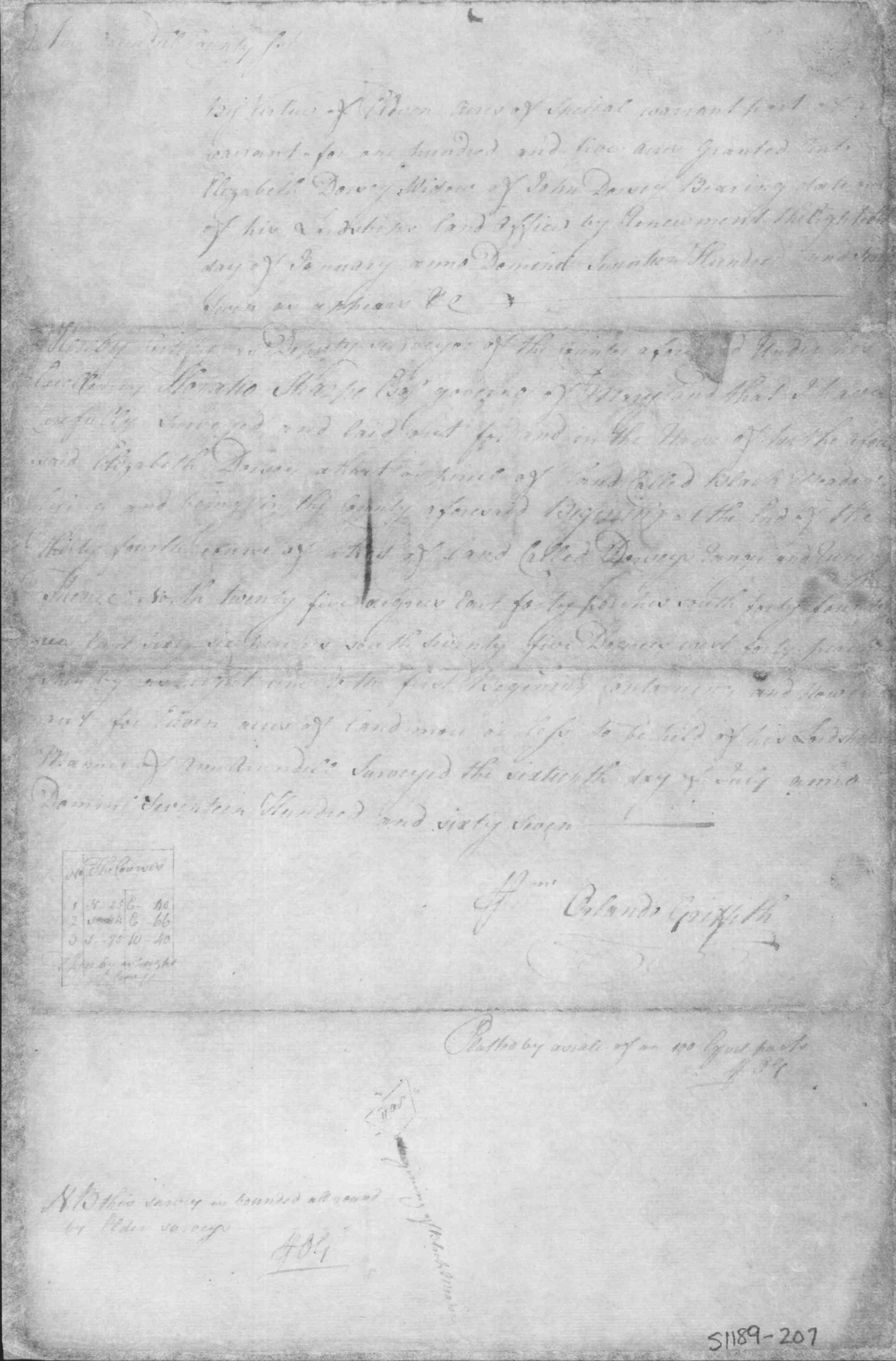
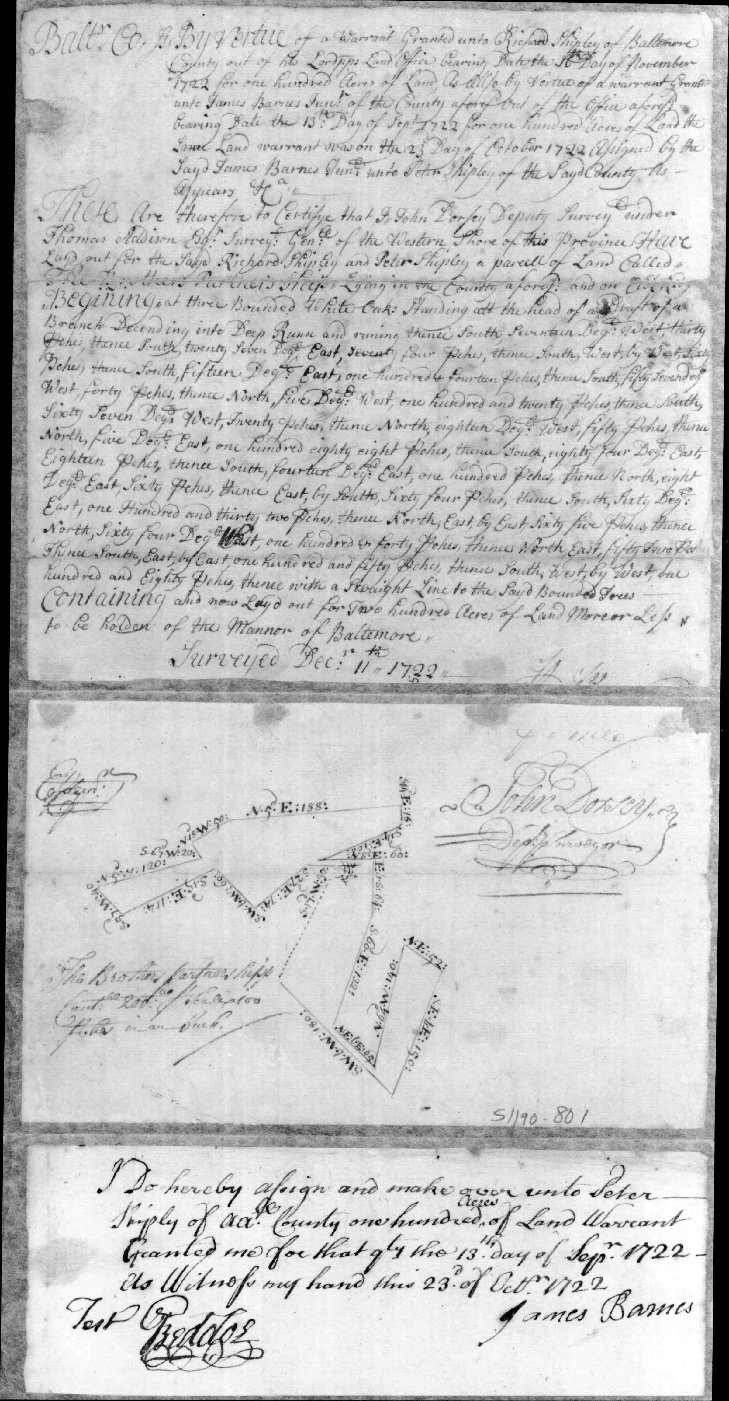
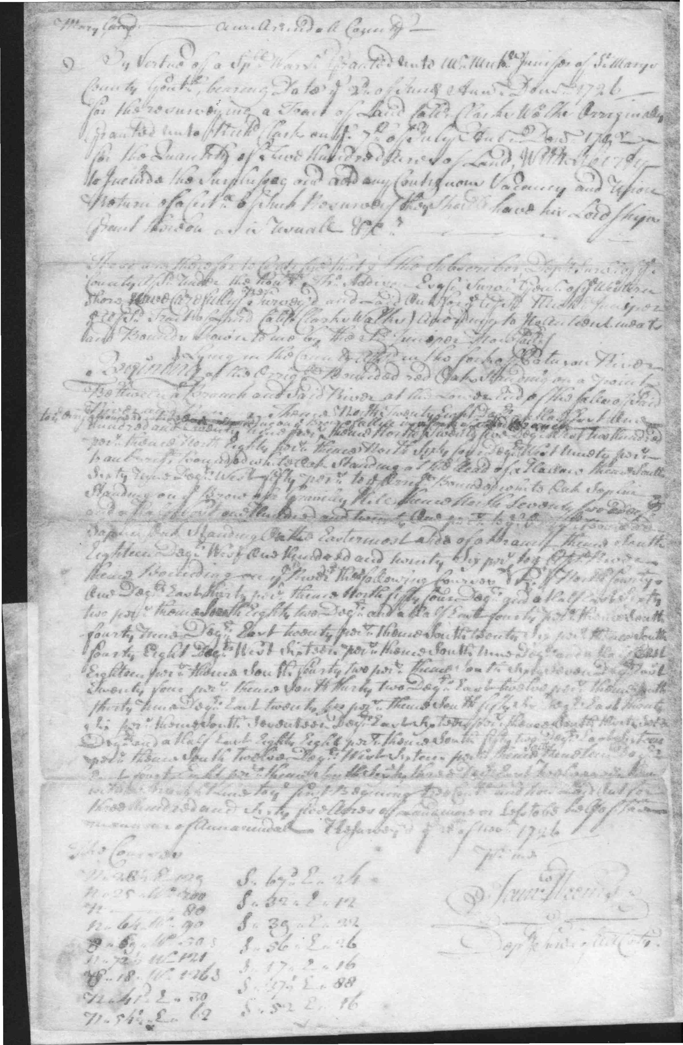
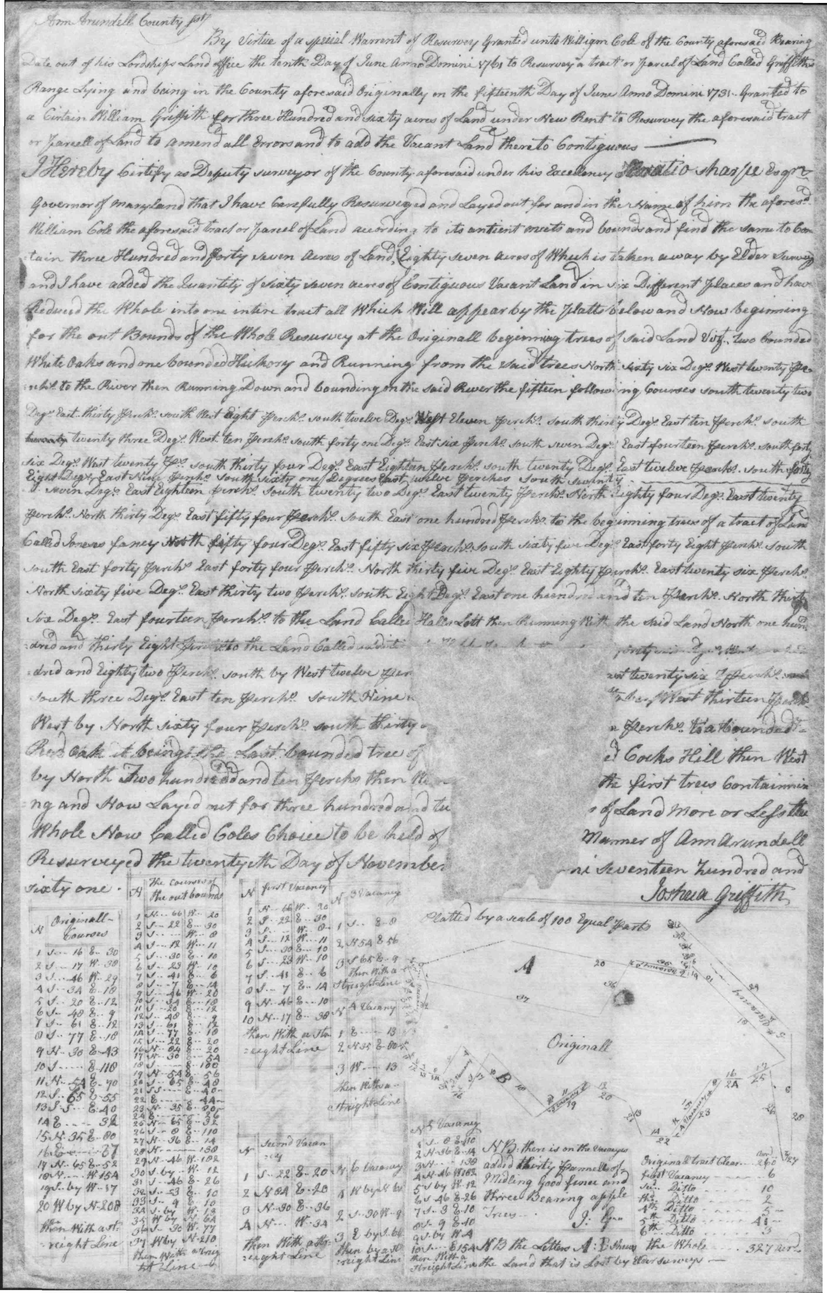
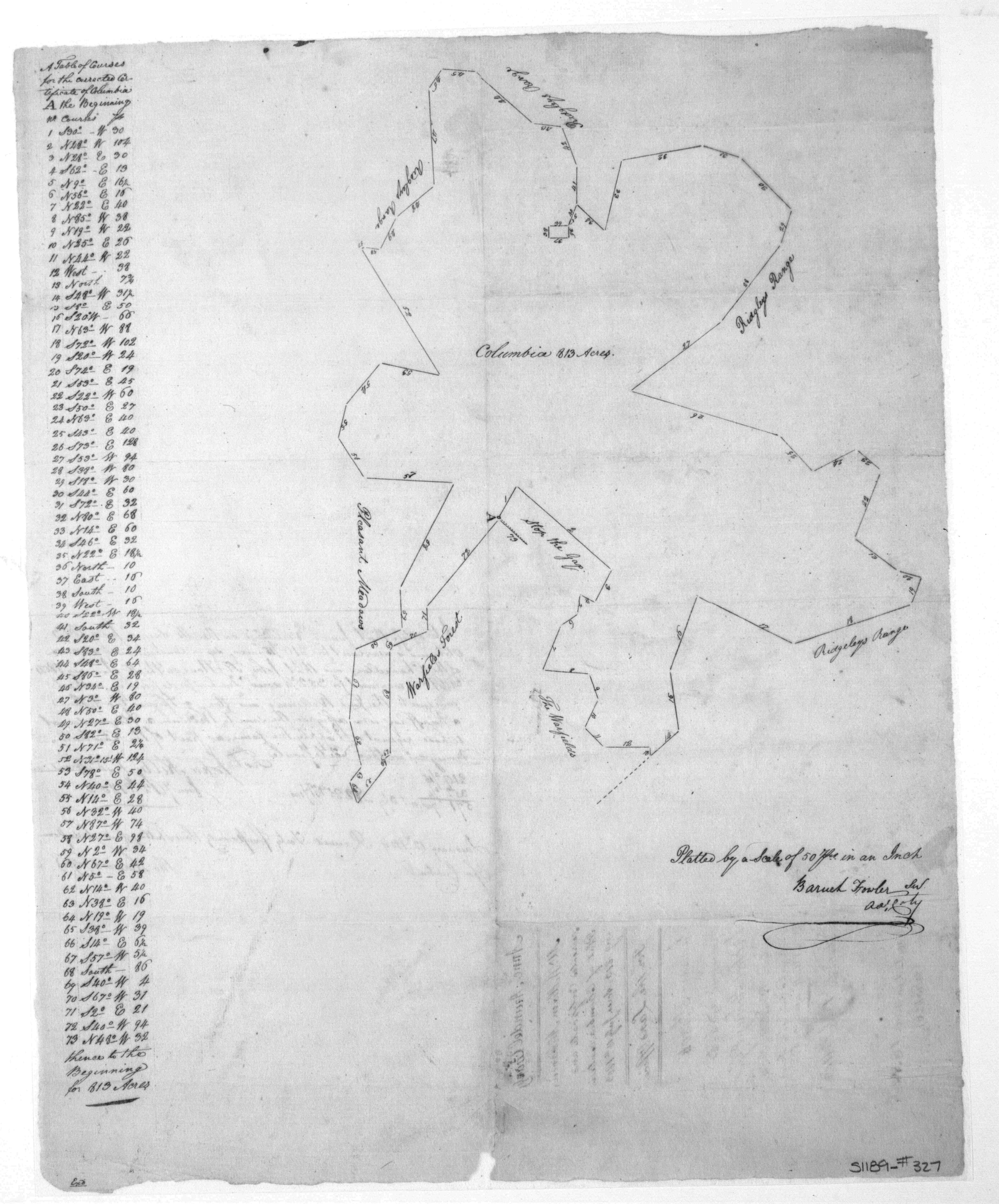
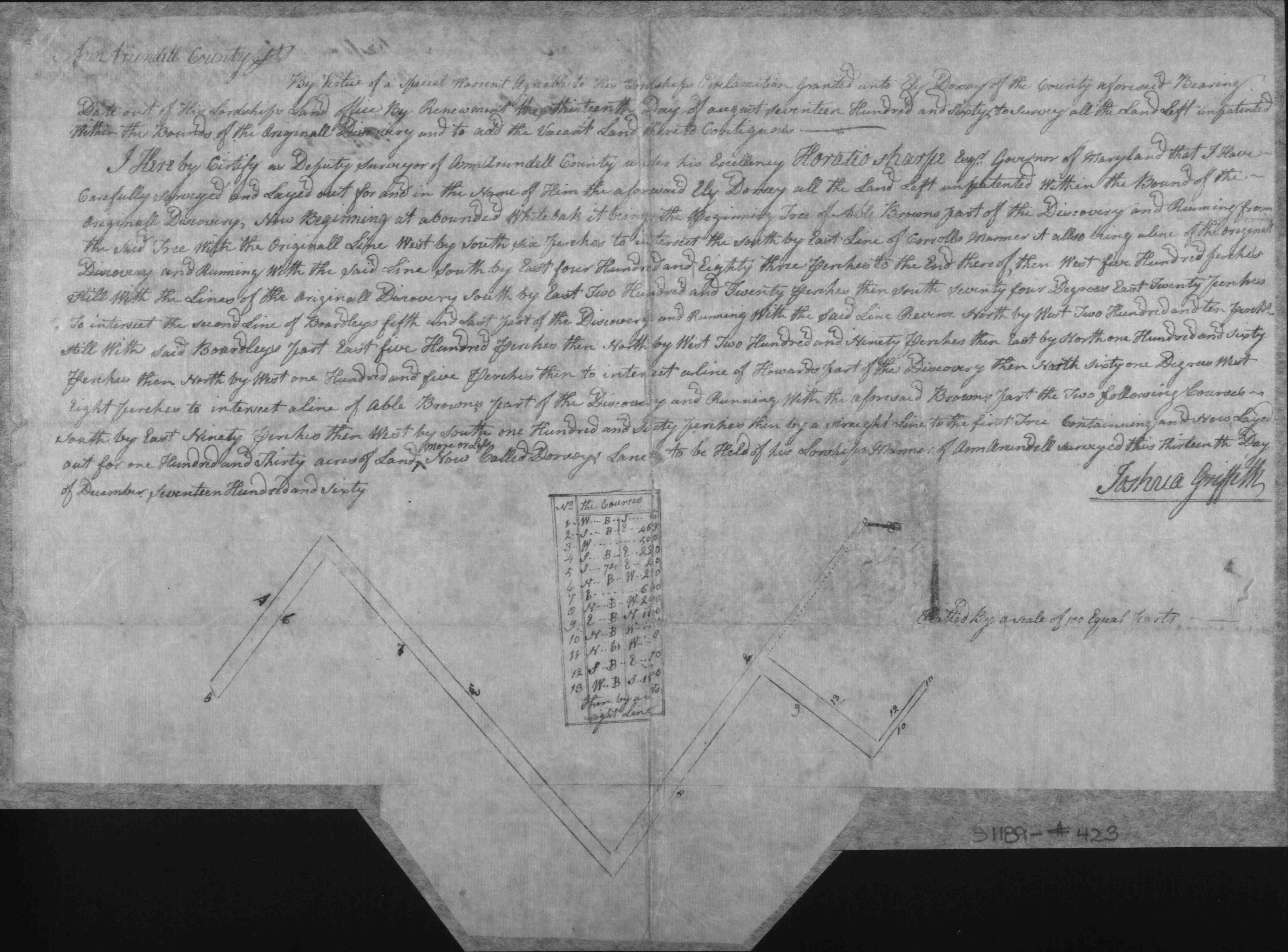
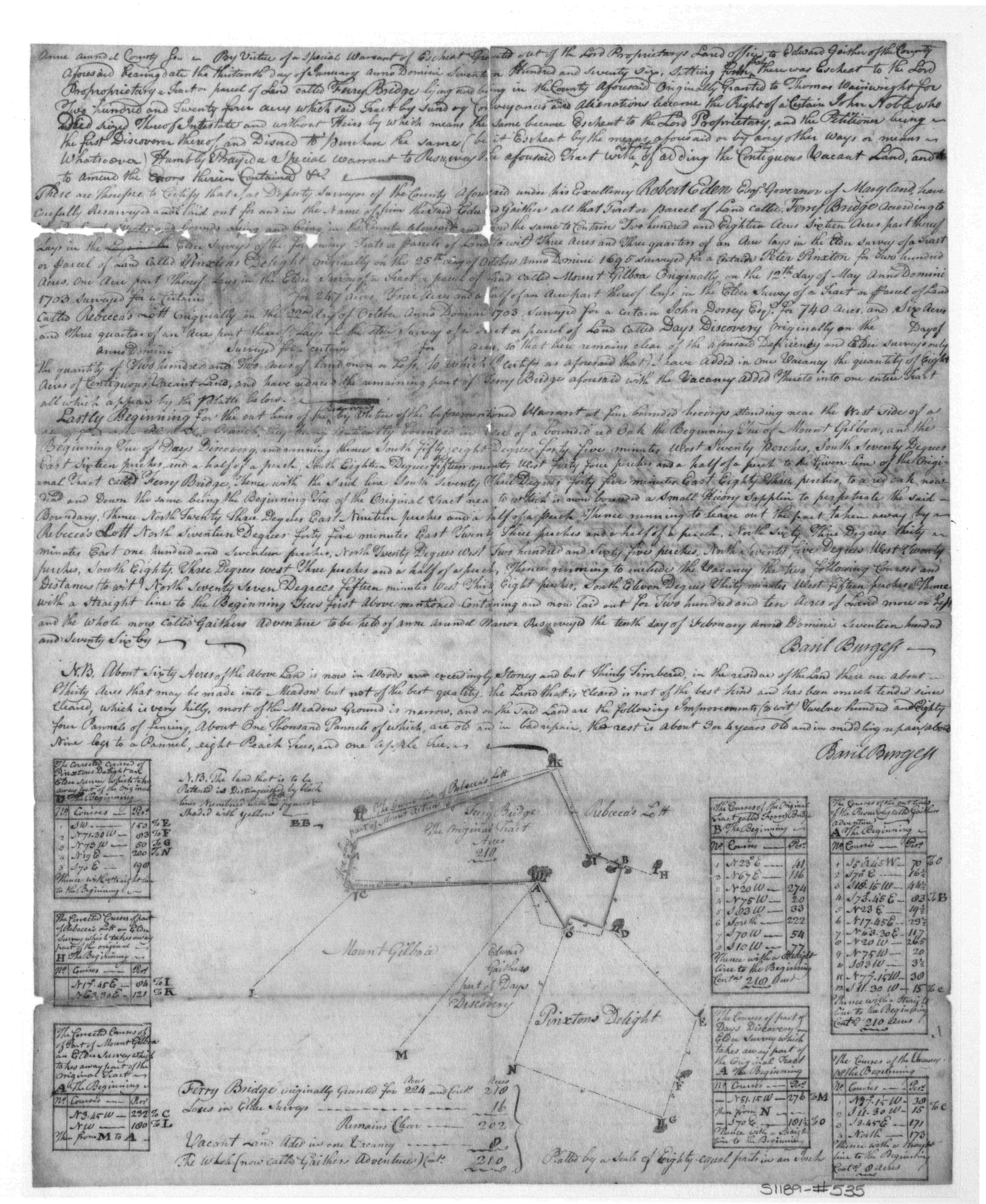
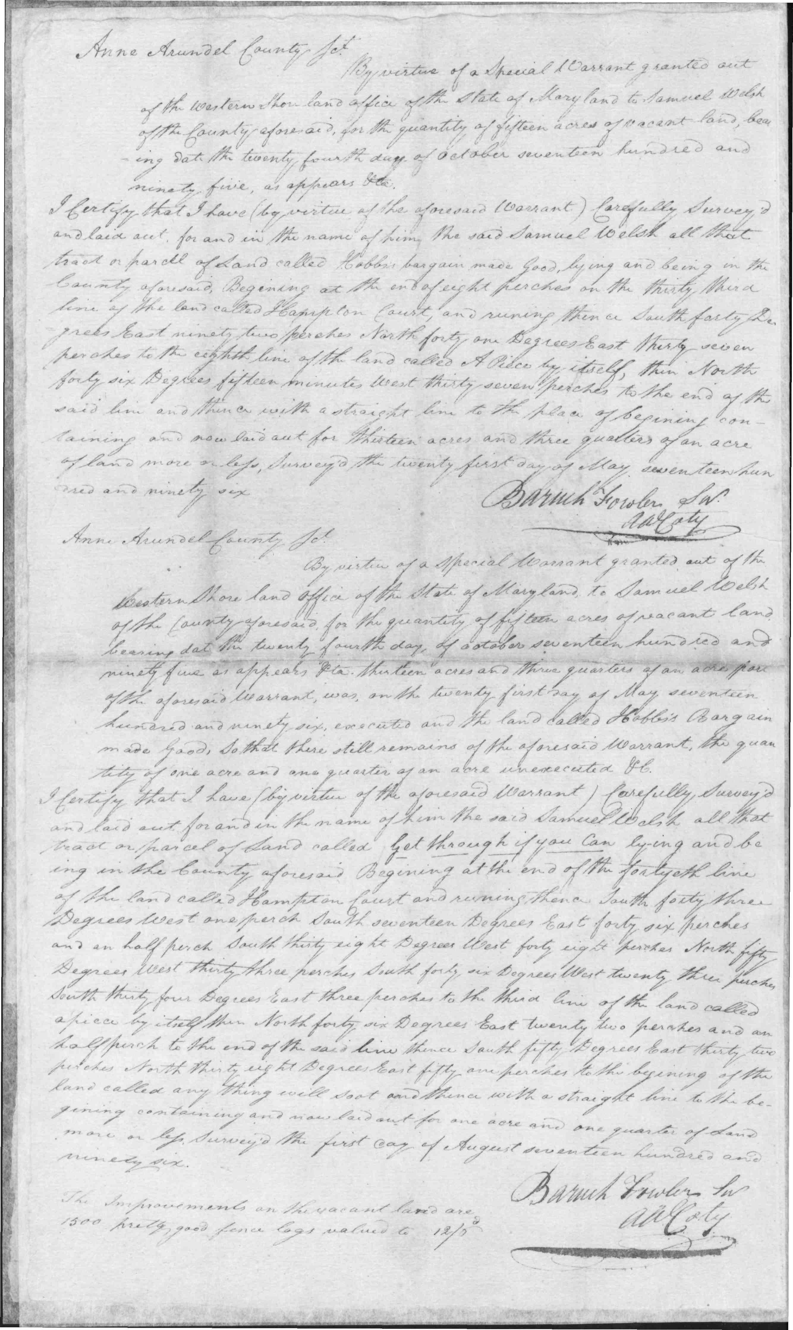
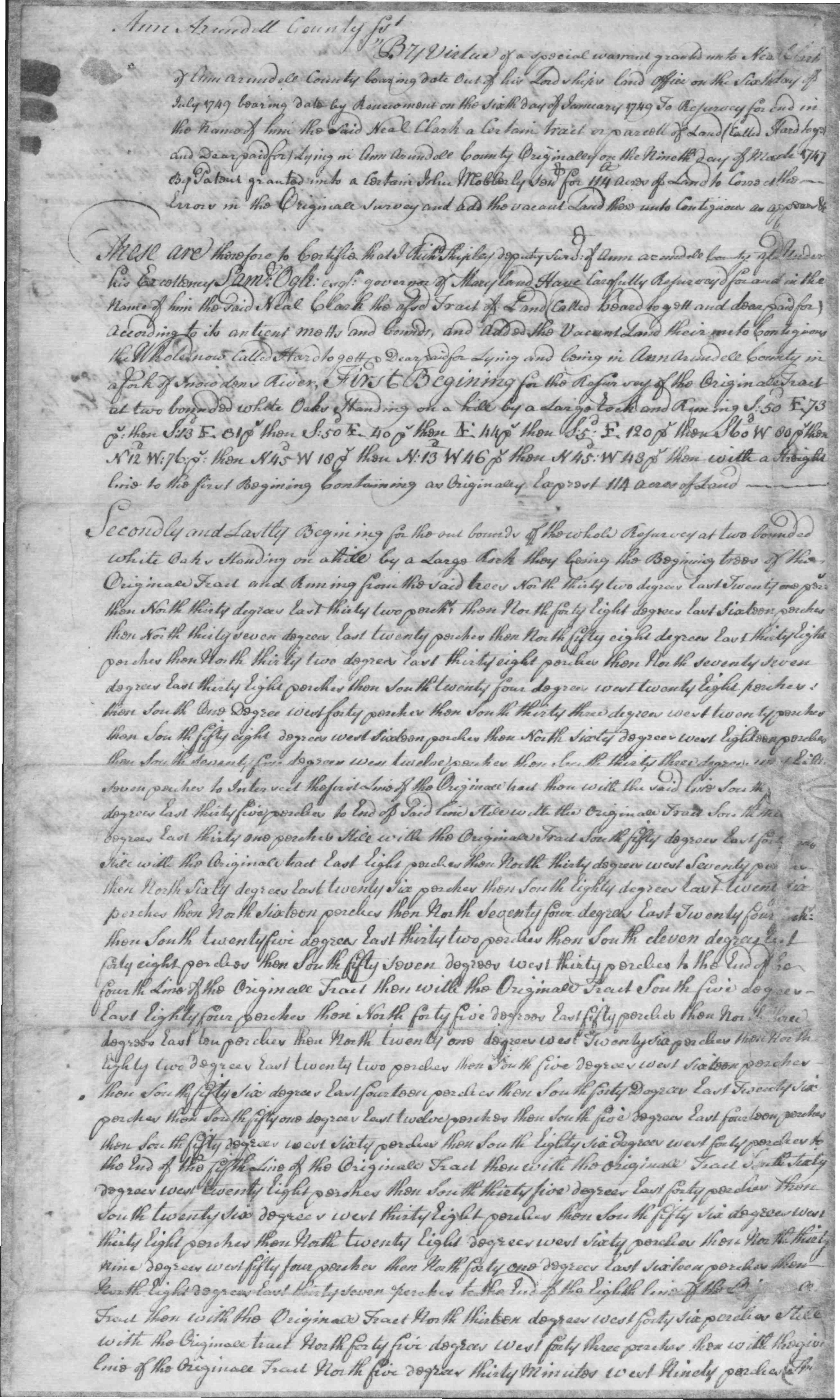
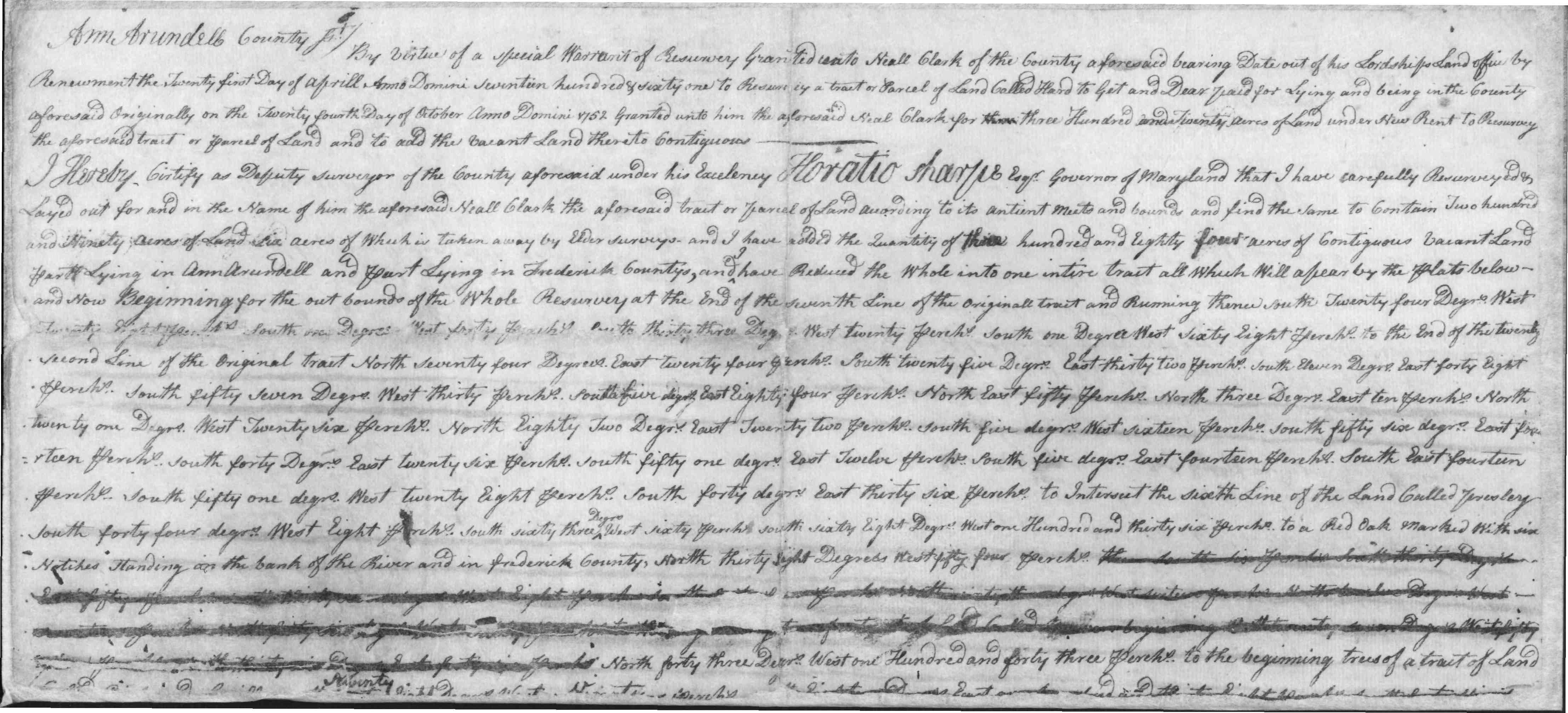
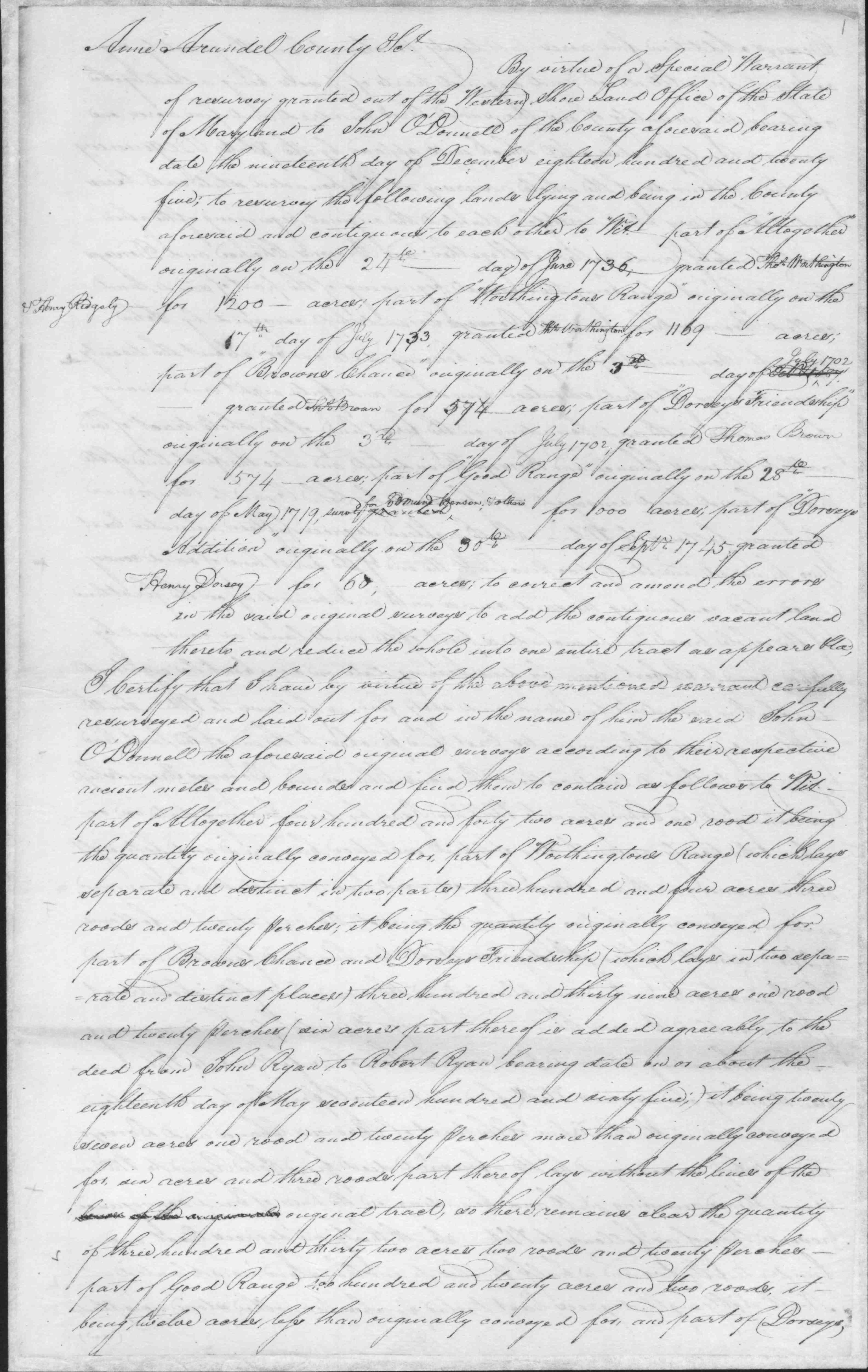
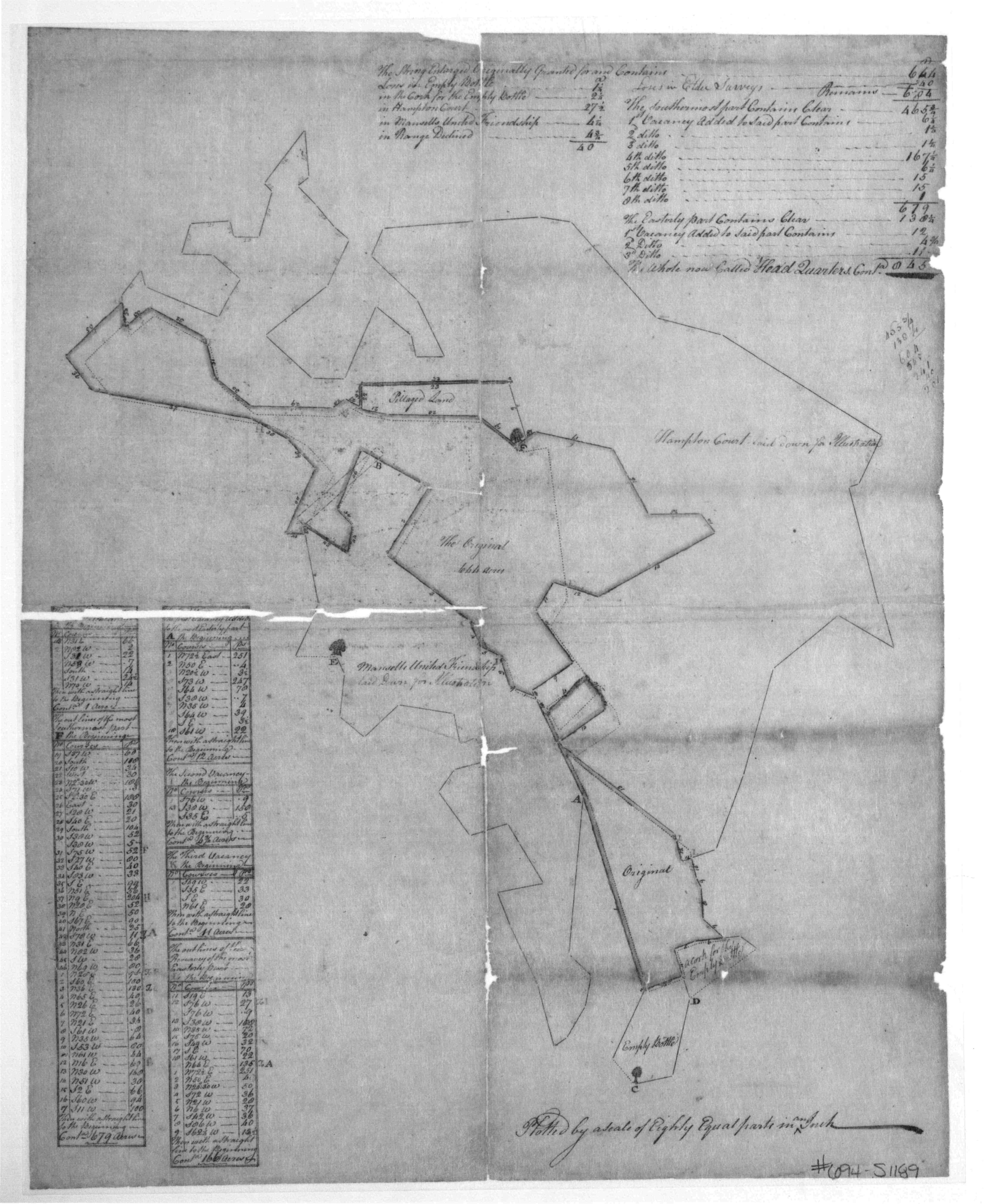
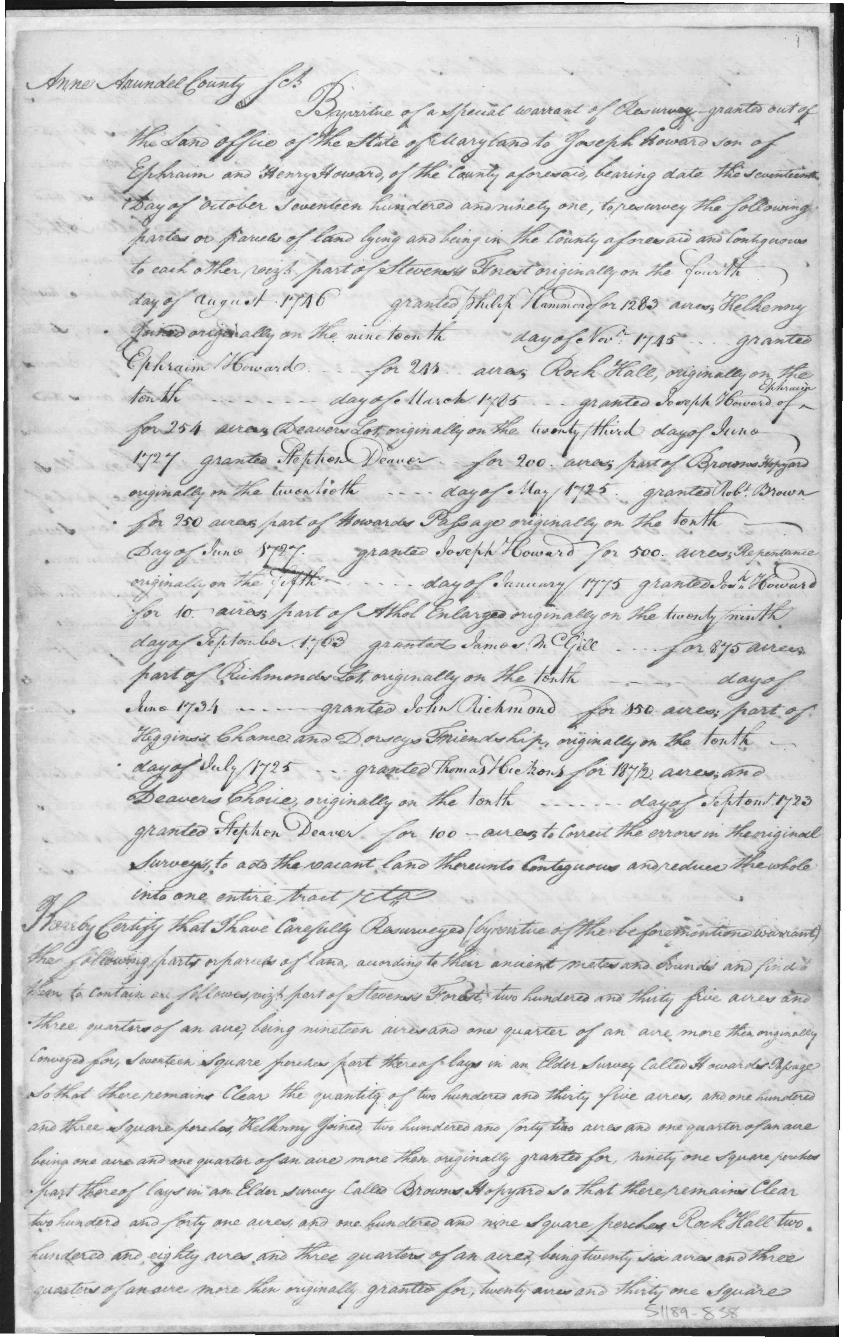
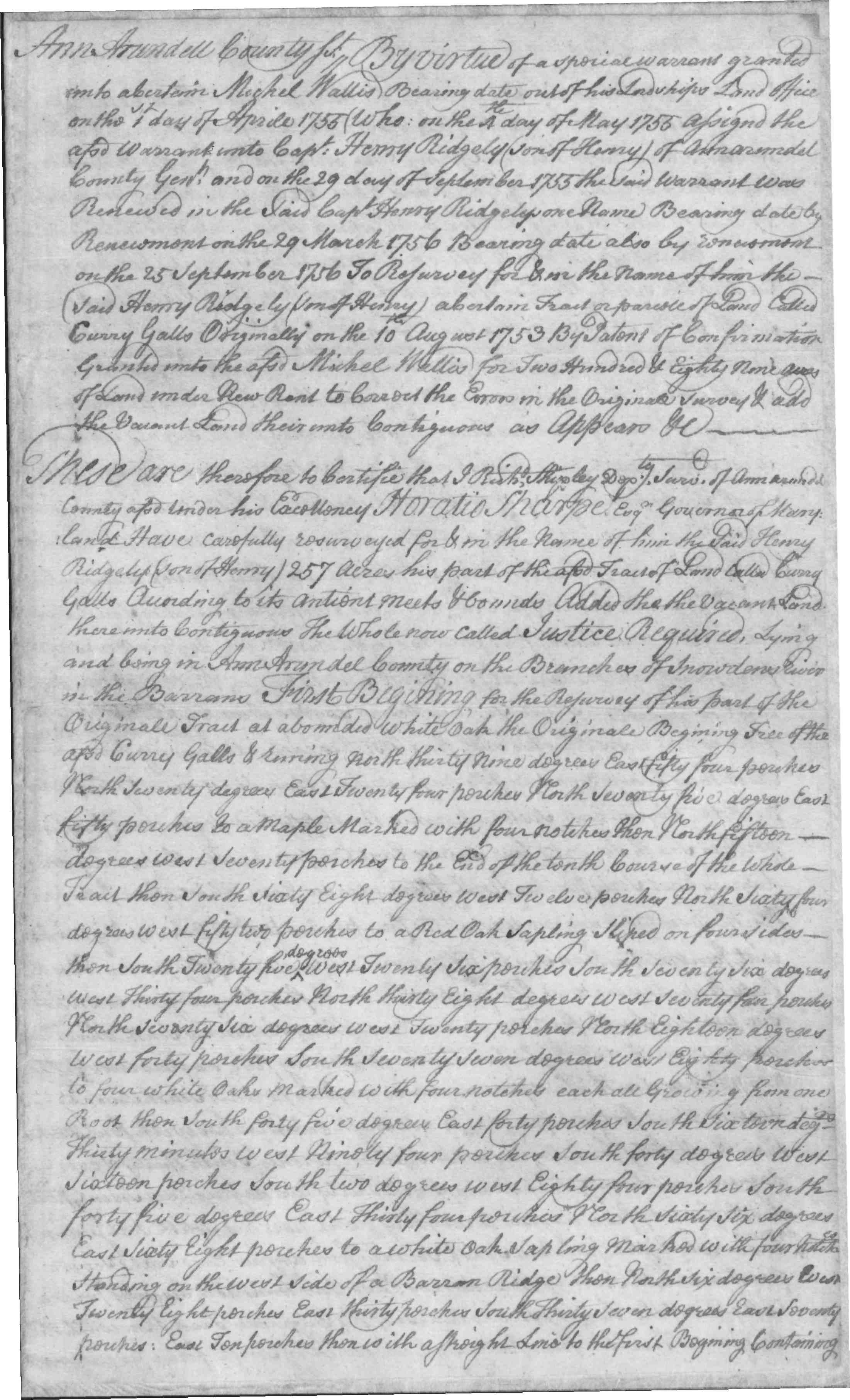
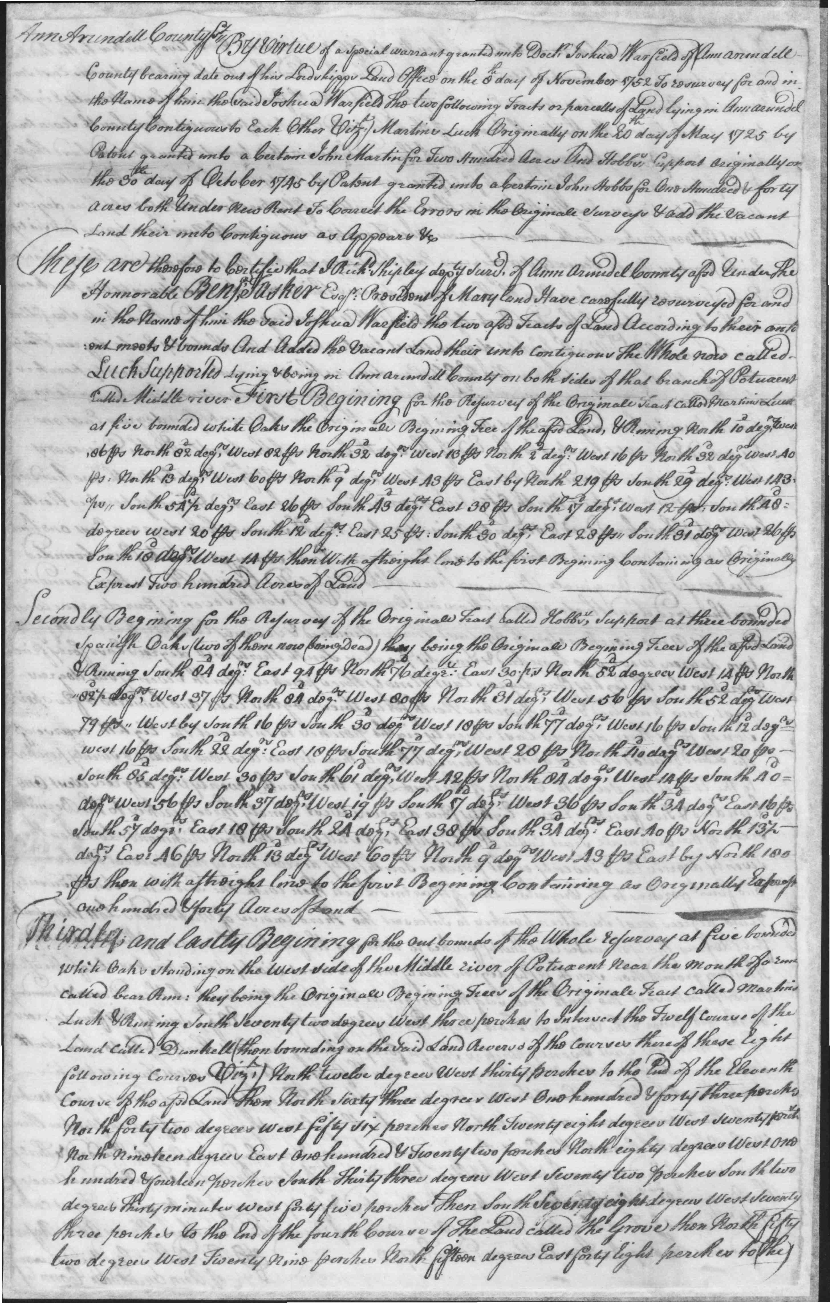
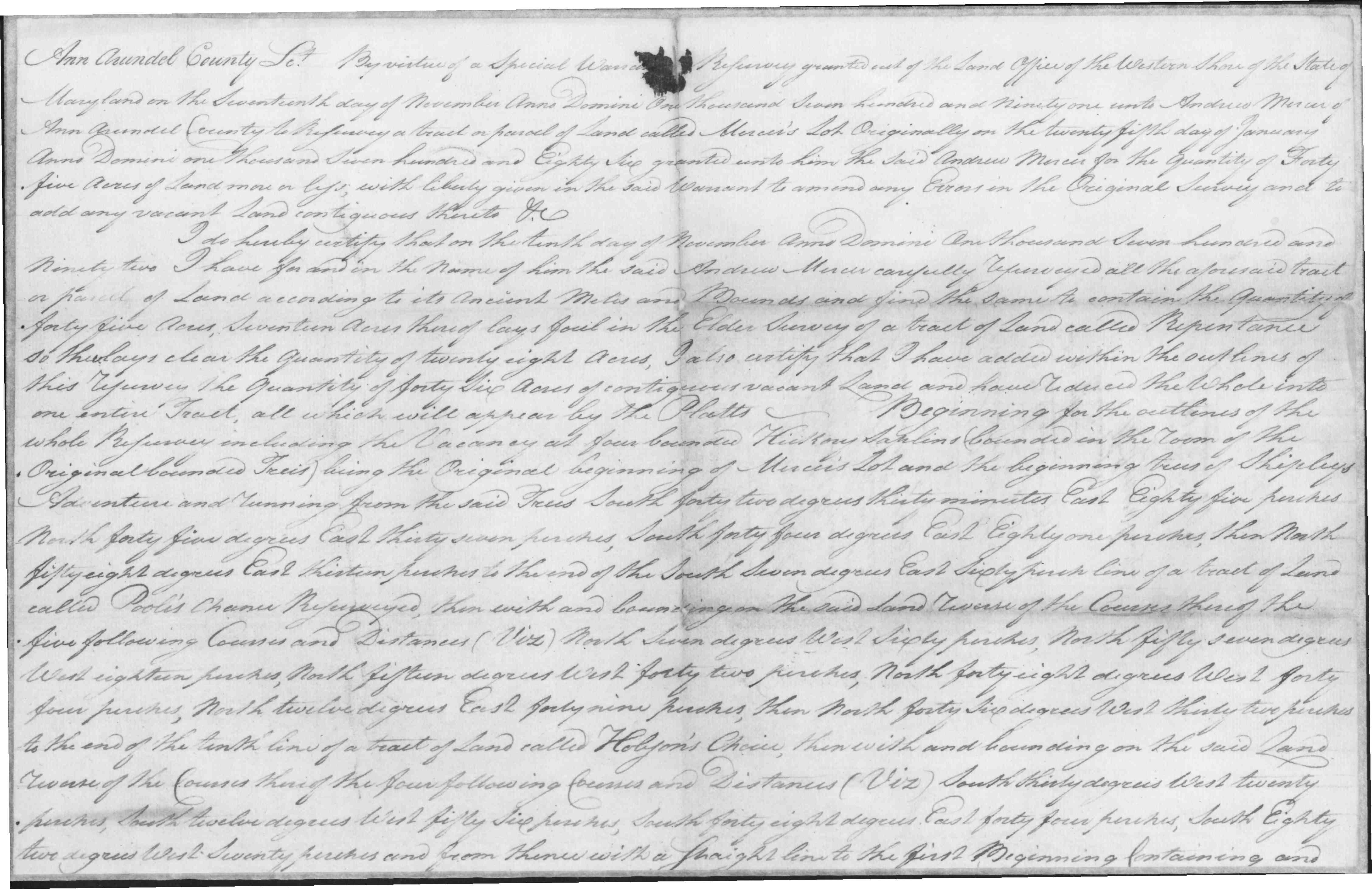
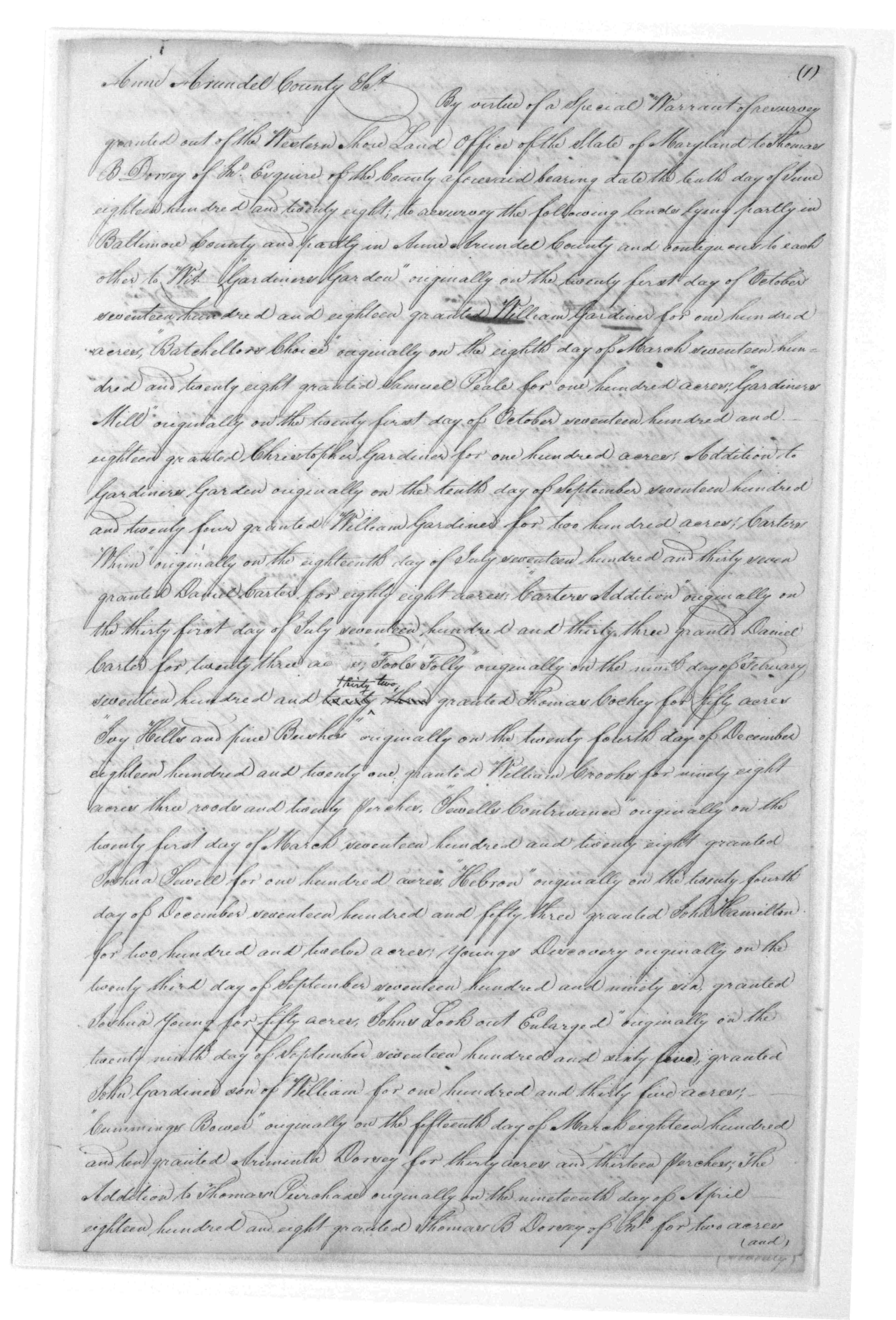
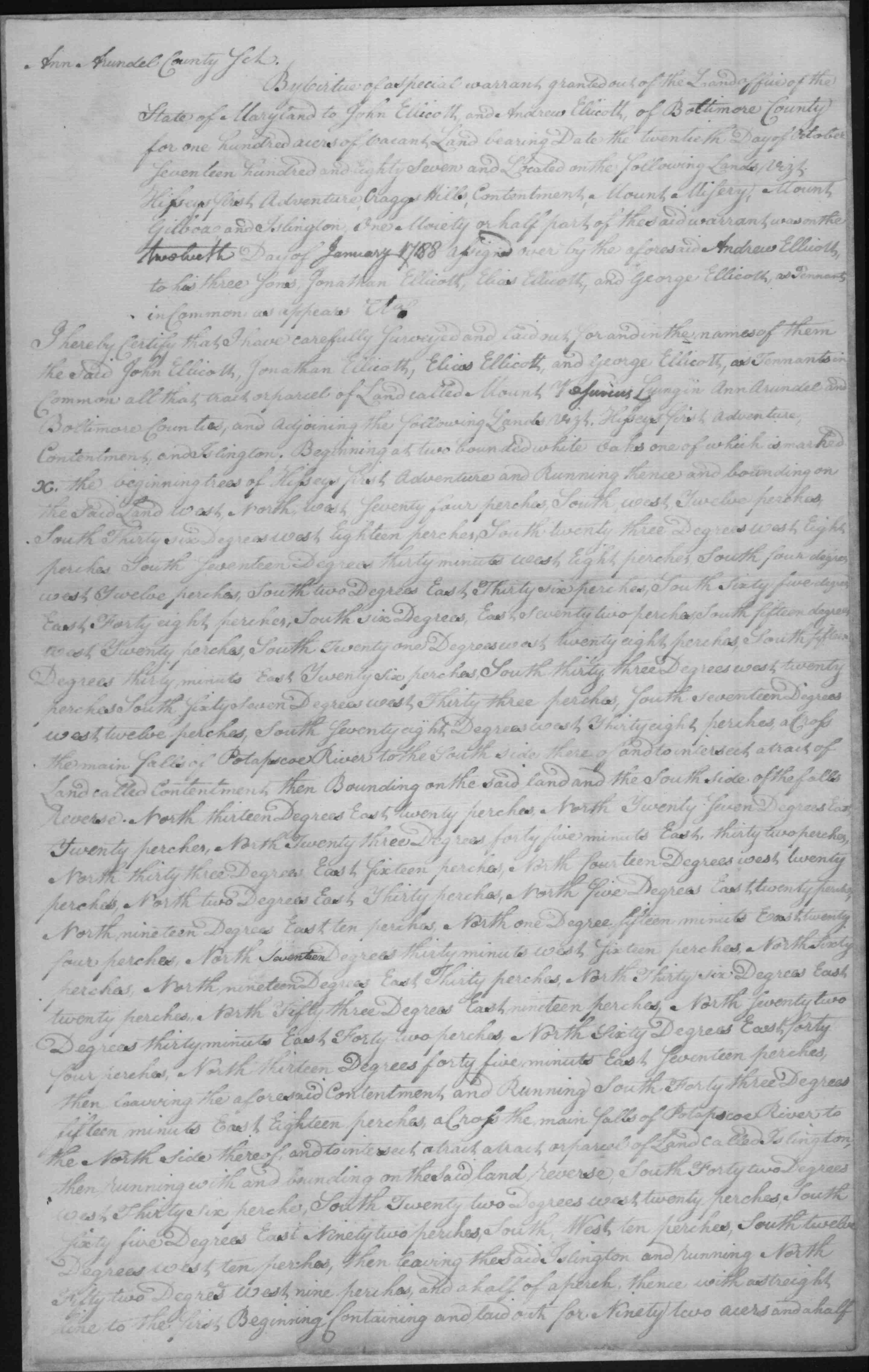
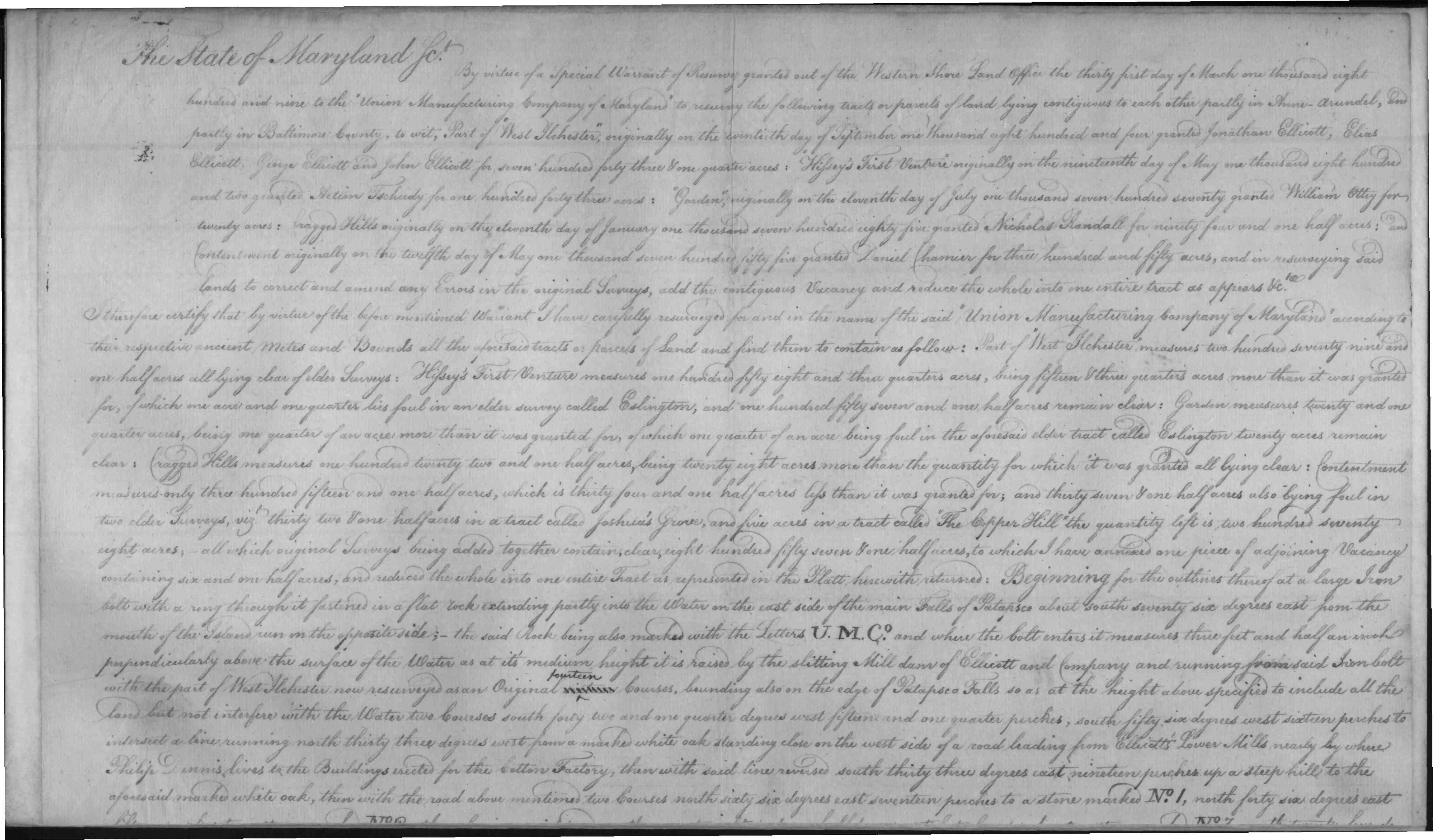
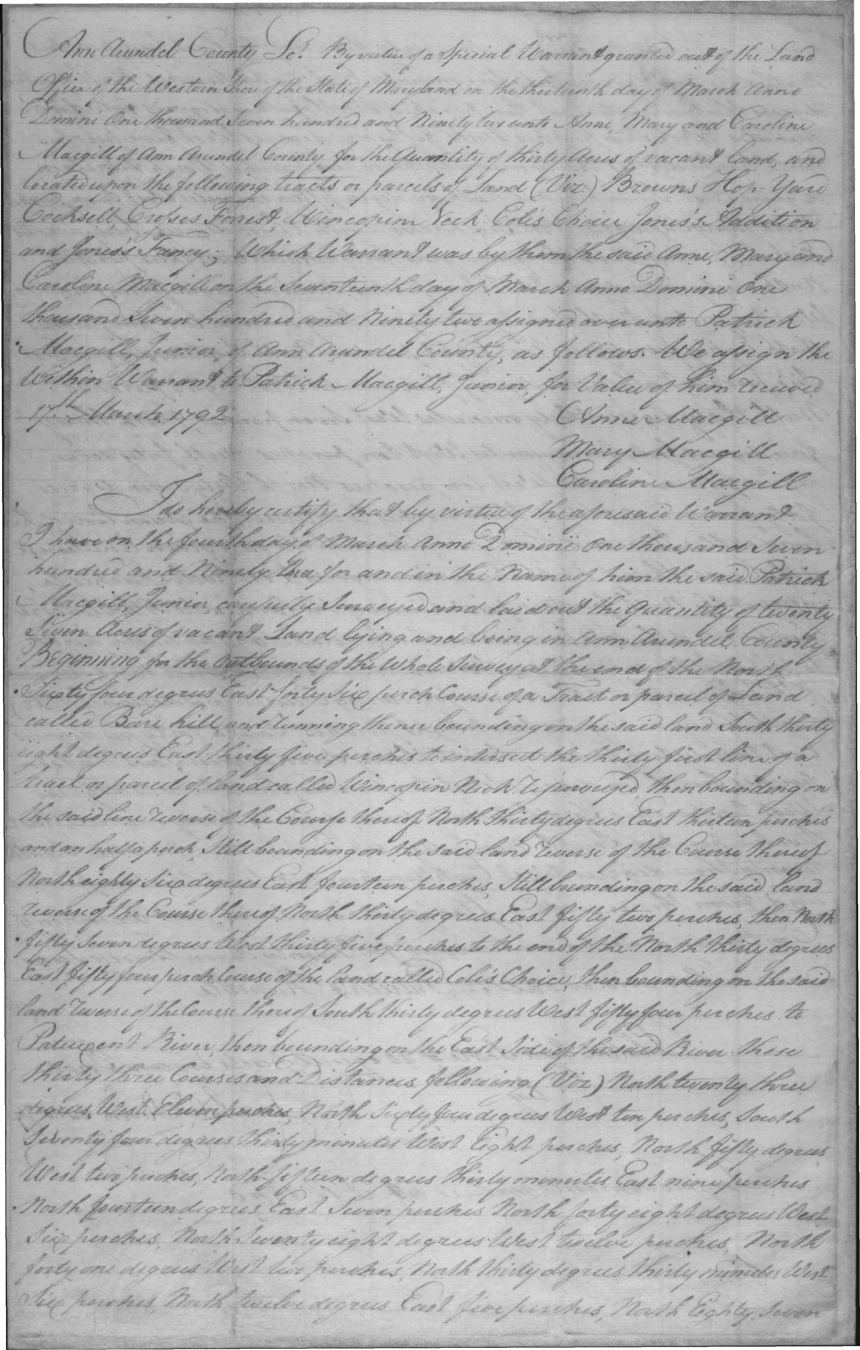
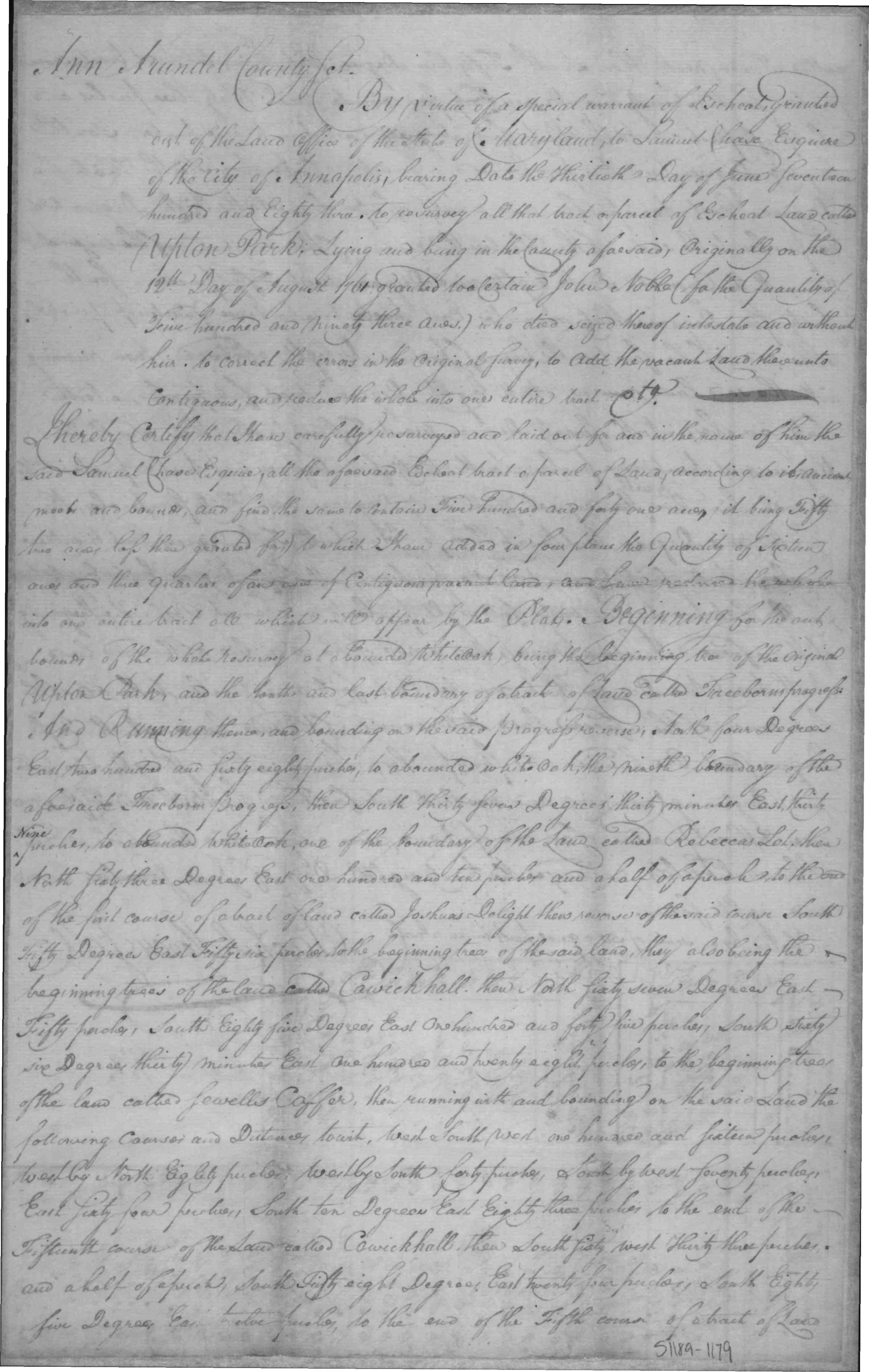
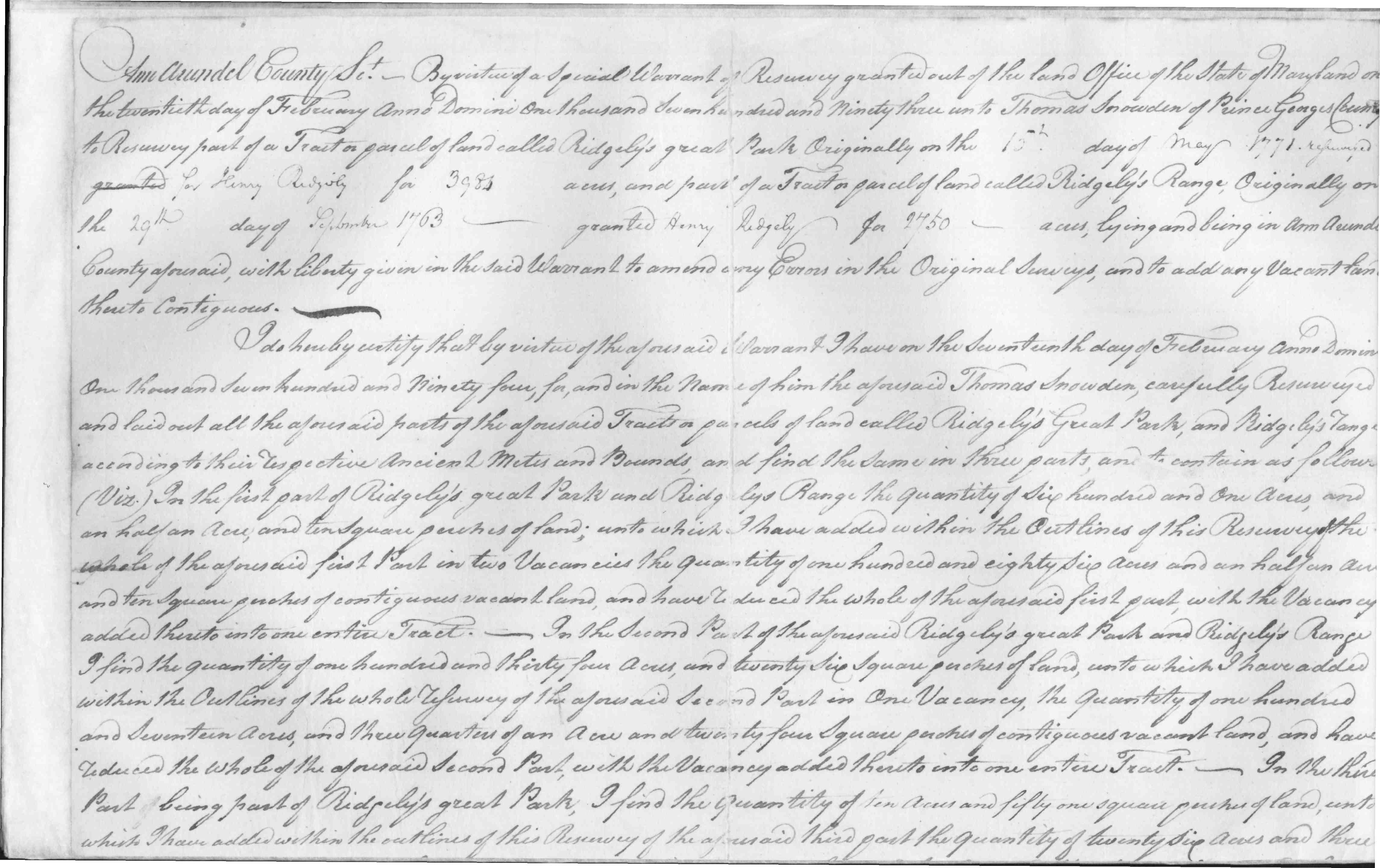
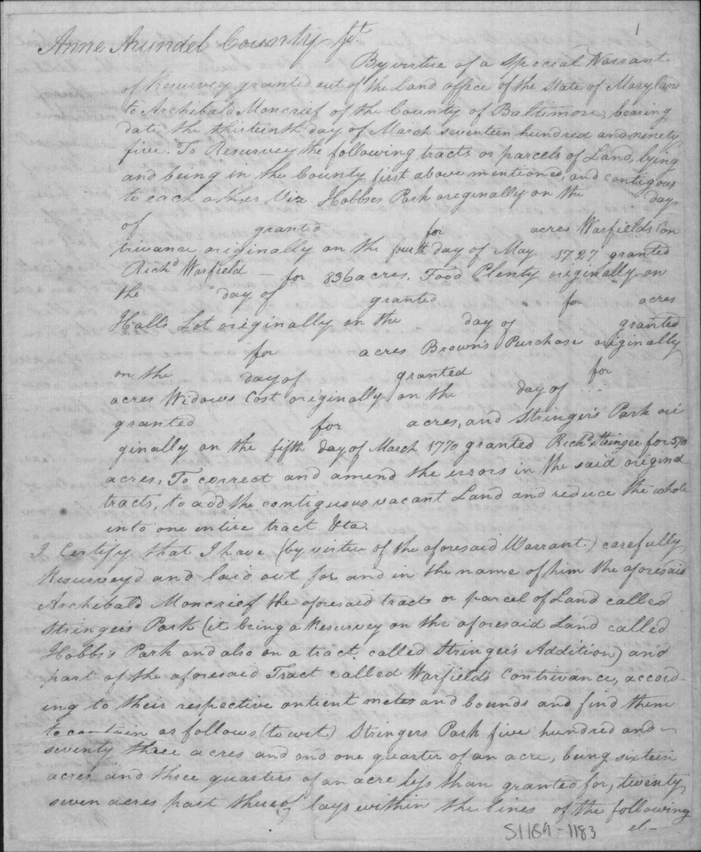
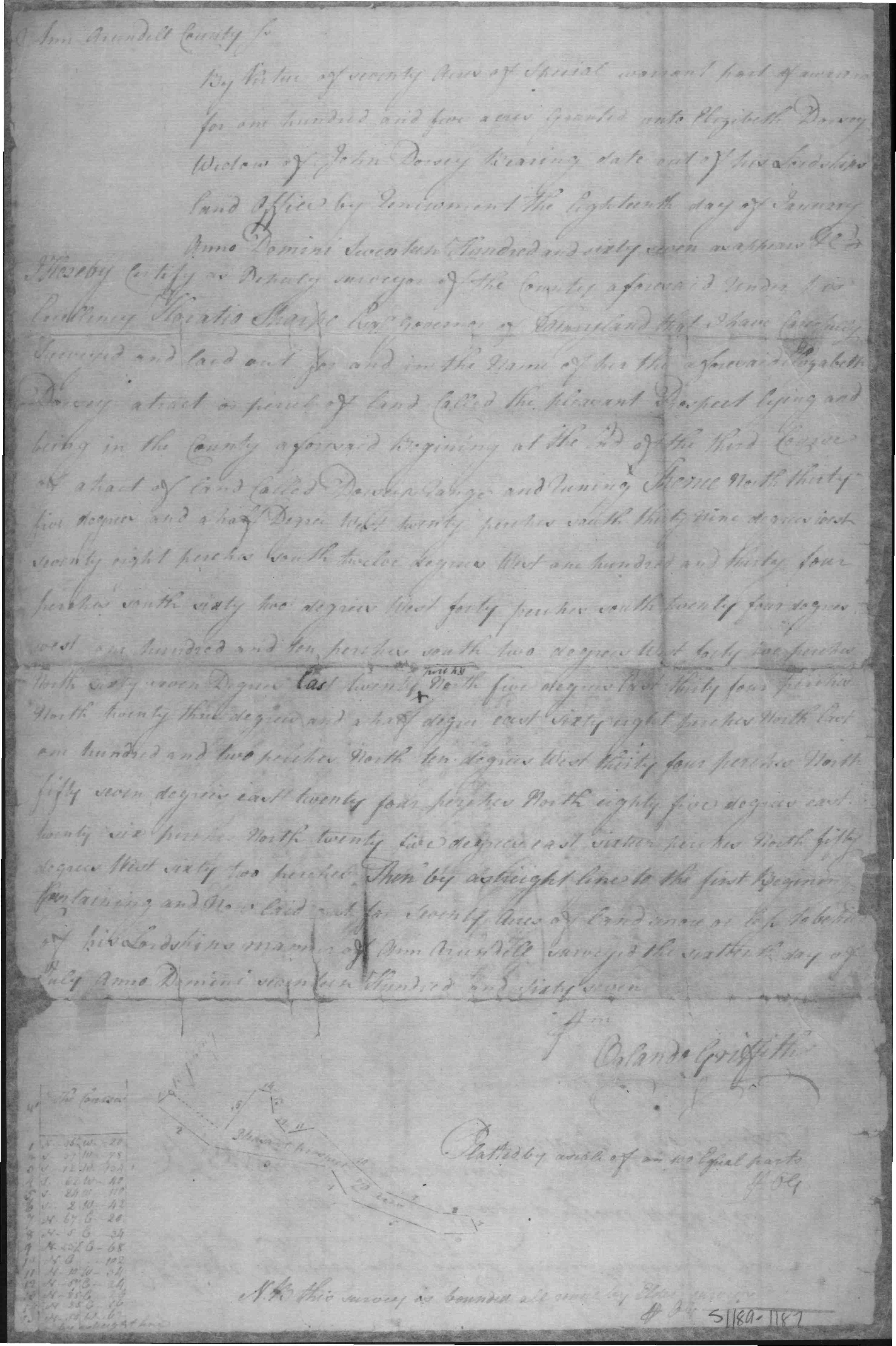
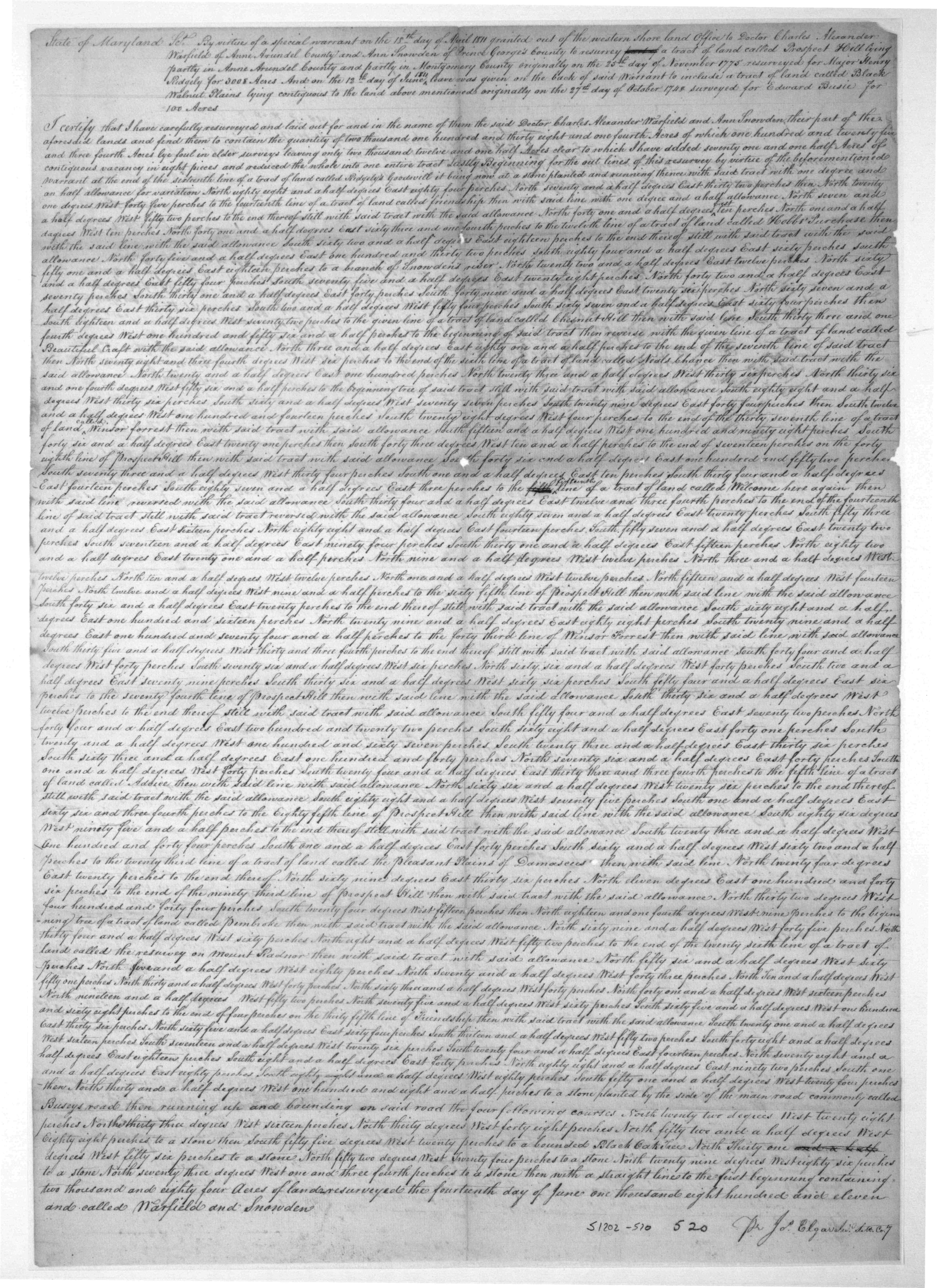
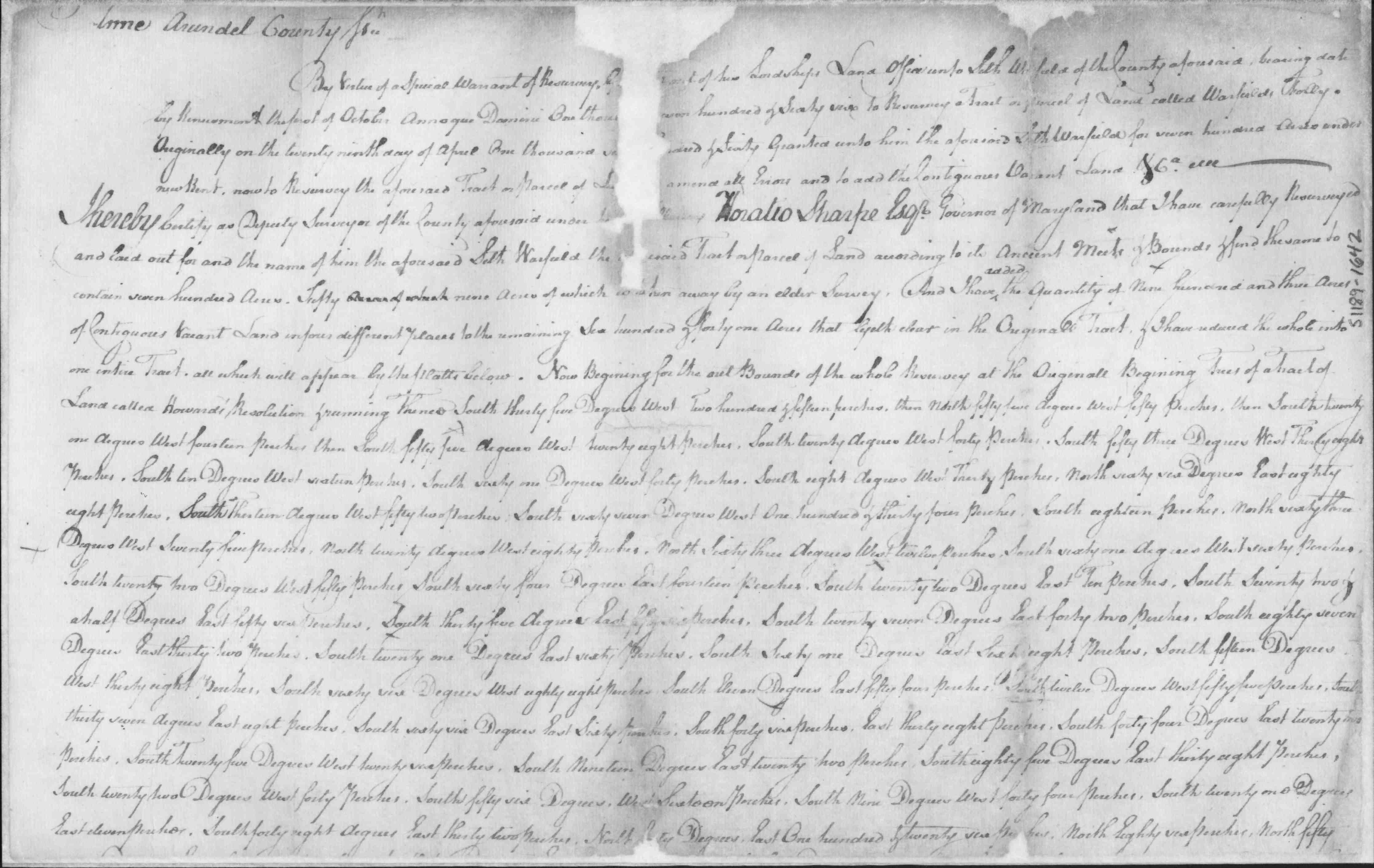
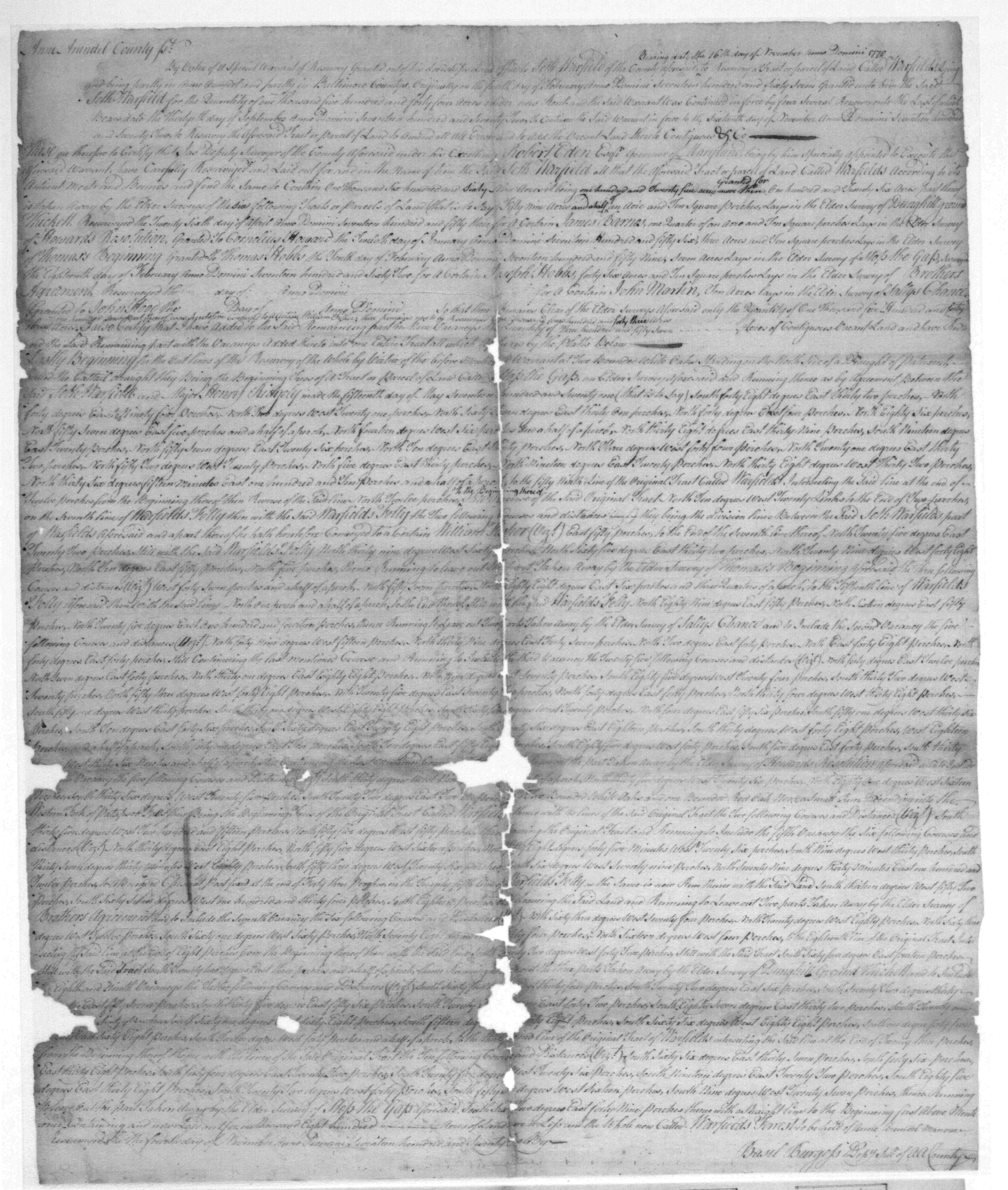
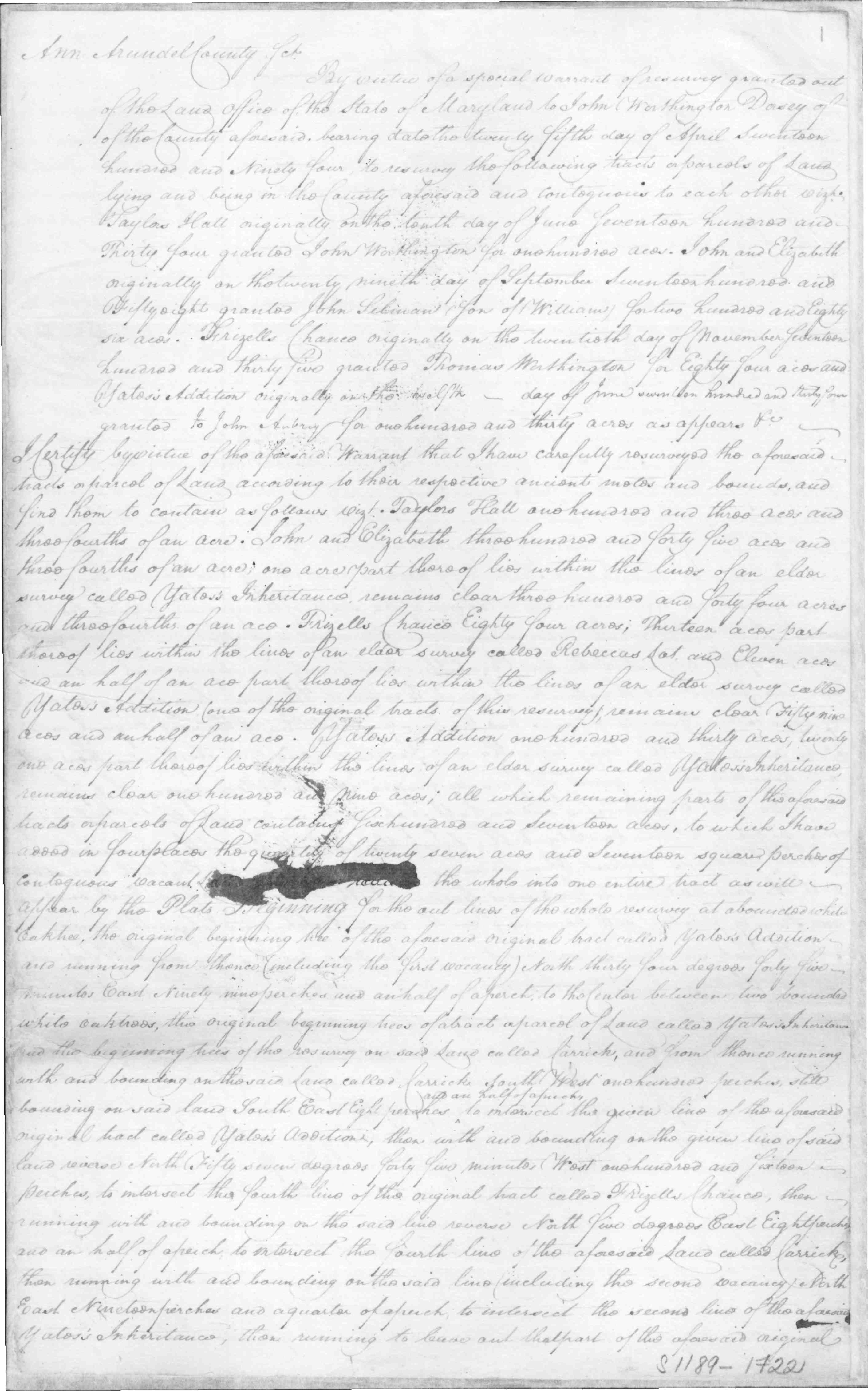